
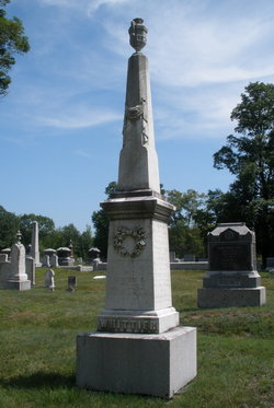
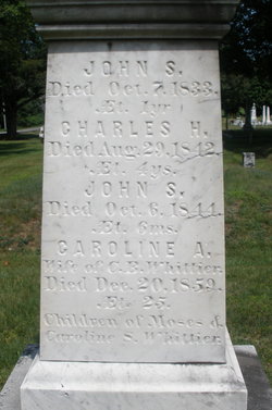
John Smith Whittier
| Birth | : | 11 Apr 1844 Readfield, Kennebec County, Maine, USA |
| Death | : | 6 Oct 1844 |
| Burial | : | St. Andrew's Churchyard, Bere Ferrers, West Devon Borough, England |
| Coordinate | : | 50.4505300, -4.1715320 |
frequently asked questions (FAQ):
-
Where is John Smith Whittier's memorial?
John Smith Whittier's memorial is located at: St. Andrew's Churchyard, Bere Ferrers, West Devon Borough, England.
-
When did John Smith Whittier death?
John Smith Whittier death on 6 Oct 1844 in
-
Where are the coordinates of the John Smith Whittier's memorial?
Latitude: 50.4505300
Longitude: -4.1715320
Family Members:
Parent

Siblings


Flowers:


Nearby Cemetories:
1. St. Andrew's Churchyard
Bere Ferrers, West Devon Borough, England
Coordinate: 50.4505300, -4.1715320
2. St Mary's Church
Tamerton Foliot, Plymouth Unitary Authority, England
Coordinate: 50.4279200, -4.1582500
3. Holy Trinity Churchyard
Bere Alston, West Devon Borough, England
Coordinate: 50.4789735, -4.1881879
4. St. Leonard & St. Dilpe Churchyard
Landulph, Cornwall Unitary Authority, England
Coordinate: 50.4324670, -4.2104830
5. St Budoc Churchyard
St Budeaux, Plymouth Unitary Authority, England
Coordinate: 50.4130353, -4.1769516
6. St. Pancras Churchyard
Pennycross, Plymouth Unitary Authority, England
Coordinate: 50.4012300, -4.1510700
7. Saint Andrew's Churchyard
Buckland Monachorum, West Devon Borough, England
Coordinate: 50.4951167, -4.1302055
8. St. Pancras Church Cemetery
Pennycross, Plymouth Unitary Authority, England
Coordinate: 50.4004000, -4.1497900
9. Buckland Monachorum Village Cemetery
Buckland Monachorum, West Devon Borough, England
Coordinate: 50.4962980, -4.1305260
10. St Mary's Botus Fleming
Botus Fleming, Cornwall Unitary Authority, England
Coordinate: 50.4298100, -4.2483700
11. Weston Mill Cemetery and Crematorium
Plymouth, Plymouth Unitary Authority, England
Coordinate: 50.3954330, -4.1719780
12. St. Mary's Churchyard
Bickleigh, South Hams District, England
Coordinate: 50.4420600, -4.0844100
13. St Andrew Churchyard
Calstock, Cornwall Unitary Authority, England
Coordinate: 50.5021270, -4.2062400
14. Calstock Cemetery
Calstock, Cornwall Unitary Authority, England
Coordinate: 50.5021300, -4.2082100
15. Estover
Estover, Plymouth Unitary Authority, England
Coordinate: 50.4100000, -4.1000000
16. St. Edward's Churchyard
Eggbuckland, Plymouth Unitary Authority, England
Coordinate: 50.4007100, -4.1146830
17. Gifford Place Jewish Cemetery
Plymouth, Plymouth Unitary Authority, England
Coordinate: 50.3841970, -4.1408370
18. Milehouse Cemetery
Devonport, Plymouth Unitary Authority, England
Coordinate: 50.3814650, -4.1636975
19. Albaston Cemetery
Calstock, Cornwall Unitary Authority, England
Coordinate: 50.5133240, -4.2225080
20. Ford Park Cemetery
Plymouth, Plymouth Unitary Authority, England
Coordinate: 50.3813700, -4.1446090
21. Efford Cemetery and Crematorium
Plymouth, Plymouth Unitary Authority, England
Coordinate: 50.3908900, -4.1100080
22. St. John the Baptist
Horrabridge, West Devon Borough, England
Coordinate: 50.5079900, -4.0992400
23. St. Andrew with St. Luke Churchyard
Devonport, Plymouth Unitary Authority, England
Coordinate: 50.3747560, -4.1625170
24. St Peter and The Holy Apostles Churchyard
Plymouth, Plymouth Unitary Authority, England
Coordinate: 50.3731580, -4.1544280