
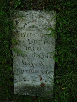
| Birth | : | 21 Feb 1832 Tippecanoe County, Indiana, USA |
| Death | : | 11 Feb 1897 Nemaha County, Nebraska, USA |
| Burial | : | Nemaha Cemetery, Nemaha, Nemaha County, USA |
| Coordinate | : | 40.3469009, -95.6596985 |
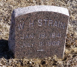
| Inscription | : | John Strain Feb 21, 1832 Feb 11, 1897 |
| Description | : | Thank you contributor Laura L. JOHN STRAIN, farmer, P. O. Nemaha City, was born in 1832, in Tippecanoe County, Ind.; removed in 1854, to Iowa, thence to Missouri, and thence to Kansas. In this then new Territory, during the years 1855-56, he saw much of " border ruffianism" in its worst phases. Himself a strong Abolitionist, he was warned repeatedly to leave the Territory, on pain of death, but instead, organized and became Captain of a company of thirty determined Northern men, who were bound to defend themselves and each other against all comers. By skillful night marches Capt. Strain got... Read More |
frequently asked questions (FAQ):
-
Where is John Strain's memorial?
John Strain's memorial is located at: Nemaha Cemetery, Nemaha, Nemaha County, USA.
-
When did John Strain death?
John Strain death on 11 Feb 1897 in Nemaha County, Nebraska, USA
-
Where are the coordinates of the John Strain's memorial?
Latitude: 40.3469009
Longitude: -95.6596985
Family Members:
Parent

Spouse
Siblings
Children
Flowers:


Nearby Cemetories:
1. Nemaha Cemetery
Nemaha, Nemaha County, USA
Coordinate: 40.3469009, -95.6596985
2. Walnut Grove Cemetery
Brownville, Nemaha County, USA
Coordinate: 40.4023056, -95.6642990
3. Hillsdale Cemetery
Nemaha County, USA
Coordinate: 40.2882996, -95.6010971
4. Penniwell Cemetery
Shubert, Richardson County, USA
Coordinate: 40.2619000, -95.6994500
5. Kite Cemetery
Nemaha County, USA
Coordinate: 40.3414001, -95.7842026
6. Honey Creek Cemetery
Nemaha Township, Nemaha County, USA
Coordinate: 40.4430199, -95.6980820
7. Millsap Cemetery
Rock Port, Atchison County, USA
Coordinate: 40.4150009, -95.5532990
8. Hunter Cemetery
Rock Port, Atchison County, USA
Coordinate: 40.3636017, -95.5216980
9. Lansdown family burial site
Rock Port, Atchison County, USA
Coordinate: 40.4154319, -95.5522575
10. Prairie Union Cemetery
Shubert, Richardson County, USA
Coordinate: 40.2475800, -95.7150200
11. London Cemetery
Peru, Nemaha County, USA
Coordinate: 40.4225006, -95.7621994
12. Half-Breed Cemetery
Nemaha County, USA
Coordinate: 40.2664900, -95.5604900
13. Saint Deroin Cemetery
Barada, Richardson County, USA
Coordinate: 40.2543983, -95.5682983
14. Brick Church Cemetery
Barada, Richardson County, USA
Coordinate: 40.2328000, -95.6155000
15. Elmwood Cemetery
Rock Port, Atchison County, USA
Coordinate: 40.4062740, -95.5206080
16. Berg Cemetery
Barada, Richardson County, USA
Coordinate: 40.2257996, -95.6168976
17. Sonora Cemetery
Watson, Atchison County, USA
Coordinate: 40.4730988, -95.6521988
18. County Home Cemetery
Rock Port, Atchison County, USA
Coordinate: 40.4180310, -95.5163740
19. Bush Cemetery
Atchison County, USA
Coordinate: 40.3558006, -95.4858017
20. Greenhill Cemetery
Rock Port, Atchison County, USA
Coordinate: 40.4143982, -95.5074997
21. Bedford Cemetery
Howe, Nemaha County, USA
Coordinate: 40.3128014, -95.8308029
22. Holy Cross Cemetery
Nemaha County, USA
Coordinate: 40.3417015, -95.8405991
23. Mount Vernon Cemetery
Peru, Nemaha County, USA
Coordinate: 40.4768982, -95.7208023
24. Addington Cemetery
Watson, Atchison County, USA
Coordinate: 40.4721985, -95.5828018