
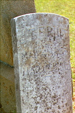
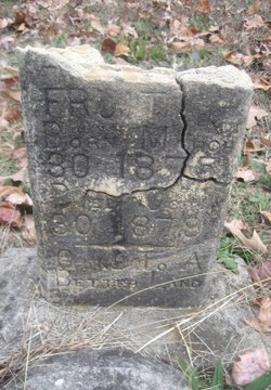
John Thomas Fruit
| Birth | : | 4 May 1858 Liberty, Randolph County, North Carolina, USA |
| Death | : | 12 Mar 1930 Hendersonville, Henderson County, North Carolina, USA |
| Burial | : | Fairview Cemetery, Liberty, Randolph County, USA |
| Coordinate | : | 35.8516998, -79.5761032 |
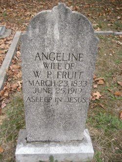
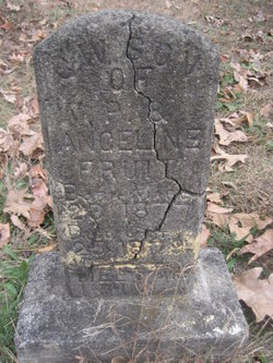
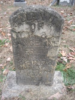
| Description | : | John Thomas Fruit was a child of William Posey Fruit and Angeline Coble Fruit. He married, first, Emma Vandelia Siler, and then later Orpha Ellen Smith. One of his children by his first wife, was Harry Alverta Fruit, my grandfather. |
frequently asked questions (FAQ):
-
Where is John Thomas Fruit's memorial?
John Thomas Fruit's memorial is located at: Fairview Cemetery, Liberty, Randolph County, USA.
-
When did John Thomas Fruit death?
John Thomas Fruit death on 12 Mar 1930 in Hendersonville, Henderson County, North Carolina, USA
-
Where are the coordinates of the John Thomas Fruit's memorial?
Latitude: 35.8516998
Longitude: -79.5761032
Family Members:
Parent

Spouse
Siblings

Children
Flowers:


Nearby Cemetories:
1. Fairview Cemetery
Liberty, Randolph County, USA
Coordinate: 35.8516998, -79.5761032
2. Amos Grove Cemetery
Liberty, Randolph County, USA
Coordinate: 35.8546982, -79.5871964
3. Saint Stephen Memorial Gardens
Liberty, Randolph County, USA
Coordinate: 35.8550750, -79.5877970
4. Bethany United Methodist Church Cemetery #2
Liberty, Randolph County, USA
Coordinate: 35.8430060, -79.5948160
5. Liberty Grove Methodist Church Cemetery
Liberty, Randolph County, USA
Coordinate: 35.8733140, -79.5709950
6. Mount Pleasant Baptist Church Cemetery
Staley, Randolph County, USA
Coordinate: 35.8144700, -79.5790000
7. Margarets Chapel Church Cemetery
Staley, Randolph County, USA
Coordinate: 35.8110940, -79.5648900
8. Hickory Grove Methodist Church Cemetery
Albright Township, Chatham County, USA
Coordinate: 35.8407560, -79.5217650
9. Olivers Chapel Cemetery
Staley, Randolph County, USA
Coordinate: 35.8060989, -79.5610962
10. McMasters Cemetery
Randolph County, USA
Coordinate: 35.8072370, -79.6021500
11. Oak Grove Baptist Church Cemetery
Snow Camp, Alamance County, USA
Coordinate: 35.8873490, -79.5330180
12. Macedonia Baptist Church Cemetery
Liberty, Randolph County, USA
Coordinate: 35.8960090, -79.6075490
13. Richland Cemetery
Liberty, Randolph County, USA
Coordinate: 35.8996315, -79.5469894
14. Melanchthon Lutheran Church Cemetery
Liberty, Randolph County, USA
Coordinate: 35.8451630, -79.6440640
15. Sandy Creek Primitive Baptist Church Cemetery
Liberty, Randolph County, USA
Coordinate: 35.8239020, -79.6406560
16. Smithwood United Church of Christ Cemetery
Guilford County, USA
Coordinate: 35.9113900, -79.5605600
17. Sandy Creek Baptist Church Cemetery
Liberty, Randolph County, USA
Coordinate: 35.8235550, -79.6429050
18. Staley City Cemetery
Staley, Randolph County, USA
Coordinate: 35.7918300, -79.5507100
19. Lineberry Family Cemetery
Staley, Randolph County, USA
Coordinate: 35.7878000, -79.5724000
20. Old Shady Grove Cemetery
Staley, Randolph County, USA
Coordinate: 35.7874985, -79.5725021
21. Pleasant Union Pilgrim Holiness Church Cemetery
Snow Camp, Alamance County, USA
Coordinate: 35.8781350, -79.5011080
22. Shady Grove Baptist Church Cemetery
Staley, Randolph County, USA
Coordinate: 35.7853800, -79.5821020
23. Hollys Chapel Pentecostal Holiness Church
Ramseur, Randolph County, USA
Coordinate: 35.7825600, -79.6048200
24. Rocky River Baptist Church Cemetery
Crutchfield Crossroads, Chatham County, USA
Coordinate: 35.8222237, -79.4875031