
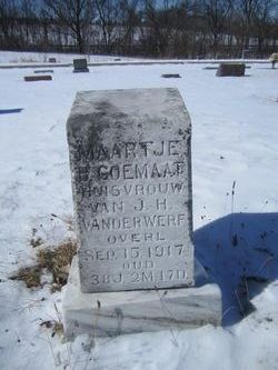
| Birth | : | 21 Sep 1909 Armour, Douglas County, South Dakota, USA |
| Death | : | 27 Oct 2007 Rapid City, Pennington County, South Dakota, USA |
| Burial | : | Kilcoy Cemetery, Kilcoy, Somerset Region, Australia |
| Coordinate | : | -26.9455258, 152.5522361 |
| Plot | : | Section 9 Lot 15 Grave 7A |
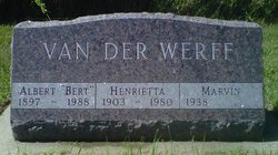
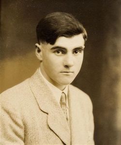
| Description | : | Obituary October 30, 2007 | Rapid City Journal (SD) Page: B2 | Section: Obituaries SPEARFISH - John VanDer Werff, 98, of Spearfish, died Saturday, October 27, 2007 at the Golden Living Center Black Hills in Rapid City, SD. John was born September 21, 1909 at Armour, SD to John and Myrtle (Goemaat) VanDer Werff. He lived most of his life in Lead, SD where he worked for the Homestake Gold Mine as a cager and painter. In 1935 John married Tena Ulmer at Miller, SD. John was a member of the Moose Lodge and Homestake Veterans,... Read More |
frequently asked questions (FAQ):
-
Where is John Vander Werff's memorial?
John Vander Werff's memorial is located at: Kilcoy Cemetery, Kilcoy, Somerset Region, Australia.
-
When did John Vander Werff death?
John Vander Werff death on 27 Oct 2007 in Rapid City, Pennington County, South Dakota, USA
-
Where are the coordinates of the John Vander Werff's memorial?
Latitude: -26.9455258
Longitude: 152.5522361
Family Members:
Parent
Spouse

Siblings
Flowers:


Nearby Cemetories:
1. Kilcoy Cemetery
Kilcoy, Somerset Region, Australia
Coordinate: -26.9455258, 152.5522361
2. Cressbrook Homestead Cemetery
Rochedale South, Logan City, Australia
Coordinate: -27.0603650, 152.4084090
3. Cressbrook Homestead Cemetery
Cressbrook, Somerset Region, Australia
Coordinate: -27.0578000, 152.4047000
4. Harlin General Cemetery
Harlin, Somerset Region, Australia
Coordinate: -26.9684600, 152.3536000
5. Toogoolawah Cemetery
Toogoolawah, Somerset Region, Australia
Coordinate: -27.0572990, 152.3794210
6. Caboonbah Church Cemetery
Caboonbah, Somerset Region, Australia
Coordinate: -27.1334046, 152.4675252
7. Woodford Cemetery
Woodford, Moreton Bay Region, Australia
Coordinate: -26.9458580, 152.7866720
8. Mount Mee Cemetery
Mount Mee, Moreton Bay Region, Australia
Coordinate: -27.0586281, 152.7549438
9. Moore-Linville Cemetery
Moore, Somerset Region, Australia
Coordinate: -26.8773340, 152.2965680
10. Fairview Cemetery
Bryden, Somerset Region, Australia
Coordinate: -27.2057004, 152.5536795
11. Bryden Catholic Cemetery
Bryden, Somerset Region, Australia
Coordinate: -27.2426026, 152.5698927
12. Peachester Cemetery
Crohamhurst, Sunshine Coast Council, Australia
Coordinate: -26.8199922, 152.8714523
13. Esk Cemetery
Esk, Somerset Region, Australia
Coordinate: -27.2394293, 152.4163463
14. Grigor Children
Glass House Mountains, Sunshine Coast Council, Australia
Coordinate: -26.9166600, 152.9228750
15. Dayboro Cemetery
Dayboro, Moreton Bay Region, Australia
Coordinate: -27.1912910, 152.8129120
16. Witta Cemetery
Witta, Sunshine Coast Council, Australia
Coordinate: -26.7061560, 152.8270080
17. Upper Caboolture Uniting Church Cemetery
Upper Caboolture, Moreton Bay Region, Australia
Coordinate: -27.1071200, 152.8945300
18. Beerburrum Cemetery
Beerburrum, Sunshine Coast Council, Australia
Coordinate: -26.9490050, 152.9547500
19. Caboolture Cemetery
Caboolture, Moreton Bay Region, Australia
Coordinate: -27.0856520, 152.9397800
20. Australia Zoo
Beerwah, Sunshine Coast Council, Australia
Coordinate: -26.8361140, 152.9615310
21. Blackbutt-Benarkin Cemetery
Blackbutt, South Burnett Region, Australia
Coordinate: -26.8877200, 152.1261340
22. St Mary's Church
Montville, Sunshine Coast Council, Australia
Coordinate: -26.6879465, 152.8926176
23. Beerwah Cemetery
Beerwah, Sunshine Coast Council, Australia
Coordinate: -26.8521020, 152.9875450
24. Flaxton Cemetery
Flaxton, Sunshine Coast Council, Australia
Coordinate: -26.6617420, 152.8731570