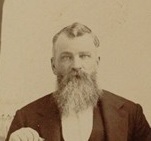
| Birth | : | 15 Mar 1847 Mill Township, Grant County, Indiana, USA |
| Death | : | 18 Nov 1934 Anthony, Harper County, Kansas, USA |
| Burial | : | Northbranch Friends Cemetery, Northbranch, Jewell County, USA |
| Coordinate | : | 39.9728300, -98.3708300 |
| Description | : | John W Lamb was born on 15 March 1847 at Grant County, Indiana.2 He was the son of Hezekiah Lamb and Hannah Small. John W Lamb died on 18 November 1934 at Anthony, Harper County, Kansas, at age 87 while at the home of his sister, Naomi Small. He was buried at North Branch Friends Cemetery, Jewell County, Kansas Contributor: Lou Ann Hawkins Frogge (46859326) |
frequently asked questions (FAQ):
-
Where is John W Lamb's memorial?
John W Lamb's memorial is located at: Northbranch Friends Cemetery, Northbranch, Jewell County, USA.
-
When did John W Lamb death?
John W Lamb death on 18 Nov 1934 in Anthony, Harper County, Kansas, USA
-
Where are the coordinates of the John W Lamb's memorial?
Latitude: 39.9728300
Longitude: -98.3708300
Family Members:
Parent
Siblings
Flowers:
Nearby Cemetories:
1. Northbranch Friends Cemetery
Northbranch, Jewell County, USA
Coordinate: 39.9728300, -98.3708300
2. Conservative Friends Cemetery
Jewell County, USA
Coordinate: 39.9448800, -98.3527500
3. Maple Grove Cemetery
Guide Rock, Webster County, USA
Coordinate: 40.0106010, -98.3482971
4. Highland Cemetery
Jewell County, USA
Coordinate: 39.9660988, -98.4300003
5. Walnut Creek Friends Cemetery
Northbranch, Jewell County, USA
Coordinate: 39.9298800, -98.3436400
6. Old Highland Township Cemetery
Jewell County, USA
Coordinate: 39.9430600, -98.4458900
7. Oak Creek Cemetery
Jewell County, USA
Coordinate: 39.9014015, -98.3918991
8. Wagoner Cemetery
Red Cloud, Webster County, USA
Coordinate: 40.0307999, -98.4488983
9. Providence Cemetery
Jewell County, USA
Coordinate: 39.8866997, -98.4008026
10. Amity Cemetery
Jewell County, USA
Coordinate: 39.9153170, -98.4673780
11. Columbia Cemetery
Guide Rock, Webster County, USA
Coordinate: 40.0499992, -98.2932968
12. Webb Hill Cemetery
Lebanon, Smith County, USA
Coordinate: 39.9520200, -98.5045200
13. Martin Cemetery
Webster County, USA
Coordinate: 40.0606003, -98.4518967
14. German Baptist Brethren Cemetery I
Burr Oak, Jewell County, USA
Coordinate: 39.8787900, -98.2955400
15. Baker Cemetery
Jewell County, USA
Coordinate: 39.8581009, -98.3617020
16. Guide Rock Cemetery
Guide Rock, Webster County, USA
Coordinate: 40.0811005, -98.3125000
17. German Baptist Brethren Cemetery II
Burr Oak, Jewell County, USA
Coordinate: 39.8720860, -98.2786470
18. Shaffer Cemetery
Mankato, Jewell County, USA
Coordinate: 39.9514008, -98.2118988
19. German Kellner Cemetery
Webber, Jewell County, USA
Coordinate: 39.9437828, -98.2119141
20. Burr Oak Cemetery
Burr Oak, Jewell County, USA
Coordinate: 39.8652992, -98.2846985
21. Amboy Cemetery
Amboy, Webster County, USA
Coordinate: 40.1003150, -98.4297540
22. Gust Cemetery
Webster County, USA
Coordinate: 40.0172005, -98.5421982
23. Salem Cemetery
Esbon, Jewell County, USA
Coordinate: 39.8755989, -98.5006027
24. Cleveland Cemetery
Webber, Jewell County, USA
Coordinate: 39.9305992, -98.1939011


