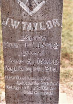
John Wade Taylor
| Birth | : | 14 Feb 1843 Henry County, Tennessee, USA |
| Death | : | 5 Apr 1900 Clay County, Arkansas, USA |
| Burial | : | Marys Chapel Cemetery, Rector, Clay County, USA |
| Coordinate | : | 36.2921982, -90.2830963 |
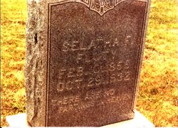
| Description | : | John Wade Taylor was the son of James W. Taylor and Jane McBride. John Wade Taylor enlisted in the 5th Tennessee Infantry, CSA, in Henry County, Tennessee in 1861. He must have served with distinction as he was promoted to Sergeant by the end of the war. This unit was engaged in several major battles. See http://www.cwnorthandsouth.com/5thTNHst.htm for more information. He married Malinda Jane Brake in 1866 in Henry County, Tennessee, and after her passing he married Selatha Francisco Allen Martindale in Clay County in 1877. |
frequently asked questions (FAQ):
-
Where is John Wade Taylor's memorial?
John Wade Taylor's memorial is located at: Marys Chapel Cemetery, Rector, Clay County, USA.
-
When did John Wade Taylor death?
John Wade Taylor death on 5 Apr 1900 in Clay County, Arkansas, USA
-
Where are the coordinates of the John Wade Taylor's memorial?
Latitude: 36.2921982
Longitude: -90.2830963
Family Members:
Spouse
Children
Flowers:
Nearby Cemetories:
1. Marys Chapel Cemetery
Rector, Clay County, USA
Coordinate: 36.2921982, -90.2830963
2. Hillsboro Cemetery
Rector, Clay County, USA
Coordinate: 36.2975883, -90.2605820
3. Blooming Grove Cemetery
Clay County, USA
Coordinate: 36.3147011, -90.2913971
4. Woodland Heights Cemetery
Rector, Clay County, USA
Coordinate: 36.2724991, -90.3039017
5. Scatterville Cemetery
Rector, Clay County, USA
Coordinate: 36.2813683, -90.3131104
6. Liberty Hill Cemetery
Boydsville, Clay County, USA
Coordinate: 36.3280983, -90.3182983
7. Travillian Cemetery
Clay County, USA
Coordinate: 36.3382988, -90.2842026
8. Parks Cemetery
Rector, Clay County, USA
Coordinate: 36.2619934, -90.3266754
9. Mound Cemetery
Clay County, USA
Coordinate: 36.2737312, -90.3426285
10. Hargrave Parish Church
Hargrave Corner, Clay County, USA
Coordinate: 36.2590598, -90.2290688
11. Mitchell Cemetery
Greenway, Clay County, USA
Coordinate: 36.3352013, -90.2378464
12. Lone Grave
Clay County, USA
Coordinate: 36.3358002, -90.3331070
13. Winston Cemetery
Clay County, USA
Coordinate: 36.3464012, -90.2382965
14. Shannon Cemetery
Clay County, USA
Coordinate: 36.2982483, -90.3639374
15. Ebenezer Cemetery
Clay County, USA
Coordinate: 36.2887383, -90.3643570
16. Pleasant Grove Cemetery
Hopewell, Greene County, USA
Coordinate: 36.2543983, -90.3630981
17. Underwood Cemetery
Clay County, USA
Coordinate: 36.3656006, -90.2639008
18. Johnson Chapel Cemetery
Clay County, USA
Coordinate: 36.3383900, -90.3572400
19. Mars Hill Cemetery
Crockett, Clay County, USA
Coordinate: 36.3624992, -90.3275604
20. Leonard Cemetery
Leonard, Clay County, USA
Coordinate: 36.2164001, -90.2481003
21. Williams Cemetery
Greenway, Clay County, USA
Coordinate: 36.3741989, -90.2686005
22. Salem Cemetery
Rector, Clay County, USA
Coordinate: 36.3208008, -90.3818970
23. Purcell Cemetery
Rector, Clay County, USA
Coordinate: 36.2602997, -90.3910980
24. Hardin Chapel Cemetery
Clay County, USA
Coordinate: 36.3755989, -90.3405991

