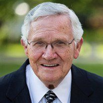
| Birth | : | 16 Feb 1926 Rison, Cleveland County, Arkansas, USA |
| Death | : | 11 Jul 2004 Little Rock, Pulaski County, Arkansas, USA |
| Burial | : | Mountain View Cemetery, Shrewsbury, Worcester County, USA |
| Coordinate | : | 42.2999306, -71.7147598 |
| Description | : | LITTLE ROCK -- John Walter Elrod, 78, of Little Rock, formerly of Rison, died Sunday. He was born Feb. 16, 1926, at Rison, a son of the late Searcy Elrod and Frances Sadler Elrod. He served as a bombardier in the Army Air Corps During World War II. He was a graduate of the University of Arkansas School of Law where he was editor of the Law Review. He practiced law at Rison and managed Elrod Company, a family owned business that dealt in wood products and oil and gas production. He was a member of the Rison Baptist Church where he... Read More |
frequently asked questions (FAQ):
-
Where is John Walter Elrod's memorial?
John Walter Elrod's memorial is located at: Mountain View Cemetery, Shrewsbury, Worcester County, USA.
-
When did John Walter Elrod death?
John Walter Elrod death on 11 Jul 2004 in Little Rock, Pulaski County, Arkansas, USA
-
Where are the coordinates of the John Walter Elrod's memorial?
Latitude: 42.2999306
Longitude: -71.7147598
Family Members:
Parent
Spouse
Siblings
Flowers:
Nearby Cemetories:
1. Mountain View Cemetery
Shrewsbury, Worcester County, USA
Coordinate: 42.2999306, -71.7147598
2. West Main Street Cemetery
Shrewsbury, Worcester County, USA
Coordinate: 42.2912600, -71.7420000
3. Hillside West Cemetery
Shrewsbury, Worcester County, USA
Coordinate: 42.2692600, -71.7236100
4. Hillside East Cemetery
Shrewsbury, Worcester County, USA
Coordinate: 42.2663850, -71.7225270
5. Saint Anne's Cemetery
Shrewsbury, Worcester County, USA
Coordinate: 42.2746300, -71.7485400
6. Notre Dame du Lac Cemetery
Worcester, Worcester County, USA
Coordinate: 42.2910170, -71.7681030
7. Grove Street Burial Ground
Shrewsbury, Worcester County, USA
Coordinate: 42.2578090, -71.7173770
8. Grafton State Hospital Memorial Cemetery
Shrewsbury, Worcester County, USA
Coordinate: 42.2518900, -71.6854200
9. Old Burial Ground
Boylston, Worcester County, USA
Coordinate: 42.3515700, -71.7355300
10. Howard Street Cemetery
Northborough, Worcester County, USA
Coordinate: 42.3249000, -71.6475400
11. First Burying Place
Northborough, Worcester County, USA
Coordinate: 42.3044100, -71.6388400
12. Pine Grove Cemetery
Boylston, Worcester County, USA
Coordinate: 42.3582993, -71.7431030
13. Pine Grove Cemetery
Grafton, Worcester County, USA
Coordinate: 42.2346992, -71.7042007
14. Old Burial Place
Worcester, Worcester County, USA
Coordinate: 42.2679000, -71.7961300
15. Worcester Rural Cemetery
Worcester, Worcester County, USA
Coordinate: 42.2803001, -71.8035965
16. Mechanic Street Burying Ground (Defunct)
Worcester, Worcester County, USA
Coordinate: 42.2635800, -71.7981900
17. Adam El-Khishin Meditation Area
Worcester, Worcester County, USA
Coordinate: 42.2755600, -71.8090900
18. Worcester Common Burial Ground
Worcester, Worcester County, USA
Coordinate: 42.2621100, -71.8006800
19. Mount Vernon Cemetery
West Boylston, Worcester County, USA
Coordinate: 42.3634650, -71.7804030
20. Memorial Cemetery
Westborough, Worcester County, USA
Coordinate: 42.2686800, -71.6142600
21. Beaman Cemetery
West Boylston, Worcester County, USA
Coordinate: 42.3649590, -71.7803600
22. Midland Cemetery
Westborough, Worcester County, USA
Coordinate: 42.2661630, -71.6119770
23. Pine Grove Cemetery
Westborough, Worcester County, USA
Coordinate: 42.2647018, -71.6082993
24. Mary Goodnow Gravesite
Northborough, Worcester County, USA
Coordinate: 42.3349900, -71.6054100


