

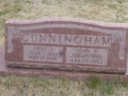
John William Cunningham
| Birth | : | 26 Jan 1866 Irondale, Washington County, Missouri, USA |
| Death | : | 27 Mar 1954 Bonne Terre, St. Francois County, Missouri, USA |
| Burial | : | Mount Collins Cemetery, Tionesta, Forest County, USA |
| Coordinate | : | 41.4902992, -79.4621964 |
| Description | : | Husband of Anna Letha Westover Son of Arthur Cunningham & Emma Renfro |
frequently asked questions (FAQ):
-
Where is John William Cunningham's memorial?
John William Cunningham's memorial is located at: Mount Collins Cemetery, Tionesta, Forest County, USA.
-
When did John William Cunningham death?
John William Cunningham death on 27 Mar 1954 in Bonne Terre, St. Francois County, Missouri, USA
-
Where are the coordinates of the John William Cunningham's memorial?
Latitude: 41.4902992
Longitude: -79.4621964
Family Members:
Spouse
Children
Flowers:


Nearby Cemetories:
1. Mount Collins Cemetery
Tionesta, Forest County, USA
Coordinate: 41.4902992, -79.4621964
2. Old Methodist Cemetery
Tionesta, Forest County, USA
Coordinate: 41.4908829, -79.4561005
3. Riverside Cemetery
Tionesta, Forest County, USA
Coordinate: 41.4999504, -79.4566193
4. Holeman Cemetery
Forest County, USA
Coordinate: 41.4757996, -79.5030975
5. Connely Burial Ground
Stewart Run, Forest County, USA
Coordinate: 41.5256080, -79.5095160
6. Van Giesen Cemetery
President, Venango County, USA
Coordinate: 41.4696000, -79.5387000
7. Mount Zion Lutheran Cemetery
Kiser Corners, Forest County, USA
Coordinate: 41.5084000, -79.3731155
8. Stewart Run Cemetery
Stewart Run, Forest County, USA
Coordinate: 41.5569000, -79.4973000
9. Mount Zion Community Cemetery
Tionesta, Forest County, USA
Coordinate: 41.4201000, -79.4203000
10. Asbury Chapel Cemetery
Venango County, USA
Coordinate: 41.5558014, -79.5207977
11. President Cemetery
President, Venango County, USA
Coordinate: 41.4578370, -79.5583370
12. Starr Cemetery
Church Hill, Forest County, USA
Coordinate: 41.5255165, -79.3642349
13. Holmden Cemetery
Pithole City, Venango County, USA
Coordinate: 41.5214720, -79.5668050
14. Pithole Cemetery
Pithole City, Venango County, USA
Coordinate: 41.5214720, -79.5668060
15. Siggins Family Cemetery
West Hickory, Forest County, USA
Coordinate: 41.5673940, -79.4132570
16. West Hickory Cemetery
Forest County, USA
Coordinate: 41.5726000, -79.4128000
17. Wolfs Corners Cemetery
Wolfs Corners, Clarion County, USA
Coordinate: 41.4177000, -79.3883000
18. Sparks Cemetery
Eagle Rock, Venango County, USA
Coordinate: 41.4691650, -79.5837590
19. Eagle Rock Cemetery
Venango County, USA
Coordinate: 41.4524910, -79.5766570
20. Amity Cemetery
Newmansville, Clarion County, USA
Coordinate: 41.4231000, -79.3697000
21. Church Hill Cemetery
Hickory Township, Forest County, USA
Coordinate: 41.5654000, -79.3810000
22. McCalmont Cemetery
President, Venango County, USA
Coordinate: 41.4066000, -79.5314000
23. Concord Cemetery
Pleasantville, Venango County, USA
Coordinate: 41.5667000, -79.5483017
24. Prather Family Cemetery
East Hickory, Forest County, USA
Coordinate: 41.5797539, -79.4001694