John WILLIAM Hohl
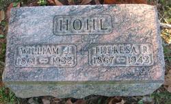
| Birth | : | 3 Sep 1861 Medina County, Ohio, USA |
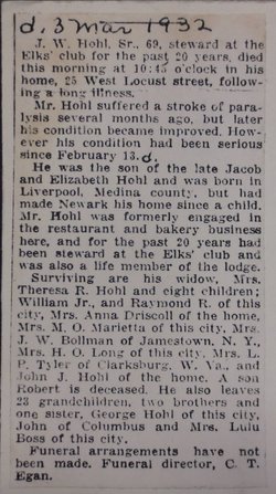
| Death | : | 3 Mar 1932 Newark, Licking County, Ohio, USA |
| Burial | : | Waikumete Cemetery & Crematorium, Glen Eden, Auckland Council, New Zealand |
| Coordinate | : | -36.9025130, 174.6539610 |
| Plot | : | Sorrowful Mother - Lot 366 - 11 |
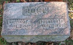
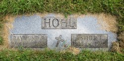
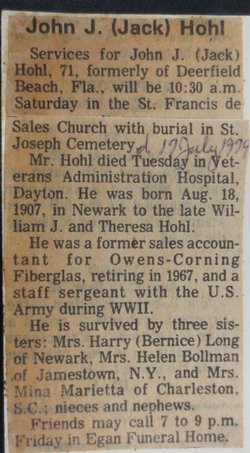
| Description | : | **NOTE** The tombstone is engraved William J Hohl. Other Children: --William Jr Hohl (Joseph William?) --Mrs. JW Hohl Bollman --Mrs. HO Hohl Long --Robert Hohl (deceased) Brothers and Sister: --Goerge Hohl --John Hohl --Lulu Hohl Boss According to files in the Licking County Genealogical Society, he was the son of George JACOB and Elizabeth Miller Hohl. His name was J(ohn) W(illiam) Hohl and he was born on Sept 3, 1861 (or 1862). |
frequently asked questions (FAQ):
-
Where is John WILLIAM Hohl's memorial?
John WILLIAM Hohl's memorial is located at: Waikumete Cemetery & Crematorium, Glen Eden, Auckland Council, New Zealand.
-
When did John WILLIAM Hohl death?
John WILLIAM Hohl death on 3 Mar 1932 in Newark, Licking County, Ohio, USA
-
Where are the coordinates of the John WILLIAM Hohl's memorial?
Latitude: -36.9025130
Longitude: 174.6539610
Family Members:
Parent
Spouse
Siblings
Children
Flowers:
Nearby Cemetories:
1. Waikumete Cemetery & Crematorium
Glen Eden, Auckland Council, New Zealand
Coordinate: -36.9025130, 174.6539610
2. Auckland Provincial Memorial
Glen Eden, Auckland Council, New Zealand
Coordinate: -36.9020700, 174.6548500
3. Oratia Cemetery
Oratia, Auckland Council, New Zealand
Coordinate: -36.9108800, 174.6218900
4. Settlers Cemetery
Oratia, Auckland Council, New Zealand
Coordinate: -36.9108770, 174.6218870
5. George Maxwell Memorial Cemetery
Avondale, Auckland Council, New Zealand
Coordinate: -36.8890320, 174.6849320
6. Saint Ninians Churchyard
Avondale, Auckland Council, New Zealand
Coordinate: -36.8994510, 174.6966690
7. Oratia Combined Church Cemetery
Oratia, Auckland Council, New Zealand
Coordinate: -36.9196396, 174.6119362
8. Swanson Cemetery
Swanson, Auckland Council, New Zealand
Coordinate: -36.8718400, 174.5836200
9. St. Luke's Anglican Church Cemetery
Mount Albert, Auckland Council, New Zealand
Coordinate: -36.8785540, 174.7290400
10. Hillsborough Cemetery
Hillsborough, Auckland Council, New Zealand
Coordinate: -36.9246600, 174.7524030
11. Saint Andrew's Churchyard
Epsom, Auckland Council, New Zealand
Coordinate: -36.8937200, 174.7654100
12. Mount Eden Stockade Cemetery
Mount Eden, Auckland Council, New Zealand
Coordinate: -36.8678370, 174.7666430
13. Symonds Street Cemetery
Auckland, Auckland Council, New Zealand
Coordinate: -36.8582828, 174.7636628
14. Hobsonville Church and Settlers' Cemetery
Hobsonville, Auckland Council, New Zealand
Coordinate: -36.8000500, 174.6551800
15. St Mark's Anglican Church Cemetery
Remuera, Auckland Council, New Zealand
Coordinate: -36.8729300, 174.7801600
16. St. Peter's Anglican Cemetery
Ōnehunga, Auckland Council, New Zealand
Coordinate: -36.9227113, 174.7847550
17. Our Lady of the Assumption Catholic Church
Ōnehunga, Auckland Council, New Zealand
Coordinate: -36.9223690, 174.7884530
18. Onehunga Catholic Cemetery
Ōnehunga, Auckland Council, New Zealand
Coordinate: -36.9224360, 174.7884560
19. Mangere Piriti Urupā St. James Churchyard
Mangere, Auckland Council, New Zealand
Coordinate: -36.9418970, 174.7835260
20. Pompallier Cemetery
Birkenhead, Auckland Council, New Zealand
Coordinate: -36.8036900, 174.7251200
21. Waikaraka Cemetery
Ōnehunga, Auckland Council, New Zealand
Coordinate: -36.9297140, 174.7967170
22. Birkenhead-Glenfield Cemetery
Birkenhead, Auckland Council, New Zealand
Coordinate: -36.7989000, 174.7234700
23. St. Stephen's Churchyard
Auckland, Auckland Council, New Zealand
Coordinate: -36.8504860, 174.7899970
24. Mangere Lawn Cemetery
Mangere, Auckland Council, New Zealand
Coordinate: -36.9626150, 174.7857000

