
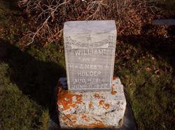
John William Holder
| Birth | : | 11 Aug 1914 |
| Death | : | 11 Jun 1922 Lincoln County, Montana, USA |
| Burial | : | Ladner Cemetery, Stanwood, Mecosta County, USA |
| Coordinate | : | 43.6206017, -85.4918976 |
| Description | : | Montana, Death Index Name: John W Holder Death Date: 11 Jun 1922 Death County: Lincoln |
frequently asked questions (FAQ):
-
Where is John William Holder's memorial?
John William Holder's memorial is located at: Ladner Cemetery, Stanwood, Mecosta County, USA.
-
When did John William Holder death?
John William Holder death on 11 Jun 1922 in Lincoln County, Montana, USA
-
Where are the coordinates of the John William Holder's memorial?
Latitude: 43.6206017
Longitude: -85.4918976
Family Members:
Parent
Siblings
Flowers:


Nearby Cemetories:
1. Ladner Cemetery
Stanwood, Mecosta County, USA
Coordinate: 43.6206017, -85.4918976
2. Fairview Cemetery
Mecosta Township, Mecosta County, USA
Coordinate: 43.5891991, -85.5335999
3. Zions Cemetery
Mecosta Township, Mecosta County, USA
Coordinate: 43.5696983, -85.5100021
4. Stanwood Cemetery
Stanwood, Mecosta County, USA
Coordinate: 43.5769691, -85.4444885
5. Mecosta County Farm Cemetery
Mecosta Township, Mecosta County, USA
Coordinate: 43.5738200, -85.4447300
6. Pine Plains Cemetery
Big Rapids, Mecosta County, USA
Coordinate: 43.6680984, -85.4436035
7. Saint Andrews Episcopal Church Columbarium
Big Rapids, Mecosta County, USA
Coordinate: 43.6946130, -85.4835020
8. Highland View Cemetery
Big Rapids, Mecosta County, USA
Coordinate: 43.7032318, -85.4905319
9. Olin Cemetery
Stanwood, Mecosta County, USA
Coordinate: 43.5879000, -85.3719500
10. Mount Carmel Cemetery
Big Rapids, Mecosta County, USA
Coordinate: 43.7146187, -85.5154572
11. Goodwell Cemetery
Goodwell Township, Newaygo County, USA
Coordinate: 43.5992012, -85.6235962
12. Quigley Cemetery
Deerfield Township, Mecosta County, USA
Coordinate: 43.5536003, -85.3930969
13. West Aetna Cemetery
Aetna Township, Mecosta County, USA
Coordinate: 43.5367660, -85.5623060
14. VanGilder Cemetery
Big Rapids Township, Mecosta County, USA
Coordinate: 43.7144508, -85.5587769
15. Higbee Cemetery
Stanwood, Mecosta County, USA
Coordinate: 43.5394707, -85.3921890
16. Holt Cemetery
Morley, Mecosta County, USA
Coordinate: 43.5130997, -85.4332962
17. Hungerford Cemetery
Norwich Township, Newaygo County, USA
Coordinate: 43.6935997, -85.6231003
18. West Cemetery
Big Rapids, Mecosta County, USA
Coordinate: 43.7421989, -85.4978027
19. Rodney Cemetery
Rodney, Mecosta County, USA
Coordinate: 43.6703491, -85.3264923
20. Aetna Township Cemetery
Morley, Mecosta County, USA
Coordinate: 43.4906006, -85.4597015
21. Saint Apollonia Cemetery
Morley, Mecosta County, USA
Coordinate: 43.4907990, -85.4278030
22. 160th Avenue South Cemetery
Big Rapids, Mecosta County, USA
Coordinate: 43.7436111, -85.4038889
23. Merrill Township Cemetery
Brohman, Newaygo County, USA
Coordinate: 43.6650000, -85.6770000
24. Woodville Cemetery
Woodville, Newaygo County, USA
Coordinate: 43.6677780, -85.6808330