

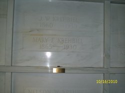
John William “J W” Krehbiel
| Birth | : | 10 Aug 1860 Summerfield, St. Clair County, Illinois, USA |
| Death | : | 6 Jan 1939 Halstead, Harvey County, Kansas, USA |
| Burial | : | Brooklawn Cemetery, Walker, Kent County, USA |
| Coordinate | : | 43.0280991, -85.7300034 |
frequently asked questions (FAQ):
-
Where is John William “J W” Krehbiel's memorial?
John William “J W” Krehbiel's memorial is located at: Brooklawn Cemetery, Walker, Kent County, USA.
-
When did John William “J W” Krehbiel death?
John William “J W” Krehbiel death on 6 Jan 1939 in Halstead, Harvey County, Kansas, USA
-
Where are the coordinates of the John William “J W” Krehbiel's memorial?
Latitude: 43.0280991
Longitude: -85.7300034
Family Members:
Parent

Spouse

Siblings
Children
Flowers:


Nearby Cemetories:
1. Brooklawn Cemetery
Walker, Kent County, USA
Coordinate: 43.0280991, -85.7300034
2. Holy Trinity Cemetery
Alpine Township, Kent County, USA
Coordinate: 43.0511017, -85.6992035
3. Holy Cross Cemetery
Grand Rapids, Kent County, USA
Coordinate: 42.9953003, -85.7153015
4. Saints Peter and Paul Cemetery
Grand Rapids, Kent County, USA
Coordinate: 42.9963890, -85.6997220
5. Achim Cemetery
Grand Rapids, Kent County, USA
Coordinate: 42.9961014, -85.6994019
6. Lithuanian Freedom Cemetery
Grand Rapids, Kent County, USA
Coordinate: 42.9956430, -85.6991170
7. Washington Park Memorial Gardens
Grand Rapids, Kent County, USA
Coordinate: 42.9944000, -85.7007980
8. Greenwood Cemetery
Grand Rapids, Kent County, USA
Coordinate: 42.9892006, -85.7055969
9. Mill Creek Cemetery
Walker, Kent County, USA
Coordinate: 43.0288890, -85.6705560
10. Alpine Center Cemetery
Comstock Park, Kent County, USA
Coordinate: 43.0724983, -85.7285995
11. United Church of Christ Cemetery
Comstock Park, Kent County, USA
Coordinate: 43.0359210, -85.6684260
12. Mount Calvary Cemetery
Grand Rapids, Kent County, USA
Coordinate: 42.9846992, -85.7043991
13. Saur-Cross Cemetery
Walker, Kent County, USA
Coordinate: 43.0738890, -85.7569440
14. Grand Rapids Veterans Home Cemetery
Grand Rapids, Kent County, USA
Coordinate: 43.0182915, -85.6588898
15. Saint Pauls Anglican Church Columbarium
Grand Rapids, Kent County, USA
Coordinate: 42.9711200, -85.7321700
16. Pine Grove Cemetery
Comstock Park, Kent County, USA
Coordinate: 43.0757700, -85.6827600
17. Second Congregational UCC Memorial Garden
Grand Rapids, Kent County, USA
Coordinate: 43.0032900, -85.6549900
18. Saint Andrews Episcopal Gardens
Grand Rapids, Kent County, USA
Coordinate: 43.0142030, -85.6430840
19. Marne Cemetery
Marne, Ottawa County, USA
Coordinate: 43.0309810, -85.8238630
20. Fairplains Cemetery
Grand Rapids, Kent County, USA
Coordinate: 43.0005989, -85.6421967
21. Rosedale Memorial Park
Tallmadge Township, Ottawa County, USA
Coordinate: 42.9721160, -85.7876870
22. Gerald R Ford Museum
Grand Rapids, Kent County, USA
Coordinate: 42.9668140, -85.6771000
23. Garden of the Pines
Grand Rapids, Kent County, USA
Coordinate: 43.0422710, -85.6279260
24. First United Methodist Church Columbarium
Grand Rapids, Kent County, USA
Coordinate: 42.9634200, -85.6633300