
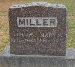
John William Miller
| Birth | : | 26 Aug 1857 Olean, Miller County, Missouri, USA |
| Death | : | 30 Oct 1950 Summersville, Shannon County, Missouri, USA |
| Burial | : | Olean Cemetery, Olean, Miller County, USA |
| Coordinate | : | 38.4131012, -92.5413971 |
| Description | : | Unknown Newspaper, October 1950 John W. Miller, father of Mrs. Walter Hayes of Eldon, died at his home near Summersville, Mo., Monday, Oct. 30. Burial was in the Olean Cemetery Thursday, Nov. 2. Funeral services were conducted that morning at the Christian Church in Summersville by Mr. Lloyd Cochran. Mr. Miller formerly resided in the Olean community where he operated a farm at one time. Beofre going o Summersville he lived in Oregon and Colorado for several years. About 30 years ago he moved to Texas County where he operated a large cattle ranch near Summersville... Read More |
frequently asked questions (FAQ):
-
Where is John William Miller's memorial?
John William Miller's memorial is located at: Olean Cemetery, Olean, Miller County, USA.
-
When did John William Miller death?
John William Miller death on 30 Oct 1950 in Summersville, Shannon County, Missouri, USA
-
Where are the coordinates of the John William Miller's memorial?
Latitude: 38.4131012
Longitude: -92.5413971
Family Members:
Parent
Spouse

Siblings
Children
Flowers:


Nearby Cemetories:
1. Olean Cemetery
Olean, Miller County, USA
Coordinate: 38.4131012, -92.5413971
2. Green Ridge Baptist Church Cemetery
Eldon, Miller County, USA
Coordinate: 38.4116200, -92.5645700
3. Etter-Walker Cemetery
Burris Fork, Moniteau County, USA
Coordinate: 38.4333700, -92.5525400
4. Walker Cemetery
Moniteau County, USA
Coordinate: 38.4338989, -92.5522003
5. Farris Cemetery
Moniteau County, USA
Coordinate: 38.4369900, -92.5380000
6. Allen Cemetery
Olean, Miller County, USA
Coordinate: 38.4150009, -92.5008011
7. Jackson Chapel Methodist Church Cemetery
California, Moniteau County, USA
Coordinate: 38.4447900, -92.5286500
8. Gray Cemetery
Moniteau County, USA
Coordinate: 38.4536018, -92.5456009
9. Hite Cemetery
Miller County, USA
Coordinate: 38.4039001, -92.5935974
10. Mount Pleasant Cemetery
Eldon, Miller County, USA
Coordinate: 38.3667700, -92.5300800
11. Salem Cemetery
Saline Township, Miller County, USA
Coordinate: 38.3691232, -92.5697260
12. Salem Cemetery
Eldon, Miller County, USA
Coordinate: 38.3697014, -92.5714035
13. Mount Vernon Cemetery
Eldon, Miller County, USA
Coordinate: 38.3624992, -92.5606003
14. Bruce-Lewis-McGahan Cemetery
Enon, Moniteau County, USA
Coordinate: 38.4667500, -92.5172100
15. Rock Enon Cemetery
Miller County, USA
Coordinate: 38.4668400, -92.5170700
16. Eldon Cemetery
Eldon, Miller County, USA
Coordinate: 38.3642006, -92.5868988
17. Phillips Cemetery
High Point, Moniteau County, USA
Coordinate: 38.4430300, -92.6125300
18. Colburn Cemetery
Eldon, Miller County, USA
Coordinate: 38.4246300, -92.6275500
19. Depp Cemetery
High Point, Moniteau County, USA
Coordinate: 38.4776400, -92.5818500
20. High Point Cemetery
High Point, Moniteau County, USA
Coordinate: 38.4817009, -92.5757980
21. Phillips Cemetery
Barnett, Morgan County, USA
Coordinate: 38.4227982, -92.6367035
22. Matheis Cemetery
Russellville, Cole County, USA
Coordinate: 38.4571800, -92.4491600
23. United Baptist Church Cemetery
High Point, Moniteau County, USA
Coordinate: 38.4962200, -92.5856800
24. Karnes-Carney-Henderson Cemetery
Burris Fork, Moniteau County, USA
Coordinate: 38.4992100, -92.5007510