
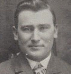
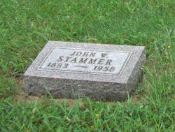
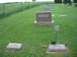
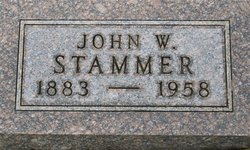
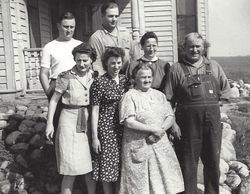
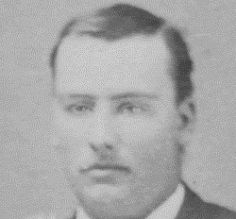
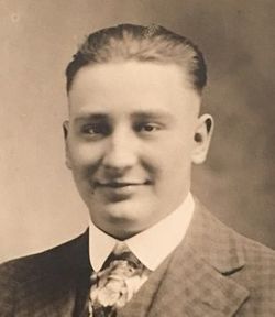
John William Stammer
| Birth | : | 17 Jan 1883 Casey, Guthrie County, Iowa, USA |
| Death | : | 19 Sep 1958 Faulkton, Faulk County, South Dakota, USA |
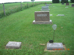
| Burial | : | St George Churchyard, Beckington, Mendip District, England |
| Coordinate | : | 51.2635260, -2.2856810 |
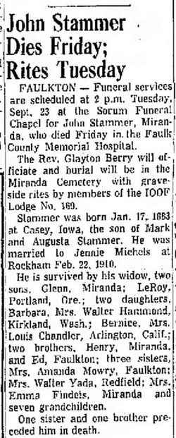
| Description | : | The Huronite & The Daily Plainsman Sept. 21, 1958 John Stammer Dies Friday; Rites Tuesday FAULKTON - Funeral services are scheduled at 2 p.m. Tuesday, Sept. 23 at the Sorum Funeral Chapel for John Stammer, Miranda, who died Friday in the Faulk County Memorial Hospital. The Rev. Glayton Berry will officiate and burial will be in the Miranda Cemetery with graveside rites by members of the IOOF Lodge NO. 169. Stammer was born Jan. 17, 1883 at Casey, Iowa, the son of Mark and Augusta Stammer. He was married to Jennie Michels at Rockham Feb. 22, 1910. He is survived by his widow, two sons,... Read More |
frequently asked questions (FAQ):
-
Where is John William Stammer's memorial?
John William Stammer's memorial is located at: St George Churchyard, Beckington, Mendip District, England.
-
When did John William Stammer death?
John William Stammer death on 19 Sep 1958 in Faulkton, Faulk County, South Dakota, USA
-
Where are the coordinates of the John William Stammer's memorial?
Latitude: 51.2635260
Longitude: -2.2856810
Family Members:
Parent
Spouse
Siblings

Children

Flowers:


Nearby Cemetories:
1. St George Churchyard
Beckington, Mendip District, England
Coordinate: 51.2635260, -2.2856810
2. Beckington Baptist Chapel Burial Ground
Beckington, Mendip District, England
Coordinate: 51.2610760, -2.2897000
3. St Lawrence Churchyard
Rode, Mendip District, England
Coordinate: 51.2792750, -2.2765370
4. All Saints Churchyard
Lullington, Mendip District, England
Coordinate: 51.2661940, -2.3121800
5. St. Mary's Berkley
Berkley, Mendip District, England
Coordinate: 51.2435080, -2.2720990
6. Christ Church Churchyard
Rode, Mendip District, England
Coordinate: 51.2861620, -2.2790890
7. St. Lawrence Churchyard
Woolverton, Mendip District, England
Coordinate: 51.2851540, -2.3021790
8. St Mary's Churchyard
Laverton, Mendip District, England
Coordinate: 51.2757380, -2.3195910
9. St Mary the Virgin Churchyard
Orchardleigh, Mendip District, England
Coordinate: 51.2576210, -2.3259440
10. All Saints Churchyard
Rodden, Mendip District, England
Coordinate: 51.2283600, -2.2892740
11. All Saints Churchyard
Tellisford, Mendip District, England
Coordinate: 51.2997270, -2.2877180
12. East Hill Cemetery
Frome, Mendip District, England
Coordinate: 51.2275940, -2.3030250
13. East Hill
Frome St Quintin, West Dorset District, England
Coordinate: 51.2272132, -2.3024896
14. Frome Dissenters' Cemetery
Frome, Mendip District, England
Coordinate: 51.2317000, -2.3215000
15. Holy Trinity Church
Frome, Mendip District, England
Coordinate: 51.2341720, -2.3275820
16. St. John the Baptist Churchyard
Frome, Mendip District, England
Coordinate: 51.2296780, -2.3209480
17. Sheppards Barton Meeting House Burial Ground
Frome, Mendip District, England
Coordinate: 51.2300570, -2.3247620
18. Saint Michael & All Angels Churchyard
Buckland Dinham, Mendip District, England
Coordinate: 51.2600540, -2.3522580
19. Christ Church Churchyard
Frome, Mendip District, England
Coordinate: 51.2295340, -2.3260130
20. Norton St. Philip Churchyard
Norton St Philip, Mendip District, England
Coordinate: 51.3001680, -2.3279700
21. St. Margaret Churchyard Extension
Corsley, Wiltshire Unitary Authority, England
Coordinate: 51.2191491, -2.2469419
22. St Leonard Churchyard
Farleigh Hungerford, Mendip District, England
Coordinate: 51.3155390, -2.2884820
23. Penknap Providence Baptist Chapelyard
Dilton Marsh, Wiltshire Unitary Authority, England
Coordinate: 51.2467910, -2.2059510
24. Saint Mary Magdalene Churchyard
Great Elm, Mendip District, England
Coordinate: 51.2426040, -2.3647230