
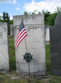
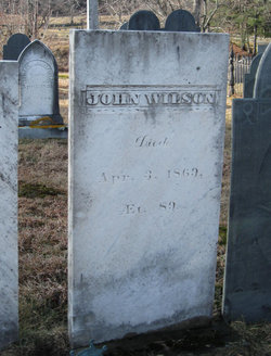
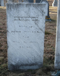
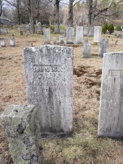
John Wilson
| Birth | : | 28 May 1780 |
| Death | : | 3 Apr 1869 |
| Burial | : | New Hope Cemetery, Marion, Cole County, USA |
| Coordinate | : | 38.6955872, -92.3943558 |
| Plot | : | C229 |
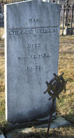
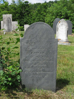
| Description | : | He succeeded to his father's farm, and there spent his life. Married: Anna Dale Holt of Wilton, Dec 31, 1805 Children: John, John Gardner, Ann, Supply Carter, Joseph Addison, Betsey, Betsey Adaline, George, Edward, Edwin, Charles, Horace Woodbury, George Edwin. |
frequently asked questions (FAQ):
-
Where is John Wilson's memorial?
John Wilson's memorial is located at: New Hope Cemetery, Marion, Cole County, USA.
-
When did John Wilson death?
John Wilson death on 3 Apr 1869 in
-
Where are the coordinates of the John Wilson's memorial?
Latitude: 38.6955872
Longitude: -92.3943558
Family Members:
Parent
Spouse
Siblings
Children
Flowers:


Nearby Cemetories:
1. New Hope Cemetery
Marion, Cole County, USA
Coordinate: 38.6955872, -92.3943558
2. Old Marion Cemetery
Marion, Cole County, USA
Coordinate: 38.7065506, -92.3792801
3. Mary Ann Williams Cemetery
California, Moniteau County, USA
Coordinate: 38.6988200, -92.4327900
4. Hickman Cemetery
Marion, Cole County, USA
Coordinate: 38.6776300, -92.3595600
5. Shull Cemetery
Moniteau County, USA
Coordinate: 38.7296982, -92.3972015
6. Shull Cemetery
Cole County, USA
Coordinate: 38.7296982, -92.3974991
7. Bailey Farm Cemetery
Marion, Cole County, USA
Coordinate: 38.6680330, -92.3553800
8. Shiloh Christian Church Cemetery
California, Moniteau County, USA
Coordinate: 38.6951800, -92.4502300
9. Cook Cemetery
Moniteau County, USA
Coordinate: 38.7393990, -92.4080963
10. Knife Cemetery
Marion, Cole County, USA
Coordinate: 38.6681200, -92.3417300
11. Goshen Primitive Baptist Church Cemetery
Wilton, Boone County, USA
Coordinate: 38.7346600, -92.3550000
12. Sweetwater Cemetery
Moniteau County, USA
Coordinate: 38.6567001, -92.4411011
13. Kubli Chapel Cemetery
Jamestown, Moniteau County, USA
Coordinate: 38.7417300, -92.4295200
14. John D. Williams Cemetery
Sandy Hook, Moniteau County, USA
Coordinate: 38.7545600, -92.4098800
15. New Hope Cemetery
California, Moniteau County, USA
Coordinate: 38.6792800, -92.4774100
16. Steeley Cemetery
Elston, Cole County, USA
Coordinate: 38.6530883, -92.3282420
17. Friedens Cemetery
Hartsburg, Boone County, USA
Coordinate: 38.6986000, -92.3087000
18. Steeley Cemetery
Moniteau County, USA
Coordinate: 38.6530991, -92.3281021
19. Miller Cemetery
Sandy Hook, Moniteau County, USA
Coordinate: 38.7618600, -92.4168100
20. Centertown Cemetery
Centertown, Cole County, USA
Coordinate: 38.6188660, -92.4031677
21. Elias Chambers Burial Ground
Elston, Cole County, USA
Coordinate: 38.6320600, -92.3362300
22. Chambers Cemetery
Elston, Cole County, USA
Coordinate: 38.6166153, -92.3853836
23. Maupin Cemetery
Sandy Hook, Moniteau County, USA
Coordinate: 38.7735800, -92.4196400
24. Evangelical Lutheran Emanuel Cemetery
Centertown, Cole County, USA
Coordinate: 38.6173820, -92.4191208