
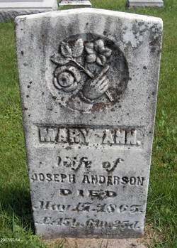
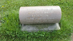
| Birth | : | 1817 Kentucky, USA |
| Death | : | 12 Feb 1882 Maquoketa, Jackson County, Iowa, USA |
| Burial | : | Saint Elizabeth Catholic Cemetery, Makoti, Ward County, USA |
| Coordinate | : | 47.9773600, -101.8074600 |
| Description | : | Aged: 85Y. |
frequently asked questions (FAQ):
-
Where is Joseph A. Anderson's memorial?
Joseph A. Anderson's memorial is located at: Saint Elizabeth Catholic Cemetery, Makoti, Ward County, USA.
-
When did Joseph A. Anderson death?
Joseph A. Anderson death on 12 Feb 1882 in Maquoketa, Jackson County, Iowa, USA
-
Where are the coordinates of the Joseph A. Anderson's memorial?
Latitude: 47.9773600
Longitude: -101.8074600
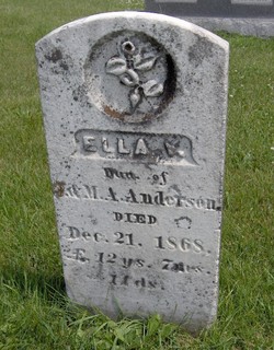
Family Members:
Spouse
Children

Flowers:


Nearby Cemetories:
1. Saint Elizabeth Catholic Cemetery
Makoti, Ward County, USA
Coordinate: 47.9773600, -101.8074600
2. Hope Lutheran Cemetery
Makoti, Ward County, USA
Coordinate: 47.9637070, -101.7867420
3. Saint Pauls Lutheran Cemetery
Makoti, Ward County, USA
Coordinate: 47.9057560, -101.8191380
4. East Community Cemetery
Plaza, Mountrail County, USA
Coordinate: 48.0243988, -101.9383011
5. Rosehill Cemetery
Ryder, Ward County, USA
Coordinate: 47.9266600, -101.6706500
6. First Lutheran Wabek Cemetery
Wabek, Mountrail County, USA
Coordinate: 47.9633300, -101.9691000
7. Sacred Heart Cemetery
Plaza, Mountrail County, USA
Coordinate: 48.0139008, -101.9618988
8. Spring Valley Lutheran Cemetery
Ward County, USA
Coordinate: 48.0813000, -101.8785400
9. First Lutheran Cemetery
Plaza, Mountrail County, USA
Coordinate: 48.0374985, -101.9542007
10. Anna Township Cemetery
Makoti, Ward County, USA
Coordinate: 48.0199410, -101.6152740
11. Hiland Cemetery
Ryder, Ward County, USA
Coordinate: 48.0729103, -101.6588669
12. Hiddenwood Cemetery
McLean County, USA
Coordinate: 47.8330994, -101.7743988
13. Emrich Cemetery
Roseglen, McLean County, USA
Coordinate: 47.7947180, -101.8082670
14. Lucky Mound Lutheran Cemetery
McLean County, USA
Coordinate: 47.8338990, -102.0010640
15. Early Settlers Cemetery
Ward County, USA
Coordinate: 48.0229301, -101.5136490
16. Zion Lutheran Cemetery
South Prairie, Ward County, USA
Coordinate: 48.0524107, -101.5223840
17. Trinity Lutheran Cemetery
Plaza, Mountrail County, USA
Coordinate: 48.1385307, -102.0082397
18. Roseglen Baptist Cemetery
Roseglen, McLean County, USA
Coordinate: 47.7738991, -101.9246979
19. Saint Bridgets Cemetery
Parshall, Mountrail County, USA
Coordinate: 47.9622700, -102.1328910
20. Parshall Cemetery
Parshall, Mountrail County, USA
Coordinate: 47.9357200, -102.1282000
21. Bethlehem Lutheran Cemetery
Roseglen, McLean County, USA
Coordinate: 47.7602882, -101.9143037
22. Holy Cross Cemetery
Douglas, Ward County, USA
Coordinate: 47.8622730, -101.4986600
23. Trinity Lutheran Cemetery
Douglas, Ward County, USA
Coordinate: 47.8626200, -101.4973700
24. Douglas City Cemetery
Douglas, Ward County, USA
Coordinate: 47.8610600, -101.4975100