

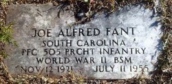


Joseph Alfred “Joe” Fant
| Birth | : | 12 Nov 1921 |
| Death | : | 11 Jul 1955 |
| Burial | : | Rutland Rural Cemetery, Rutland, Worcester County, USA |
| Coordinate | : | 42.3790100, -71.9447500 |
| Plot | : | Southside |
| Inscription | : | South Carolina PFC 505 PRCHT INFANTRY World War II BSM |
frequently asked questions (FAQ):
-
Where is Joseph Alfred “Joe” Fant's memorial?
Joseph Alfred “Joe” Fant's memorial is located at: Rutland Rural Cemetery, Rutland, Worcester County, USA.
-
When did Joseph Alfred “Joe” Fant death?
Joseph Alfred “Joe” Fant death on 11 Jul 1955 in
-
Where are the coordinates of the Joseph Alfred “Joe” Fant's memorial?
Latitude: 42.3790100
Longitude: -71.9447500
Family Members:
Parent

Spouse

Siblings
Children


Nearby Cemetories:
1. Rutland Rural Cemetery
Rutland, Worcester County, USA
Coordinate: 42.3790100, -71.9447500
2. Old Burial Ground
Rutland, Worcester County, USA
Coordinate: 42.3756000, -71.9578000
3. Smith Family Cemetery
Rutland, Worcester County, USA
Coordinate: 42.3946064, -71.9231169
4. Putnam Farm Cemetery
Rutland, Worcester County, USA
Coordinate: 42.3484010, -71.9771420
5. Goose Hill Cemetery
Rutland, Worcester County, USA
Coordinate: 42.3997400, -71.9914000
6. West Rutland Cemetery
Rutland, Worcester County, USA
Coordinate: 42.3561970, -71.9897170
7. Rutland Prison Camp Cemetery
Rutland, Worcester County, USA
Coordinate: 42.3988500, -71.9923800
8. Mooreland Cemetery
Paxton, Worcester County, USA
Coordinate: 42.3280800, -71.9321000
9. South Burying Ground
Princeton, Worcester County, USA
Coordinate: 42.4192009, -71.8957977
10. Worcester County Memorial Park
Paxton, Worcester County, USA
Coordinate: 42.3245697, -71.9308777
11. Saint Mary Cemetery
Holden, Worcester County, USA
Coordinate: 42.3522400, -71.8684200
12. Grove Cemetery
Holden, Worcester County, USA
Coordinate: 42.3520400, -71.8672700
13. Green Hollow Cemetery
Oakham, Worcester County, USA
Coordinate: 42.3549995, -72.0243988
14. Park Avenue Cemetery
Holden, Worcester County, USA
Coordinate: 42.3514200, -71.8656900
15. Old Burying Ground
Holden, Worcester County, USA
Coordinate: 42.3505800, -71.8626000
16. Paxton Center Cemetery
Paxton, Worcester County, USA
Coordinate: 42.3128900, -71.9277700
17. West Cemetery
Princeton, Worcester County, USA
Coordinate: 42.4454100, -71.9256500
18. Saint Francis Episcopal Church Memorial Garden
Holden, Worcester County, USA
Coordinate: 42.3522800, -71.8588700
19. Parker Cemetery
Barre, Worcester County, USA
Coordinate: 42.4250800, -72.0240400
20. Oakham Center Cemetery
Oakham, Worcester County, USA
Coordinate: 42.3540000, -72.0421400
21. Route 62 Cemetery
Hubbardston, Worcester County, USA
Coordinate: 42.4426910, -72.0014980
22. South Cemetery
Oakham, Worcester County, USA
Coordinate: 42.3382988, -72.0374985
23. Woodlawn Cemetery
Princeton, Worcester County, USA
Coordinate: 42.4447260, -71.8835880
24. Coldbrook Cemetery
Barre, Worcester County, USA
Coordinate: 42.3944016, -72.0541992