
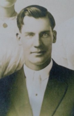
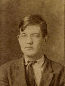
Joseph Christy “Joe” Raper
| Birth | : | 30 Aug 1891 Pawnee City, Pawnee County, Nebraska, USA |
| Death | : | 26 Dec 1961 Pawnee City, Pawnee County, Nebraska, USA |
| Burial | : | Greenlawn Cemetery, Checotah, McIntosh County, USA |
| Coordinate | : | 35.4510994, -95.5391998 |
| Description | : | OBITUARY-THE PAWNEE REPUBLICAN JANUARY 4, 1962 Joe Raper was born in the year 1891 and passed away on Dec. 26, 1961. He was the son of Joseph C. Raper and Eliza Hall Raper, who have preceded him in death. He was married to Mary Lena Lynch on June 30, 1912 . Joe Raper lived his life in this vicinity, and farmed most of the time, until he became a local police officer. Joe was a church member. His survivors are his wife, Mary Raper and a son, Alfred Raper and two grandchildren, Richard L. and Nancy K. Raper, all of San Diego, Calif. Joe... Read More |
frequently asked questions (FAQ):
-
Where is Joseph Christy “Joe” Raper's memorial?
Joseph Christy “Joe” Raper's memorial is located at: Greenlawn Cemetery, Checotah, McIntosh County, USA.
-
When did Joseph Christy “Joe” Raper death?
Joseph Christy “Joe” Raper death on 26 Dec 1961 in Pawnee City, Pawnee County, Nebraska, USA
-
Where are the coordinates of the Joseph Christy “Joe” Raper's memorial?
Latitude: 35.4510994
Longitude: -95.5391998
Family Members:
Parent
Spouse

Siblings
Flowers:


Nearby Cemetories:
1. Greenlawn Cemetery
Checotah, McIntosh County, USA
Coordinate: 35.4510994, -95.5391998
2. Indian Territory Checotah Cemetery
McIntosh County, USA
Coordinate: 35.4687195, -95.5317001
3. Checotah IOOF Home Cemetery
Checotah, McIntosh County, USA
Coordinate: 35.4808200, -95.5152700
4. McNaulty Cemetery
Checotah, McIntosh County, USA
Coordinate: 35.4393997, -95.4863968
5. Paradise Cemetery
Checotah, McIntosh County, USA
Coordinate: 35.4799995, -95.4860992
6. Richard Cemetery
McIntosh County, USA
Coordinate: 35.4397011, -95.6033020
7. Carr Creek Cemetery
Onapa, McIntosh County, USA
Coordinate: 35.3990300, -95.4918500
8. Brush Hill Cemetery
Brush Hill, McIntosh County, USA
Coordinate: 35.4211800, -95.6309500
9. West Cemetery
McIntosh County, USA
Coordinate: 35.4502983, -95.4389038
10. Long Horn Loop Cemetery
Eufaula, McIntosh County, USA
Coordinate: 35.3819470, -95.6080480
11. Honey Springs Battlefield Mass Grave
Rentiesville, McIntosh County, USA
Coordinate: 35.5303140, -95.4860430
12. Calvary Cemetery
Eufaula, McIntosh County, USA
Coordinate: 35.3689800, -95.5855200
13. Cathay Cemetery
McIntosh County, USA
Coordinate: 35.3613400, -95.5680100
14. Vandier Cemetery
McIntosh County, USA
Coordinate: 35.4935989, -95.4310989
15. Combs Cemetery
Rentiesville, McIntosh County, USA
Coordinate: 35.5382800, -95.4816600
16. McNik Cemetery
McIntosh County, USA
Coordinate: 35.4961014, -95.6556015
17. Honey Springs Cemetery
Rentiesville, McIntosh County, USA
Coordinate: 35.5471992, -95.4824982
18. Fishertown Cemetery
Texanna, McIntosh County, USA
Coordinate: 35.3397200, -95.5503500
19. Fame Cemetery
Fame, McIntosh County, USA
Coordinate: 35.3669014, -95.6296997
20. Big Arbor Cemetery (Defunct)
McIntosh County, USA
Coordinate: 35.3842010, -95.6541977
21. Middleton Chapel Cemetery
Wainwright, Muskogee County, USA
Coordinate: 35.5699997, -95.5355988
22. Twin Grove Cemetery
Checotah, McIntosh County, USA
Coordinate: 35.4288500, -95.3903400
23. Meore Cemetery
McIntosh County, USA
Coordinate: 35.3717003, -95.6632996
24. Moore Cemetery
McIntosh County, USA
Coordinate: 35.3715800, -95.6633100