
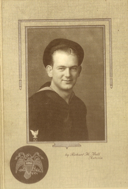
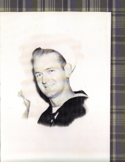
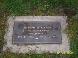
Joseph Ernest “Joe” Raper
| Birth | : | 14 Jul 1922 Milaca, Mille Lacs County, Minnesota, USA |
| Death | : | 10 Nov 1998 Grandview, Jackson County, Missouri, USA |
| Burial | : | Fairburn Cemetery, Fairburn, Custer County, USA |
| Coordinate | : | 43.6871986, -103.1956024 |
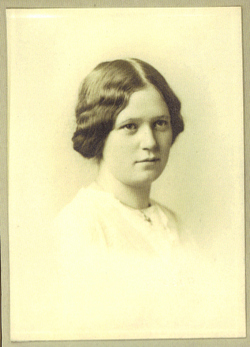
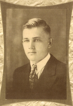
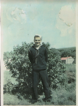
| Description | : | Joe was son of George Lyle & Emma (Faris) Raper, he worked for 35 years as a crane operator and retired from L.G. Barcus & Sons, Kansas City, KS., in 1986. He graduated from high school in Burchard, NE., and served in the U.S. Coast Guard from August 13, 1941 to June 17, 1946. He later attended Peru State College, Peru, NE. He was married for a short time to Mabel (Jynx) Newton, they married March 6, 1942 at Astoria, Oregon. And then to Ruth Houston. There wer no children issue of either marriage. He was preceded in death by his... Read More |
frequently asked questions (FAQ):
-
Where is Joseph Ernest “Joe” Raper's memorial?
Joseph Ernest “Joe” Raper's memorial is located at: Fairburn Cemetery, Fairburn, Custer County, USA.
-
When did Joseph Ernest “Joe” Raper death?
Joseph Ernest “Joe” Raper death on 10 Nov 1998 in Grandview, Jackson County, Missouri, USA
-
Where are the coordinates of the Joseph Ernest “Joe” Raper's memorial?
Latitude: 43.6871986
Longitude: -103.1956024
Family Members:
Parent
Spouse
Siblings

Flowers:


Nearby Cemetories:
1. Fairburn Cemetery
Fairburn, Custer County, USA
Coordinate: 43.6871986, -103.1956024
2. Cornelius Donahue Burial Site
Custer County, USA
Coordinate: 43.6079380, -103.2996950
3. Highland Park Cemetery
Hermosa, Custer County, USA
Coordinate: 43.8386750, -103.2044510
4. Major James Whitehead Burial Site
Custer County, USA
Coordinate: 43.7169500, -103.4535500
5. Unnamed Cemetery
Perkins County, USA
Coordinate: 43.5886700, -102.9506900
6. Boot Hill Cemetery
Buffalo Gap, Custer County, USA
Coordinate: 43.4874600, -103.3205660
7. Buffalo Gap Cemetery
Fall River County, USA
Coordinate: 43.4747009, -103.3131027
8. Hayward Cemetery
Pennington County, USA
Coordinate: 43.8879500, -103.3511800
9. Seventh-day Adventist Cemetery
Red Shirt, Oglala Lakota County, USA
Coordinate: 43.6576800, -102.8796700
10. Cold Springs Cemetery
Custer County, USA
Coordinate: 43.6232700, -103.5075000
11. Christ Church Episcopal Cemetery
Red Shirt, Oglala Lakota County, USA
Coordinate: 43.6228800, -102.8836200
12. Wind Cave National Park Cemetery
Pringle, Custer County, USA
Coordinate: 43.5579400, -103.4793600
13. Harney City Cemetery
Harney, Pennington County, USA
Coordinate: 43.8908000, -103.3887800
14. Keystone Cemetery
Keystone, Pennington County, USA
Coordinate: 43.8835983, -103.4147034
15. W G Flats Cemetery
Oral, Fall River County, USA
Coordinate: 43.4193100, -103.1793000
16. Hines Cemetery
Fall River County, USA
Coordinate: 43.4230995, -103.2722015
17. Folsom Cemetery
Hermosa, Custer County, USA
Coordinate: 43.7905860, -102.8045750
18. Rockerville Cemetery
Rockerville, Pennington County, USA
Coordinate: 43.9681015, -103.3572006
19. Pringle Cemetery
Pringle, Custer County, USA
Coordinate: 43.6086006, -103.6042023
20. Custer Cemetery
Custer, Custer County, USA
Coordinate: 43.7781181, -103.6159592
21. Hot Springs National Cemetery
Hot Springs, Fall River County, USA
Coordinate: 43.4394684, -103.4722214
22. Evergreen Cemetery
Hot Springs, Fall River County, USA
Coordinate: 43.4458008, -103.4843979
23. Fairview Cemetery
Oral, Fall River County, USA
Coordinate: 43.3746986, -103.3230972
24. McGillycuddy Monument
Pennington County, USA
Coordinate: 43.8865110, -103.5670850