
| Birth | : | 25 Jul 1885 Clay County, Kansas, USA |
| Death | : | 4 Aug 1976 Goessel, Marion County, Kansas, USA |
| Burial | : | Evergreen Cemetery, Red Oak, Montgomery County, USA |
| Coordinate | : | 41.0228004, -95.2205963 |
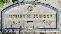
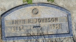
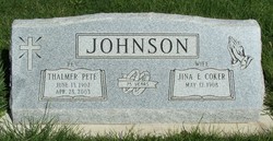
| Description | : | Joe Johnson,91,died at the Goessel Hospital at Goessel,Kansas,Wednesday,August 4th,1976. He was born July 25,1885 in Clay County,Kansas,the son of Richard and Anna Johnson. He was in a Nursing home in Canton for a number of years. He was united in marriage to Ina E. Peterson December 25,1906 and lived in Clay and Washington Counties for the past 67 years. Joe was a farmer until his retirement. He was a member of the Clifton Christian Church for many years. Preceding him in death were his wife,Ina,his mother and father,two brothers,three sisters and four grandchildren. Survivirs are his six children, Elna (Mrs. Francis Gieber),Firth,NE; Melvin Johnson and... Read More |
frequently asked questions (FAQ):
-
Where is Joseph Thomas Johnson's memorial?
Joseph Thomas Johnson's memorial is located at: Evergreen Cemetery, Red Oak, Montgomery County, USA.
-
When did Joseph Thomas Johnson death?
Joseph Thomas Johnson death on 4 Aug 1976 in Goessel, Marion County, Kansas, USA
-
Where are the coordinates of the Joseph Thomas Johnson's memorial?
Latitude: 41.0228004
Longitude: -95.2205963
Family Members:
Parent
Spouse

Siblings
Children
Flowers:


Nearby Cemetories:
1. Evergreen Cemetery
Red Oak, Montgomery County, USA
Coordinate: 41.0228004, -95.2205963
2. Saint Marys Cemetery
Red Oak, Montgomery County, USA
Coordinate: 41.0447006, -95.2275009
3. Shank Cemetery
Red Oak, Montgomery County, USA
Coordinate: 41.0019500, -95.1918300
4. Saint Clair Cemetery
Red Oak Township, Montgomery County, USA
Coordinate: 41.0598400, -95.2049810
5. Hewitt Cemetery
Red Oak, Montgomery County, USA
Coordinate: 40.9850006, -95.2335968
6. Frankfort Cemetery
Montgomery County, USA
Coordinate: 41.0271988, -95.1327972
7. Haefflick Burial Site
Red Oak, Montgomery County, USA
Coordinate: 41.0726300, -95.1561700
8. L Laire Property Cemetery (Defunct)
Sherman Township, Montgomery County, USA
Coordinate: 41.0958257, -95.2224927
9. Indian Graveyard
Sherman Township, Montgomery County, USA
Coordinate: 41.0955730, -95.1837580
10. Salem Cemetery
Red Oak, Montgomery County, USA
Coordinate: 40.9733009, -95.3088989
11. Mamrelund Cemetery
Stanton, Montgomery County, USA
Coordinate: 40.9810486, -95.0959320
12. Mamre Cemetery
Stanton, Montgomery County, USA
Coordinate: 40.9865480, -95.0886400
13. Gomer Cemetery
Wales, Montgomery County, USA
Coordinate: 41.1171989, -95.3082962
14. Lowens Cemetery
Garfield Township, Montgomery County, USA
Coordinate: 41.0527728, -95.3758292
15. Mission Cemetery
Montgomery County, USA
Coordinate: 41.0052986, -95.0603027
16. Tabor Cemetery
Wallin, Montgomery County, USA
Coordinate: 41.0543700, -95.0619900
17. Pilot Grove Presbyterian Cemetery
Wallin, Montgomery County, USA
Coordinate: 41.0793991, -95.0699997
18. Hillside Cemetery
Elliott, Montgomery County, USA
Coordinate: 41.1408005, -95.1544037
19. Center Ridge Cemetery
Montgomery County, USA
Coordinate: 41.1452141, -95.2787018
20. Plum Thicket Cemetery
Nyman, Page County, USA
Coordinate: 40.8916600, -95.2058208
21. Pilot Grove Center Cemetery
Elliott, Montgomery County, USA
Coordinate: 41.1190600, -95.0993700
22. Walnut Cemetery
Montgomery County, USA
Coordinate: 40.9519005, -95.3741989
23. Emerson Cemetery
Emerson, Mills County, USA
Coordinate: 41.0325012, -95.4021988
24. Mount Hope Cemetery
Nyman, Page County, USA
Coordinate: 40.8788986, -95.2046967