
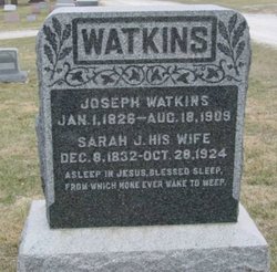
Joseph Watkins
| Birth | : | 1 Jan 1826 Guernsey County, Ohio, USA |
| Death | : | 18 Aug 1909 Osceola, Clarke County, Iowa, USA |
| Burial | : | Hite Cemetery, Biggers, Randolph County, USA |
| Coordinate | : | 36.2985990, -90.8198230 |
| Description | : | The Osceola Sentinel, Thursday, August 19, 1909 After an illness of but a few days from paralysis, Joseph Watkins, one of the noble pioneers of this county passed away at his home in Osceola Wednesday morning, August 18, aged 82 years, 7 months and 17 days. Funeral services will be held at the ME church at 2:30 today (Thursday), Rev. Davis officiating. Mr. Watkins was born in Guernsey Co., Ohio January 1, 1826. He was married January 1, 1851 to Sarah Jane Dutton in Tuscarawas County, Ohio, and soon after came to... Read More |
frequently asked questions (FAQ):
-
Where is Joseph Watkins's memorial?
Joseph Watkins's memorial is located at: Hite Cemetery, Biggers, Randolph County, USA.
-
When did Joseph Watkins death?
Joseph Watkins death on 18 Aug 1909 in Osceola, Clarke County, Iowa, USA
-
Where are the coordinates of the Joseph Watkins's memorial?
Latitude: 36.2985990
Longitude: -90.8198230
Family Members:
Spouse

Children

Flowers:


Nearby Cemetories:
1. Hite Cemetery
Biggers, Randolph County, USA
Coordinate: 36.2985990, -90.8198230
2. Dunn Cemetery #2
Biggers, Randolph County, USA
Coordinate: 36.2916900, -90.8316900
3. Shaver Cemetery
Randolph County, USA
Coordinate: 36.3034800, -90.8404100
4. Johnson-McIlroy Cemetery
Randolph County, USA
Coordinate: 36.2972400, -90.8421800
5. Luttrell Cemetery
Biggers, Randolph County, USA
Coordinate: 36.3120100, -90.8014300
6. Sparkman Cemetery
Biggers, Randolph County, USA
Coordinate: 36.3048500, -90.8441700
7. Yellow Hall Cemetery
Biggers, Randolph County, USA
Coordinate: 36.3258018, -90.8283005
8. Lawnbird Cemetery
Biggers, Randolph County, USA
Coordinate: 36.3177986, -90.7932968
9. Brimmage Cemetery
Randolph County, USA
Coordinate: 36.2801100, -90.8485500
10. Scott Cemetery
Biggers, Randolph County, USA
Coordinate: 36.3300018, -90.8139038
11. Osborn Cemetery
Biggers, Randolph County, USA
Coordinate: 36.3320800, -90.7875000
12. Cherry Cemetery
Randolph County, USA
Coordinate: 36.3222008, -90.7592010
13. Old Reyno Cemetery
Randolph County, USA
Coordinate: 36.3314018, -90.7592010
14. Blount Cemetery
Reyno, Randolph County, USA
Coordinate: 36.3518982, -90.7718964
15. Albrite Cemetery
Greene County, USA
Coordinate: 36.2630997, -90.7482986
16. Johnston Cemetery
Reyno, Randolph County, USA
Coordinate: 36.3568993, -90.7716980
17. Serge Cemetery (Defunct)
Randolph County, USA
Coordinate: 36.2303009, -90.8432999
18. Liberty Cemetery
Randolph County, USA
Coordinate: 36.2207985, -90.8542023
19. Sharum Cemetery
Pocahontas, Randolph County, USA
Coordinate: 36.2207985, -90.8544006
20. Saint John Cemetery
Engelberg, Randolph County, USA
Coordinate: 36.3396988, -90.9092026
21. Brooks Burial Plot
Sharum, Randolph County, USA
Coordinate: 36.2225300, -90.8618400
22. Nelson Clay Cemetery
Clay County, USA
Coordinate: 36.3576800, -90.7396700
23. Davis Cemetery
Engelberg, Randolph County, USA
Coordinate: 36.3513985, -90.9085999
24. Brownie Chapel Cemetery
Peach Orchard, Clay County, USA
Coordinate: 36.2706200, -90.7085200