
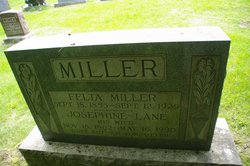
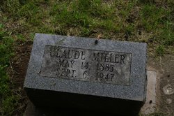
Josephine Lane Miller
| Birth | : | 18 Nov 1862 |
| Death | : | 16 May 1930 |
| Burial | : | Stambaugh Cemetery, Iron River, Iron County, USA |
| Coordinate | : | 46.0774994, -88.6286011 |
| Plot | : | Section 4, Row 26 |
| Description | : | MRS. MARY MILLER FUNERAL RITES HELD Funeral Services Held At Green Mound On Monday Afternoon The church at Green Mound was filled at two o’clock on Monday afternoon, with friends and neighbors, who gathered for the funeral of Mrs. Mary J. Miller, which was held at the time. She was well and widely known among a large circle of acquaintances and they came together to show respect to her memory and sympathy for her children, and others to whom she was united by ties of blood and kinship. Pastor Frank Weston of the First Baptist church, Mt. Pleasant, conducted the service, and preached the... Read More |
frequently asked questions (FAQ):
-
Where is Josephine Lane Miller's memorial?
Josephine Lane Miller's memorial is located at: Stambaugh Cemetery, Iron River, Iron County, USA.
-
When did Josephine Lane Miller death?
Josephine Lane Miller death on 16 May 1930 in
-
Where are the coordinates of the Josephine Lane Miller's memorial?
Latitude: 46.0774994
Longitude: -88.6286011
Family Members:
Parent

Spouse

Siblings
Children
Flowers:


Nearby Cemetories:
1. Stambaugh Cemetery
Iron River, Iron County, USA
Coordinate: 46.0774994, -88.6286011
2. Iron River Cemetery
Iron River, Iron County, USA
Coordinate: 46.1027985, -88.6358032
3. Stambaugh Cemetery
Stambaugh, Iron County, USA
Coordinate: 46.0492670, -88.6409150
4. Resthaven Cemetery
Iron River, Iron County, USA
Coordinate: 46.0964012, -88.6772003
5. Bates Township Cemetery
Mapleton, Iron County, USA
Coordinate: 46.1201629, -88.5664721
6. Indian Cemetery
Crystal Falls, Iron County, USA
Coordinate: 46.0389230, -88.5104410
7. Rosehill Cemetery
Beechwood, Iron County, USA
Coordinate: 46.1568985, -88.7617035
8. Martin Cemetery
Tipler, Florence County, USA
Coordinate: 45.9502983, -88.6549988
9. Tipler Cemetery
Tipler, Florence County, USA
Coordinate: 45.9252100, -88.6334000
10. Lakeview Cemetery
Alvin, Forest County, USA
Coordinate: 45.9831009, -88.8341980
11. Hematite Cemetery
Amasa, Iron County, USA
Coordinate: 46.2356520, -88.4636600
12. Evergreen Memorial Cemetery
Crystal Falls, Iron County, USA
Coordinate: 46.1005620, -88.3124540
13. Long Lake Cemetery
Long Lake, Florence County, USA
Coordinate: 45.8532982, -88.6575012
14. Mansfield Mine Memorial
Mansfield, Iron County, USA
Coordinate: 46.1134700, -88.2178200
15. Commonwealth Cemetery
Commonwealth, Florence County, USA
Coordinate: 45.9144000, -88.2494000
16. Phelps Cemetery
Phelps, Vilas County, USA
Coordinate: 46.0646000, -89.0795000
17. Woodlawn Cemetery
Florence, Florence County, USA
Coordinate: 45.9235992, -88.2343979
18. Volkmann Cemetery
Phelps, Vilas County, USA
Coordinate: 46.0544900, -89.0928900
19. Katakikon Indian Village Cemetery
Watersmeet, Gogebic County, USA
Coordinate: 46.1513889, -89.0850000
20. Forest Home Cemetery
Newald, Forest County, USA
Coordinate: 45.7520800, -88.6962000
21. Schuett Burial Site
Fence, Florence County, USA
Coordinate: 45.7655000, -88.4400100
22. Rosehill East Cemetery
Mansfield, Iron County, USA
Coordinate: 46.0735589, -88.1243176
23. Hillside Cemetery
Fence, Florence County, USA
Coordinate: 45.7366982, -88.4246979
24. Channing Cemetery
Channing, Dickinson County, USA
Coordinate: 46.1302986, -88.0839005