
| Birth | : | 16 Sep 1844 Logansport, Cass County, Indiana, USA |
| Death | : | 17 Oct 1931 Rifle, Garfield County, Colorado, USA |
| Burial | : | Rose Hill Cemetery, Rifle, Garfield County, USA |
| Coordinate | : | 39.5381012, -107.7742004 |
| Plot | : | D-025-05-03 |
| Inscription | : | JOSEPH BINGAMAN 1844-1931 |
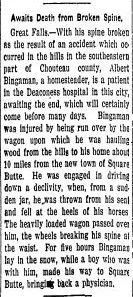
| Description | : | Husband of: (1) Mary Elizabeth RICE; married 11 Dec 1870 in Franklin County, Kansas (2) Mrs. Frances (SATTERLEE) WARNER; married in Aug/Sep 1917, probably in Grand Junction, Mesa County, Colorado. Marriage license was dated 08 Aug 1917. Father of Cornelius Henry, Edward Fredrick, Franklin Livingston, Rice William, Oliver Morton, Elizabeth E., John Albert, & George E. BINGAMAN--all by his 1st wife, Mary. OCCUPATIONAL HISTORY: Farmer Soldier Stonemason Inventor (farm implements) MILITARY SERVICE: Civil War Co. F, 116th Indiana Volunteer Infantry (1863-1864) Co. B, 142nd Indiana Volunteer Infantry (1864-1865) MILITARY SERVICE: Indian Wars--Washita Campaign... Read More |
frequently asked questions (FAQ):
-
Where is Josephus “Joe” Bingaman's memorial?
Josephus “Joe” Bingaman's memorial is located at: Rose Hill Cemetery, Rifle, Garfield County, USA.
-
When did Josephus “Joe” Bingaman death?
Josephus “Joe” Bingaman death on 17 Oct 1931 in Rifle, Garfield County, Colorado, USA
-
Where are the coordinates of the Josephus “Joe” Bingaman's memorial?
Latitude: 39.5381012
Longitude: -107.7742004
Family Members:
Parent
Spouse
Siblings
Children

Flowers:


Nearby Cemetories:
1. Rose Hill Cemetery
Rifle, Garfield County, USA
Coordinate: 39.5381012, -107.7742004
2. Skyline Cemetery
Silt, Garfield County, USA
Coordinate: 39.5520060, -107.6575300
3. Rulison Cemetery
Rulison, Garfield County, USA
Coordinate: 39.4768000, -107.9357000
4. Union Divide Creek Cemetery
Silt, Garfield County, USA
Coordinate: 39.4508018, -107.6200027
5. Highland Cemetery
New Castle, Garfield County, USA
Coordinate: 39.5875015, -107.5192032
6. Battlement Cemetery
Parachute, Garfield County, USA
Coordinate: 39.4380989, -108.0291977
7. Russey-Hurlburt Cemetery
Parachute, Garfield County, USA
Coordinate: 39.4522018, -108.0575027
8. Blackman Ranch Cemetery
Collbran, Mesa County, USA
Coordinate: 39.2647420, -107.8554350
9. Clover Cemetery
Collbran, Mesa County, USA
Coordinate: 39.2550011, -107.9227982
10. Cedar Crest Cemetery
Collbran, Mesa County, USA
Coordinate: 39.2369003, -107.9589005
11. Farnum Holt Columbarium
Glenwood Springs, Garfield County, USA
Coordinate: 39.5469640, -107.3299900
12. Pioneer Cemetery
Glenwood Springs, Garfield County, USA
Coordinate: 39.5392000, -107.3192000
13. Rosebud Cemetery
Glenwood Springs, Garfield County, USA
Coordinate: 39.5168991, -107.3189011
14. Eagalite Cemetery
Plateau City, Mesa County, USA
Coordinate: 39.2228012, -107.9894028
15. DeBeque Cemetery
Mesa County, USA
Coordinate: 39.3374060, -108.2138900
16. Marion Cemetery
Garfield County, USA
Coordinate: 39.3689003, -107.3047028
17. Molina Cemetery
Molina, Mesa County, USA
Coordinate: 39.1886000, -108.0629000
18. Evergreen Cemetery
Carbondale, Garfield County, USA
Coordinate: 39.4077988, -107.2155991
19. Fisher Cemetery
Carbondale, Garfield County, USA
Coordinate: 39.4791985, -107.1911011
20. Mesa Cemetery
Mesa, Mesa County, USA
Coordinate: 39.1685982, -108.1188965
21. Hillcrest Cemetery
Carbondale, Garfield County, USA
Coordinate: 39.3922005, -107.1936035
22. Highland Cemetery
Meeker, Rio Blanco County, USA
Coordinate: 40.0311012, -107.9111023
23. Camp on White River Cemetery
Meeker, Rio Blanco County, USA
Coordinate: 40.0380100, -107.9131000
24. Black Sulphur Cemetery
Meeker, Rio Blanco County, USA
Coordinate: 39.8600800, -108.3109500