
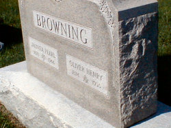
Juanita Pearl “Pearl” Sewell Browning
| Birth | : | 10 Feb 1878 Wichita, Sedgwick County, Kansas, USA |
| Death | : | 30 Aug 1944 Centerville, Linn County, Kansas, USA |
| Burial | : | Oakwood Cemetery, Centerville, Linn County, USA |
| Coordinate | : | 38.1605988, -95.0391998 |
| Description | : | Juanita Pearl Sewell (nickname was Pearl) married Ernest Theodore "Tete" Lowe on November 17, 1902 in St. Joseph, MO. They had no children. Teet died in 1909, after which she married Oliver Henry Browning on November 11, 1911 in Wichita, KS. (Information supplied by another contributor) Thank You |
frequently asked questions (FAQ):
-
Where is Juanita Pearl “Pearl” Sewell Browning's memorial?
Juanita Pearl “Pearl” Sewell Browning's memorial is located at: Oakwood Cemetery, Centerville, Linn County, USA.
-
When did Juanita Pearl “Pearl” Sewell Browning death?
Juanita Pearl “Pearl” Sewell Browning death on 30 Aug 1944 in Centerville, Linn County, Kansas, USA
-
Where are the coordinates of the Juanita Pearl “Pearl” Sewell Browning's memorial?
Latitude: 38.1605988
Longitude: -95.0391998
Family Members:
Spouse
Flowers:


Nearby Cemetories:
1. Oakwood Cemetery
Centerville, Linn County, USA
Coordinate: 38.1605988, -95.0391998
2. Sugar Valley Cemetery
Anderson County, USA
Coordinate: 38.1903300, -95.1130200
3. Centerville Cemetery
Centerville, Linn County, USA
Coordinate: 38.2191000, -94.9969000
4. Pleasant View Cemetery
Blue Mound, Linn County, USA
Coordinate: 38.0952988, -95.0175018
5. Sunny Slope Cemetery
Blue Mound, Linn County, USA
Coordinate: 38.0952988, -95.0149994
6. African Cemetery
Mound City, Linn County, USA
Coordinate: 38.1388600, -94.9361000
7. Old Blue Mound Cemetery
Blue Mound, Linn County, USA
Coordinate: 38.0636600, -95.0249000
8. Sharp-Morrison Cemetery
Centerville, Linn County, USA
Coordinate: 38.2403460, -94.9599410
9. Saint Mary's Mission Cemetery
Mound City, Linn County, USA
Coordinate: 38.2404400, -94.9545500
10. Showalter Cemetery
Centerville, Linn County, USA
Coordinate: 38.2513900, -94.9719600
11. Wesley Chapel Cemetery
Mound City, Linn County, USA
Coordinate: 38.1897800, -94.9072100
12. Kincaid Cemetery
Kincaid, Anderson County, USA
Coordinate: 38.0917015, -95.1513977
13. South Sugar Valley Cemetery
Garnett, Anderson County, USA
Coordinate: 38.2697890, -95.1021450
14. Dingus-Wayne Cemetery
Linn County, USA
Coordinate: 38.1344500, -94.8892500
15. Goodrich Cemetery
Goodrich, Linn County, USA
Coordinate: 38.2771988, -94.9831009
16. Mount Zion Cemetery
Kincaid, Anderson County, USA
Coordinate: 38.1046982, -95.1864014
17. Ackerman Gravesite
Centerville, Linn County, USA
Coordinate: 38.2660510, -94.9431210
18. Boulware Cemetery
Mapleton, Bourbon County, USA
Coordinate: 38.0264600, -95.0245400
19. Osage Valley Cemetery
Mildred, Allen County, USA
Coordinate: 38.0313988, -95.0969009
20. Morris Family Cemetery
Garnett, Anderson County, USA
Coordinate: 38.2434600, -95.1842400
21. Colbert Cemetery
Mound City, Linn County, USA
Coordinate: 38.1094017, -94.8696976
22. Fairbanks Cemetery
Mound City, Linn County, USA
Coordinate: 38.1967010, -94.8606033
23. Park Cemetery
Mound City, Linn County, USA
Coordinate: 38.1383018, -94.8569031
24. Stevenson Cemetery
Mapleton, Bourbon County, USA
Coordinate: 38.0210991, -94.9847031