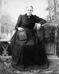
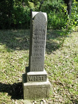
Julia Ann DeFore White
| Birth | : | 14 Jul 1822 |
| Death | : | 9 Feb 1907 |
| Burial | : | White Cemetery, Boone County, USA |
| Coordinate | : | 42.1777992, -93.9636002 |
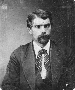
| Description | : | Daughter of James A. and Charlotte Temple (Denny) DeFore. She bore 12 children. Mrs. Julia White, oldest daughter of James and Charlotte Defore, was born in Kentucky July 14, 1822, and died at her home in Dodge Township, Boone County, Iowa, February 9, 1907, age 84 years, six months and 25 days. When she was three years old, she with her parents moved to Indiana, where she was united in marriage to Mathias White, March 7, 1839, and was a devoted wife and faithful mother. In 1847 they moved to Dodge Township not far from Mineral Ridge, and since... Read More |
frequently asked questions (FAQ):
-
Where is Julia Ann DeFore White's memorial?
Julia Ann DeFore White's memorial is located at: White Cemetery, Boone County, USA.
-
When did Julia Ann DeFore White death?
Julia Ann DeFore White death on 9 Feb 1907 in
-
Where are the coordinates of the Julia Ann DeFore White's memorial?
Latitude: 42.1777992
Longitude: -93.9636002
Family Members:
Parent
Spouse
Siblings
Children
Flowers:
Nearby Cemetories:
1. White Cemetery
Boone County, USA
Coordinate: 42.1777992, -93.9636002
2. Mineral Ridge Cemetery
Ridgeport, Boone County, USA
Coordinate: 42.1749992, -93.9266968
3. Runyan Cemetery
Pilot Mound, Boone County, USA
Coordinate: 42.1749992, -94.0015030
4. Schlicht Cemetery
Fraser, Boone County, USA
Coordinate: 42.1444200, -93.9780100
5. Linn Cemetery
Pilot Mound, Boone County, USA
Coordinate: 42.2045330, -93.9970230
6. Boone County Poor Farm Cemetery
Boone County, USA
Coordinate: 42.1591100, -93.9159000
7. Pilot Mound Cemetery
Pilot Mound, Boone County, USA
Coordinate: 42.1636200, -94.0282600
8. Hardin Township Cemetery
Hardin Township, Webster County, USA
Coordinate: 42.2411003, -93.9708023
9. Hickory Grove Cemetery
Boone County, USA
Coordinate: 42.1074982, -93.9507980
10. Buckley Cemetery
Boone, Boone County, USA
Coordinate: 42.0999810, -93.9418960
11. South Marion Cemetery
Stratford, Hamilton County, USA
Coordinate: 42.2327995, -93.8735962
12. Lawn Cemetery
Boone County, USA
Coordinate: 42.1771011, -94.0867996
13. Bass Point Cemetery
Boone, Boone County, USA
Coordinate: 42.0992012, -93.8957977
14. Union Cemetery
Boxholm, Boone County, USA
Coordinate: 42.1369019, -94.0852966
15. Leininger Cemetery
Boone County, USA
Coordinate: 42.1492004, -93.8356018
16. Bluff Creek Cemetery
Boone, Boone County, USA
Coordinate: 42.0774994, -93.9796982
17. Swedish Lutheran Church Cemetery
Dayton, Webster County, USA
Coordinate: 42.2175000, -94.1065000
18. Maas Cemetery
Boone County, USA
Coordinate: 42.0908012, -94.0618973
19. Christ the King Catholic Cemetery
Dayton, Webster County, USA
Coordinate: 42.2601929, -94.0727539
20. Saint Paul Lutheran Cemetery
Boone, Boone County, USA
Coordinate: 42.1700000, -93.8070000
21. Hooks Point Cemetery
Hamilton County, USA
Coordinate: 42.2944530, -93.9199090
22. Oakwood Cemetery
Stratford, Hamilton County, USA
Coordinate: 42.2942009, -93.9182968
23. Dayton Cemetery
Dayton, Webster County, USA
Coordinate: 42.2675000, -94.0755000
24. Bass Cemetery
Dayton, Webster County, USA
Coordinate: 42.2966995, -94.0149994


