


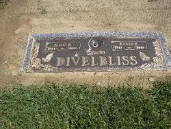
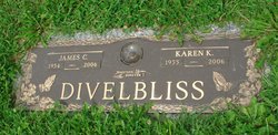
Karen K. Smith Divelbliss
| Birth | : | 16 Mar 1955 USA |
| Death | : | 12 Mar 2006 Dumontville, Fairfield County, Ohio, USA |
| Burial | : | Rose Hill Cemetery, Rifle, Garfield County, USA |
| Coordinate | : | 39.5381012, -107.7742004 |
| Description | : | Karen K. Divelbliss, 50, of Lancaster, Ohio, died at her residence. She was a former employee for Drew Shoe Co. for 18 years and was owner and operator of D&D Sales. She was a member of St. Peters Lutheran Church and Fraternal Order Eagles Lodge Aries 2120. She is survived by her son, Jeremy A. Moore of Lancaster; mother and stepfather, Frances E. And Gordon Hammond of Lancaster; two sisters, Linda (Ray) Schmelzer of Lancaster and Sheila (Brian McCoy) Smith of Roseville, Ohio; two brothers, Edgar Smith Jr. And Doug Hammond, both of Columbus, Ohio; stepdaughters, Kay Morris and Brenda Divelbliss; stepsons,... Read More |
frequently asked questions (FAQ):
-
Where is Karen K. Smith Divelbliss's memorial?
Karen K. Smith Divelbliss's memorial is located at: Rose Hill Cemetery, Rifle, Garfield County, USA.
-
When did Karen K. Smith Divelbliss death?
Karen K. Smith Divelbliss death on 12 Mar 2006 in Dumontville, Fairfield County, Ohio, USA
-
Where are the coordinates of the Karen K. Smith Divelbliss's memorial?
Latitude: 39.5381012
Longitude: -107.7742004
Family Members:
Parent

Spouse

Children

Flowers:


Nearby Cemetories:
1. Rose Hill Cemetery
Rifle, Garfield County, USA
Coordinate: 39.5381012, -107.7742004
2. Skyline Cemetery
Silt, Garfield County, USA
Coordinate: 39.5520060, -107.6575300
3. Rulison Cemetery
Rulison, Garfield County, USA
Coordinate: 39.4768000, -107.9357000
4. Union Divide Creek Cemetery
Silt, Garfield County, USA
Coordinate: 39.4508018, -107.6200027
5. Highland Cemetery
New Castle, Garfield County, USA
Coordinate: 39.5875015, -107.5192032
6. Battlement Cemetery
Parachute, Garfield County, USA
Coordinate: 39.4380989, -108.0291977
7. Russey-Hurlburt Cemetery
Parachute, Garfield County, USA
Coordinate: 39.4522018, -108.0575027
8. Blackman Ranch Cemetery
Collbran, Mesa County, USA
Coordinate: 39.2647420, -107.8554350
9. Clover Cemetery
Collbran, Mesa County, USA
Coordinate: 39.2550011, -107.9227982
10. Cedar Crest Cemetery
Collbran, Mesa County, USA
Coordinate: 39.2369003, -107.9589005
11. Farnum Holt Columbarium
Glenwood Springs, Garfield County, USA
Coordinate: 39.5469640, -107.3299900
12. Pioneer Cemetery
Glenwood Springs, Garfield County, USA
Coordinate: 39.5392000, -107.3192000
13. Rosebud Cemetery
Glenwood Springs, Garfield County, USA
Coordinate: 39.5168991, -107.3189011
14. Eagalite Cemetery
Plateau City, Mesa County, USA
Coordinate: 39.2228012, -107.9894028
15. DeBeque Cemetery
Mesa County, USA
Coordinate: 39.3374060, -108.2138900
16. Marion Cemetery
Garfield County, USA
Coordinate: 39.3689003, -107.3047028
17. Molina Cemetery
Molina, Mesa County, USA
Coordinate: 39.1886000, -108.0629000
18. Evergreen Cemetery
Carbondale, Garfield County, USA
Coordinate: 39.4077988, -107.2155991
19. Fisher Cemetery
Carbondale, Garfield County, USA
Coordinate: 39.4791985, -107.1911011
20. Mesa Cemetery
Mesa, Mesa County, USA
Coordinate: 39.1685982, -108.1188965
21. Hillcrest Cemetery
Carbondale, Garfield County, USA
Coordinate: 39.3922005, -107.1936035
22. Highland Cemetery
Meeker, Rio Blanco County, USA
Coordinate: 40.0311012, -107.9111023
23. Camp on White River Cemetery
Meeker, Rio Blanco County, USA
Coordinate: 40.0380100, -107.9131000
24. Black Sulphur Cemetery
Meeker, Rio Blanco County, USA
Coordinate: 39.8600800, -108.3109500