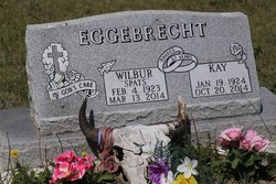
Kathleen “Kay” Steffen Eggebrecht
| Birth | : | 19 Jan 1924 |
| Death | : | 20 Oct 2014 Billings, Yellowstone County, Montana, USA |
| Burial | : | Vida Cemetery, McCone County, USA |
| Coordinate | : | 47.8333015, -105.4685974 |
| Description | : | On Oct. 20, 2014, Kathleen “Kay” Eggebrecht joined the love of her life, Wilbur, in heaven after being apart for only seven months. Kathleen was born to Fred and Molly Steffen on Jan. 19, 1924. She was raised in Bloomfield, on her family homestead. She graduated from Dawson High School in 1942 and went on to Washington during WWII to work at McCord Field in 1944. After longing for home she returned to Montana and met the love of her life, a young cowboy named Wilbur. They were married in 1946 and started their lives in Vida ranching. Together they raised... Read More |
frequently asked questions (FAQ):
-
Where is Kathleen “Kay” Steffen Eggebrecht's memorial?
Kathleen “Kay” Steffen Eggebrecht's memorial is located at: Vida Cemetery, McCone County, USA.
-
When did Kathleen “Kay” Steffen Eggebrecht death?
Kathleen “Kay” Steffen Eggebrecht death on 20 Oct 2014 in Billings, Yellowstone County, Montana, USA
-
Where are the coordinates of the Kathleen “Kay” Steffen Eggebrecht's memorial?
Latitude: 47.8333015
Longitude: -105.4685974
Family Members:
Flowers:
Nearby Cemetories:
1. Vida Cemetery
McCone County, USA
Coordinate: 47.8333015, -105.4685974
2. Holy Eucharist Cemetery
McCone County, USA
Coordinate: 47.7902985, -105.5994034
3. Prairie Lawn Cemetery
Dawson County, USA
Coordinate: 47.7611008, -105.3422012
4. Cow Creek Cemetery
McCone County, USA
Coordinate: 47.7181015, -105.5117035
5. Sacred Heart Catholic Cemetery
Vida, McCone County, USA
Coordinate: 47.8976000, -105.2840000
6. Riverside Cemetery
McCone County, USA
Coordinate: 47.8972015, -105.2835999
7. Immanuel Lutheran Cemetery
McCone County, USA
Coordinate: 47.6835000, -105.4920000
8. Ervine Cemetery
McCone County, USA
Coordinate: 47.7574997, -105.7577972
9. Nickwall Cemetery
Nickwall, McCone County, USA
Coordinate: 48.0497017, -105.3007965
10. Prairie Elk Cemetery
Wolf Point, Roosevelt County, USA
Coordinate: 47.9040851, -105.8199363
11. Grandview Cemetery
Richland County, USA
Coordinate: 47.9556007, -105.1343994
12. Courchene Cemetery
Wolf Point, Roosevelt County, USA
Coordinate: 48.0993996, -105.5927963
13. Prairie Elk Colony Cemetery
McCone County, USA
Coordinate: 48.0159000, -105.7970000
14. Chicken Hill Cemetery
Roosevelt County, USA
Coordinate: 48.0685997, -105.7193985
15. King Memorial Cemetery
Wolf Point, Roosevelt County, USA
Coordinate: 48.0950012, -105.6524963
16. Greenwood Cemetery
Wolf Point, Roosevelt County, USA
Coordinate: 48.1035995, -105.6500015
17. Chelsea Cemetery
Chelsea, Roosevelt County, USA
Coordinate: 48.1385000, -105.3462000
18. Poplar Cemetery
Poplar, Roosevelt County, USA
Coordinate: 48.1124992, -105.1893997
19. Saint Anns Cemetery
Poplar, Roosevelt County, USA
Coordinate: 48.1385994, -105.2589035
20. Oswego Catholic Cemetery
Oswego, Valley County, USA
Coordinate: 48.0480230, -105.8586070
21. Richey Cemetery
Richey, Dawson County, USA
Coordinate: 47.6542015, -105.0417023
22. Box Elder Cemetery
Poplar, Roosevelt County, USA
Coordinate: 48.1417000, -105.2603000
23. Oswego Presbyterian Cemetery
Oswego, Valley County, USA
Coordinate: 48.0428140, -105.8675410
24. Arnett Cemetery
Dawson County, USA
Coordinate: 47.4542007, -105.3638992


