
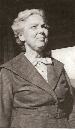

Kathlyn Virginia “Kittie” Miller Wade
| Birth | : | 12 Mar 1894 Hudson Lake, La Porte County, Indiana, USA |
| Death | : | 19 Dec 1980 Wabash, Wabash County, Indiana, USA |
| Burial | : | Flat Cemetery, West Bethel, Oxford County, USA |
| Coordinate | : | 44.3731003, -70.8497009 |
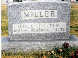
| Description | : | No children. OBITUARY KATHLYN WADE NEW CARLISLE, Ind.-- Mrs. Kathlyn V. Wade, 86, of Converse, Ind., and formerly of New Carlisle, died Friday, Dec. 19, at 9:40 a.m. at Wabash County Hospital, Wabash, Ind., following an illness of six weeks. She was born March 12, 1894, in La Porte County to John Z. and Grace E. (Walker) Miller, and had lived in Converse five years, going there from New Carlisle. She was a member of the United Methodist Church; Sigma Chapter of Delta Beta Phi; taught in New Carlisle schools for 13 years and retired as head librarian of New Carlisle and Olive... Read More |
frequently asked questions (FAQ):
-
Where is Kathlyn Virginia “Kittie” Miller Wade's memorial?
Kathlyn Virginia “Kittie” Miller Wade's memorial is located at: Flat Cemetery, West Bethel, Oxford County, USA.
-
When did Kathlyn Virginia “Kittie” Miller Wade death?
Kathlyn Virginia “Kittie” Miller Wade death on 19 Dec 1980 in Wabash, Wabash County, Indiana, USA
-
Where are the coordinates of the Kathlyn Virginia “Kittie” Miller Wade's memorial?
Latitude: 44.3731003
Longitude: -70.8497009
Family Members:
Parent
Spouse

Siblings
Flowers:


Nearby Cemetories:
1. Flat Cemetery
West Bethel, Oxford County, USA
Coordinate: 44.3731003, -70.8497009
2. Mason Cemetery
Mason Township, Oxford County, USA
Coordinate: 44.3579270, -70.8525530
3. Pine Grove Cemetery
West Bethel, Oxford County, USA
Coordinate: 44.4055600, -70.8563100
4. Scribner Hill Cemetery Upper Yard
Otisfield, Oxford County, USA
Coordinate: 44.3903181, -70.7978794
5. Skillingston Cemetery
Bethel, Oxford County, USA
Coordinate: 44.4085999, -70.8197021
6. Woodland Cemetery
Bethel, Oxford County, USA
Coordinate: 44.3902283, -70.7967911
7. Songo Cemetery
Albany, Oxford County, USA
Coordinate: 44.3464012, -70.7908020
8. Chapman Cemetery
Gilead, Oxford County, USA
Coordinate: 44.4114100, -70.9024900
9. Riverside Cemetery
Bethel, Oxford County, USA
Coordinate: 44.4202995, -70.8058014
10. Peabody Cemetery
Gilead, Oxford County, USA
Coordinate: 44.3987885, -70.9400635
11. Capen Family Cemetery
Bethel, Oxford County, USA
Coordinate: 44.4382283, -70.7925117
12. South Bethel Cemetery
Bethel, Oxford County, USA
Coordinate: 44.4160995, -70.7363968
13. Mount Will Cemetery
North Bethel, Oxford County, USA
Coordinate: 44.4636002, -70.8028030
14. Howe Hill Cemetery
Greenwood, Oxford County, USA
Coordinate: 44.3856010, -70.7142029
15. Hunts Corner Cemetery
Albany, Oxford County, USA
Coordinate: 44.2958333, -70.7606667
16. Middle Intervale Cemetery
Bethel, Oxford County, USA
Coordinate: 44.4638600, -70.7866200
17. Chandler Hill Cemetery
Bethel, Oxford County, USA
Coordinate: 44.4392014, -70.7394028
18. Mount Abram Cemetery
Greenwood, Oxford County, USA
Coordinate: 44.4025002, -70.7078018
19. West Stoneham Cemetery
Stoneham, Oxford County, USA
Coordinate: 44.2665600, -70.8984100
20. Sunday River Cemetery
Newry, Oxford County, USA
Coordinate: 44.4888992, -70.8431015
21. Tallyrand G. Lary Cemetery
Gilead, Oxford County, USA
Coordinate: 44.3960800, -71.0117670
22. Bird Hill Cemetery
Bethel, Oxford County, USA
Coordinate: 44.4234140, -70.6961680
23. Hicks Cemetery
Greenwood, Oxford County, USA
Coordinate: 44.3451390, -70.6823830
24. Black Family Cemetery
Newry, Oxford County, USA
Coordinate: 44.4889670, -70.7895730