

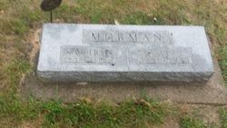
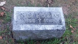
Kathryn B. “Kate” Trecker Morman
| Birth | : | 21 Nov 1890 |
| Death | : | 3 Jul 1977 Coon Rapids, Carroll County, Iowa, USA |
| Burial | : | Coon Rapids Cemetery, Coon Rapids, Carroll County, USA |
| Coordinate | : | 41.8778000, -94.6678009 |
| Inscription | : | Gold Star Mother |
| Description | : | Coon Rapids Enterprise July 7, 1977 Kate Morman, Coon Rapids resident since 1928, died at Thomas Rest Haven on Sunday, July 3, 1977. Mrs. Morman, who was 86 years old, was buried from Annunciation Church; Coon Rapids, Wednesday, July 6. The Mass of the Resurrection was celebrated by Rev. Fr. Edward F. Carpenter at 10:30 a.m. and interment was in Annunciation Cemetery. Casket bearers were her grandsons. The Rosary was recited at the Ohde Funeral Home, Coon Rapids, at 8:00 p.m. Tuesday. She is survived by the following children; Clarence Morman, Carroll, Fred Morman, Manan, No. Dak., Leo... Read More |
frequently asked questions (FAQ):
-
Where is Kathryn B. “Kate” Trecker Morman's memorial?
Kathryn B. “Kate” Trecker Morman's memorial is located at: Coon Rapids Cemetery, Coon Rapids, Carroll County, USA.
-
When did Kathryn B. “Kate” Trecker Morman death?
Kathryn B. “Kate” Trecker Morman death on 3 Jul 1977 in Coon Rapids, Carroll County, Iowa, USA
-
Where are the coordinates of the Kathryn B. “Kate” Trecker Morman's memorial?
Latitude: 41.8778000
Longitude: -94.6678009
Family Members:
Parent
Spouse
Siblings

Children

Flowers:


Nearby Cemetories:
1. Union Township Cemetery
Coon Rapids, Carroll County, USA
Coordinate: 41.8781013, -94.6389008
2. Oak Hill Cemetery
Coon Rapids, Carroll County, USA
Coordinate: 41.9053001, -94.7200012
3. Orange Township Cemetery
Guthrie County, USA
Coordinate: 41.8163986, -94.6844025
4. Old Carrollton Cemetery
Carrollton, Carroll County, USA
Coordinate: 41.9233017, -94.7403030
5. Willow Cemetery
Greene County, USA
Coordinate: 41.9067001, -94.5730972
6. Tuttles Grove Cemetery
Guthrie County, USA
Coordinate: 41.8130989, -94.7228012
7. Highland Cemetery
Bayard, Guthrie County, USA
Coordinate: 41.8241997, -94.5717010
8. McCurdy Cemetery
Carroll County, USA
Coordinate: 41.9403000, -94.7649994
9. Viola Center Cemetery
Viola Center, Audubon County, USA
Coordinate: 41.8236008, -94.8016968
10. Saint Josephs Cemetery
Dedham, Carroll County, USA
Coordinate: 41.8993988, -94.8210983
11. Dedham Cemetery
Dedham, Carroll County, USA
Coordinate: 41.8993988, -94.8225021
12. Union Township Cemetery
Guthrie County, USA
Coordinate: 41.7391450, -94.6858030
13. Seeley Township Cemetery
Guthrie County, USA
Coordinate: 41.7318993, -94.6147003
14. Saint Marys Catholic Cemetery
Willey, Carroll County, USA
Coordinate: 41.9783363, -94.8212204
15. Dodge Center Cemetery
Bagley, Guthrie County, USA
Coordinate: 41.8194008, -94.4697037
16. Scranton Township Cemetery
Scranton, Greene County, USA
Coordinate: 42.0306015, -94.5783005
17. Melville Township Cemetery
Audubon County, USA
Coordinate: 41.7439003, -94.8013992
18. Elba Cemetery
Templeton, Carroll County, USA
Coordinate: 41.9068985, -94.9131012
19. Greenbrier Cemetery
Cooper, Greene County, USA
Coordinate: 41.9063988, -94.4218979
20. Luccocks Grove Cemetery
Audubon County, USA
Coordinate: 41.7619019, -94.8653030
21. Cameron Cemetery
Audubon County, USA
Coordinate: 41.8236008, -94.9167023
22. Moffit Grove Cemetery
Yale, Guthrie County, USA
Coordinate: 41.7668991, -94.4539032
23. West Lawn Cemetery
Glidden, Carroll County, USA
Coordinate: 42.0649986, -94.7406006
24. Dillavou Cemetery
Kendrick Township, Greene County, USA
Coordinate: 42.0802994, -94.6138992