Kristine Mogensdatter Hansen
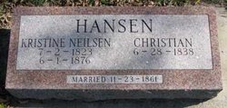
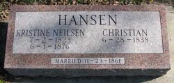
| Birth | : | 3 Jul 1823 Denmark |
| Death | : | 1 Jun 1876 Clay County, South Dakota, USA |
| Burial | : | Rockfield Cemetery, Clay County, USA |
| Coordinate | : | 42.9397011, -96.8302994 |
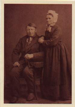
| Description | : | Born in Denmark, Svendborg County, Humble Parish. First married Niels Larsen in 1845. There were 7 children born to this union. Niels Larsen died in 1859 and Kristine then married Christen Hansen in 1861. This family emigrated to Clay County, South Dakota in the years 1869 and 1870. To the second marriage were born 2 children. |
frequently asked questions (FAQ):
-
Where is Kristine Mogensdatter Hansen's memorial?
Kristine Mogensdatter Hansen's memorial is located at: Rockfield Cemetery, Clay County, USA.
-
When did Kristine Mogensdatter Hansen death?
Kristine Mogensdatter Hansen death on 1 Jun 1876 in Clay County, South Dakota, USA
-
Where are the coordinates of the Kristine Mogensdatter Hansen's memorial?
Latitude: 42.9397011
Longitude: -96.8302994
Family Members:
Spouse
Children
Flowers:
Nearby Cemetories:
1. Rockfield Cemetery
Clay County, USA
Coordinate: 42.9397011, -96.8302994
2. Roseni Lutheran Church Cemetery
Beresford, Union County, USA
Coordinate: 42.9388000, -96.7639000
3. Dalesburg Baptist Cemetery
Dalesburg, Clay County, USA
Coordinate: 42.9675102, -96.8850403
4. Olbue Lerseth Cemetery
Beresford, Union County, USA
Coordinate: 42.9281100, -96.7516100
5. Dalesburg Lutheran Cemetery
Vermillion, Clay County, USA
Coordinate: 42.9389424, -96.9242594
6. Clay Point Cemetery
Prairie Center Township, Clay County, USA
Coordinate: 42.8987700, -96.9065600
7. Danefield Seventh Day Advent Cemetery
Clay County, USA
Coordinate: 43.0108000, -96.8452300
8. Saint Joseph Catholic Church Cemetery
Emmet, Union County, USA
Coordinate: 42.9836950, -96.7466350
9. Saint Peter Greenfield Cemetery
Vermillion, Clay County, USA
Coordinate: 42.8608017, -96.8644028
10. Nora Cemetery
Union County, USA
Coordinate: 42.9314003, -96.7061005
11. Saint Mary Cemetery
Union County, USA
Coordinate: 42.8520584, -96.7877502
12. Spirit Mound Cemetery
Clay County, USA
Coordinate: 42.8885994, -96.9424973
13. Pleasant Hill Cemetery Old
Spink, Union County, USA
Coordinate: 42.8588462, -96.7215592
14. Komstad Cemetery
Dalesburg, Clay County, USA
Coordinate: 43.0417938, -96.9058914
15. Saint Peters Cemetery
Clay County, USA
Coordinate: 43.0619011, -96.8244019
16. Old Lodi Cemetery
Lodi, Clay County, USA
Coordinate: 42.9757996, -96.9907990
17. Pleasant Hill Cemetery
Spink, Union County, USA
Coordinate: 42.8741000, -96.6876000
18. Brule Creek Cemetery
Spink Township, Union County, USA
Coordinate: 42.8346510, -96.7324350
19. Ahlsborg Lutheran Cemetery
Union County, USA
Coordinate: 42.8228000, -96.7612000
20. Mortvedt Cemetery
Clay County, USA
Coordinate: 42.9169006, -97.0028000
21. CJ Anderson Homestead
Riverside Township, Clay County, USA
Coordinate: 43.0214180, -96.9675540
22. Pleasant Valley Cemetery
Westerville, Clay County, USA
Coordinate: 42.9247017, -97.0124969
23. Hovde Cemetery
Clay County, USA
Coordinate: 43.0685997, -96.8835983
24. Peace Lutheran Cemetery
Union County, USA
Coordinate: 42.9805984, -96.6481018

