
| Birth | : | 2 Dec 1868 Sumner, Chariton County, Missouri, USA |
| Death | : | 2 Jan 1947 Twisp, Okanogan County, Washington, USA |
| Burial | : | Broughton Cemetery, Clay Center, Clay County, USA |
| Coordinate | : | 39.3306007, -97.0535965 |
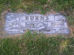
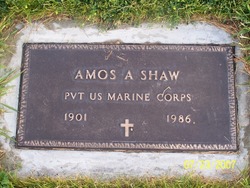
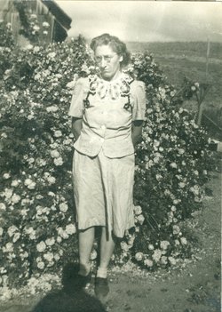
| Description | : | Laura E. Shaw, of Twisp, died at the home of her daughter, Stella Acord, on Jan 2, 1947. Born December 1, 1868 in Sumner, Missouri, she came west in 1889 and married Samuel H. Shaw in Dayton, Washington in 1890, and in 1895 they moved to Pateros. Surviving are three sons: George I Shaw of Twisp, William E. Shaw of Pateros, and Amos A. Shaw of Coulee Dam; five daughters: Mabel Burns of Carlton, Amanda Acord of Pateros, Henrietta Moore of Oroville, California, Stella Acord of Twisp, and Laura Best of Pateros; two brothers: Harve Conger and John Conger of... Read More |
frequently asked questions (FAQ):
-
Where is Laura Eliza Conger Shaw's memorial?
Laura Eliza Conger Shaw's memorial is located at: Broughton Cemetery, Clay Center, Clay County, USA.
-
When did Laura Eliza Conger Shaw death?
Laura Eliza Conger Shaw death on 2 Jan 1947 in Twisp, Okanogan County, Washington, USA
-
Where are the coordinates of the Laura Eliza Conger Shaw's memorial?
Latitude: 39.3306007
Longitude: -97.0535965
Family Members:
Parent
Spouse
Siblings
Children


Flowers:


Nearby Cemetories:
1. Broughton Cemetery
Clay Center, Clay County, USA
Coordinate: 39.3306007, -97.0535965
2. Milo Chapman Gravesite
Broughton, Clay County, USA
Coordinate: 39.2888500, -97.0724400
3. Gilbert Cemetery
Clay County, USA
Coordinate: 39.2853012, -97.0625000
4. Clay County Poor Farm Cemetery
Clay Center, Clay County, USA
Coordinate: 39.3772700, -97.0727000
5. Gatesville Cemetery
Wakefield, Clay County, USA
Coordinate: 39.2721460, -97.0041380
6. Ebenezer Cemetery
Green, Clay County, USA
Coordinate: 39.3866997, -96.9974976
7. Republican City Cemetery
Clay Center, Clay County, USA
Coordinate: 39.3431015, -97.1628036
8. Zion Lutheran Cemetery
Clay County, USA
Coordinate: 39.2928009, -97.1557999
9. Saint Peter and Saint Pauls Catholic Cemetery
Clay Center, Clay County, USA
Coordinate: 39.4005450, -97.1236680
10. Greenwood Cemetery
Clay Center, Clay County, USA
Coordinate: 39.4011002, -97.1275024
11. Bala Cemetery
Bala, Riley County, USA
Coordinate: 39.3053017, -96.9341965
12. Uniondale Cemetery
Wakefield, Clay County, USA
Coordinate: 39.2382800, -97.0918400
13. Green Cemetery
Green, Clay County, USA
Coordinate: 39.4235992, -96.9882965
14. Saint John's Episcopal Cemetery
Clay County, USA
Coordinate: 39.2193985, -97.0744019
15. Pleasant Ridge Cemetery
Clay County, USA
Coordinate: 39.2789001, -97.1841965
16. Highland Cemetery
Wakefield, Clay County, USA
Coordinate: 39.2190247, -97.0133667
17. Wilson Cemetery
Clay County, USA
Coordinate: 39.3800011, -97.1896973
18. Lasita Cemetery
Leonardville, Riley County, USA
Coordinate: 39.4092900, -96.9422900
19. Hayes Cemetery
Clay County, USA
Coordinate: 39.4516983, -97.0811005
20. Timber Creek Cemetery
Wakefield, Clay County, USA
Coordinate: 39.2182999, -96.9805984
21. Mizpah Cemetery
Clay County, USA
Coordinate: 39.2057800, -97.1238500
22. Pleasant Hill Cemetery
Leonardville, Riley County, USA
Coordinate: 39.4371210, -96.9426730
23. Fancy Creek Cemetery
Green, Clay County, USA
Coordinate: 39.4668999, -96.9969025
24. Madura Cemetery
Wakefield, Clay County, USA
Coordinate: 39.1842003, -97.0117035