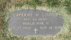
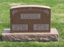
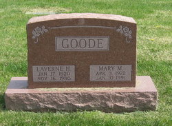
Laverne H. “Jimmie” Goode
| Birth | : | 17 Jan 1920 |
| Death | : | 16 Nov 1980 |
| Burial | : | Canton Hebrew Cemetery, Canton, Stark County, USA |
| Coordinate | : | 40.7722015, -81.3716965 |
| Inscription | : | US ARMY WWII |
| Description | : | Laverne "Jimmie" Goode, 60, Orrick, MO., formerly of Clay county, died Sunday near Orrick. He was born in Clay county and had lived I this area most of his life before moving to Orrick. Mr. Goode was a farmer. he was a member of the Union Baptist Church and the Angeroan Lodge. He was an Army veteran of World War II. He leaves his wife, Mrs. Mary Margaret Goode of the home; eight sons, John Goode, Orrick, James Goode, Excelsior Springs, Paul Goode, Blue Springs, Donald Goode, Missouri City, MO., and Richard Goode, Billy Goode, , Thomas goode and Mark... Read More |
frequently asked questions (FAQ):
-
Where is Laverne H. “Jimmie” Goode's memorial?
Laverne H. “Jimmie” Goode's memorial is located at: Canton Hebrew Cemetery, Canton, Stark County, USA.
-
When did Laverne H. “Jimmie” Goode death?
Laverne H. “Jimmie” Goode death on 16 Nov 1980 in
-
Where are the coordinates of the Laverne H. “Jimmie” Goode's memorial?
Latitude: 40.7722015
Longitude: -81.3716965
Family Members:
Spouse
Flowers:
Nearby Cemetories:
1. Canton Hebrew Cemetery
Canton, Stark County, USA
Coordinate: 40.7722015, -81.3716965
2. Hillcrest Cemetery
Canton, Stark County, USA
Coordinate: 40.7512880, -81.3828120
3. Plum Street Cemetery
Canton, Stark County, USA
Coordinate: 40.7961380, -81.3798090
4. Rowland Cemetery
Canton, Stark County, USA
Coordinate: 40.7930984, -81.3533020
5. West Lawn Cemetery
Canton, Stark County, USA
Coordinate: 40.8046640, -81.3948940
6. Mount Zion Cemetery
Canton, Stark County, USA
Coordinate: 40.7419879, -81.3415546
7. McKinley Memorial Park
Canton, Stark County, USA
Coordinate: 40.8073600, -81.3931910
8. Niesz Cemetery
Canton, Stark County, USA
Coordinate: 40.7515320, -81.4276610
9. Saint Peters Cemetery
Canton, Stark County, USA
Coordinate: 40.8205986, -81.3796997
10. Saint Johns Cemetery
Canton, Stark County, USA
Coordinate: 40.8199997, -81.3846970
11. Valley Chapel Cemetery
Canton, Stark County, USA
Coordinate: 40.8047218, -81.3202744
12. Melscheimer Cemetery
Pike Township, Stark County, USA
Coordinate: 40.7202988, -81.3716965
13. Gerber Cemetery
Canton, Stark County, USA
Coordinate: 40.7369440, -81.4269440
14. Stark County Infirmary Cemetery (Defunct)
Plain Township, Stark County, USA
Coordinate: 40.8283450, -81.3859340
15. Eden Church Of The Brethren Cemetery
Canton, Stark County, USA
Coordinate: 40.7375600, -81.4387300
16. Chestnutwood Cemetery
East Sparta, Stark County, USA
Coordinate: 40.7101600, -81.3722500
17. Union Cemetery
East Canton, Stark County, USA
Coordinate: 40.7839088, -81.2878036
18. Kountze Memorial Cemetery
Canton, Stark County, USA
Coordinate: 40.7847800, -81.2870500
19. Brenizer Cemetery
East Canton, Stark County, USA
Coordinate: 40.7750610, -81.2835760
20. Greenridge Cemetery
Stark County, USA
Coordinate: 40.7118988, -81.3336029
21. Mount Tabor Methodist Church Cemetery
East Canton, Stark County, USA
Coordinate: 40.7848015, -81.2829971
22. Evergreen Memorial Gardens
Louisville, Stark County, USA
Coordinate: 40.8156013, -81.2977982
23. Siffert Cemetery
Stark County, USA
Coordinate: 40.7150002, -81.4297028
24. Sancta Clara Monastery Cemetery
Canton, Stark County, USA
Coordinate: 40.8450430, -81.3642880


