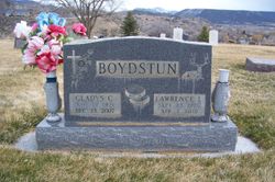
Lawrence Leo Boydstun
| Birth | : | 23 Sep 1920 Prague, Lincoln County, Oklahoma, USA |
| Death | : | 7 Apr 2001 Rifle, Garfield County, Colorado, USA |
| Burial | : | Skyline Cemetery, Silt, Garfield County, USA |
| Coordinate | : | 39.5520060, -107.6575300 |
| Plot | : | E - 48A |
| Inscription | : | Boydstun Lawrence L. Sept. 23, 1920 Apr. 7, 2001 Aug 23 1942 |
| Description | : | An obituary appears in the Glenwood Post on April 14, 2001 P:2 Lawrence L. Boydstun Silt resident, 80 Lawrence Leo Boydstun, 80, of Silt, Colorado died on April 7, 2001 at Clagett Memorial Hospital. He was born Sept 23, 1920 to Howell Boydstun and Lea McClung Boydstun in Prague, Okla. Lawrence graduated from Silt Union High School in 1938. He enlisted in the Air Force in June of 1942 and served until Sept. 5, 1945. He was stationed in England where he flew in 30 combat missions. He received an honorable discharge as a tech sergeant and earned the... Read More |
frequently asked questions (FAQ):
-
Where is Lawrence Leo Boydstun's memorial?
Lawrence Leo Boydstun's memorial is located at: Skyline Cemetery, Silt, Garfield County, USA.
-
When did Lawrence Leo Boydstun death?
Lawrence Leo Boydstun death on 7 Apr 2001 in Rifle, Garfield County, Colorado, USA
-
Where are the coordinates of the Lawrence Leo Boydstun's memorial?
Latitude: 39.5520060
Longitude: -107.6575300
Family Members:
Parent
Spouse
Siblings
Children
Flowers:
Nearby Cemetories:
1. Skyline Cemetery
Silt, Garfield County, USA
Coordinate: 39.5520060, -107.6575300
2. Rose Hill Cemetery
Rifle, Garfield County, USA
Coordinate: 39.5381012, -107.7742004
3. Union Divide Creek Cemetery
Silt, Garfield County, USA
Coordinate: 39.4508018, -107.6200027
4. Highland Cemetery
New Castle, Garfield County, USA
Coordinate: 39.5875015, -107.5192032
5. Rulison Cemetery
Rulison, Garfield County, USA
Coordinate: 39.4768000, -107.9357000
6. Farnum Holt Columbarium
Glenwood Springs, Garfield County, USA
Coordinate: 39.5469640, -107.3299900
7. Pioneer Cemetery
Glenwood Springs, Garfield County, USA
Coordinate: 39.5392000, -107.3192000
8. Rosebud Cemetery
Glenwood Springs, Garfield County, USA
Coordinate: 39.5168991, -107.3189011
9. Battlement Cemetery
Parachute, Garfield County, USA
Coordinate: 39.4380989, -108.0291977
10. Russey-Hurlburt Cemetery
Parachute, Garfield County, USA
Coordinate: 39.4522018, -108.0575027
11. Blackman Ranch Cemetery
Collbran, Mesa County, USA
Coordinate: 39.2647420, -107.8554350
12. Marion Cemetery
Garfield County, USA
Coordinate: 39.3689003, -107.3047028
13. Clover Cemetery
Collbran, Mesa County, USA
Coordinate: 39.2550011, -107.9227982
14. Fisher Cemetery
Carbondale, Garfield County, USA
Coordinate: 39.4791985, -107.1911011
15. Evergreen Cemetery
Carbondale, Garfield County, USA
Coordinate: 39.4077988, -107.2155991
16. Cedar Crest Cemetery
Collbran, Mesa County, USA
Coordinate: 39.2369003, -107.9589005
17. Hillcrest Cemetery
Carbondale, Garfield County, USA
Coordinate: 39.3922005, -107.1936035
18. Eagalite Cemetery
Plateau City, Mesa County, USA
Coordinate: 39.2228012, -107.9894028
19. Dotsero Cemetery
Dotsero, Eagle County, USA
Coordinate: 39.6477600, -107.0672200
20. Molina Cemetery
Molina, Mesa County, USA
Coordinate: 39.1886000, -108.0629000
21. DeBeque Cemetery
Mesa County, USA
Coordinate: 39.3374060, -108.2138900
22. Hillside Cemetery
Redstone, Pitkin County, USA
Coordinate: 39.1843300, -107.2418900
23. Highland Cemetery
Meeker, Rio Blanco County, USA
Coordinate: 40.0311012, -107.9111023
24. Mesa Cemetery
Mesa, Mesa County, USA
Coordinate: 39.1685982, -108.1188965


