
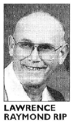
Lawrence Raymond “Laurie” Rip
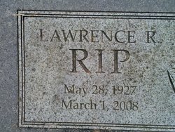
| Birth | : | 28 May 1927 Oak Harbor, Island County, Washington, USA |
| Death | : | 1 Mar 2008 Bellingham, Whatcom County, Washington, USA |
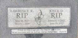
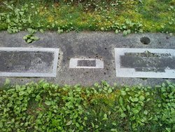
| Burial | : | Saint Paul Lutheran Cemetery, Sulphur Springs, Crawford County, USA |
| Coordinate | : | 40.8950000, -82.8880000 |
| Inscription | : | O God, our help in ages past, Our Hope for years to come, Be our sure Guide while life shall last, and our eternal Home. – Psalm 90 |
| Description | : | Obituary Lawrence Raymond "Laurie" Rip, 80, was called home to be with the Lord, on March 1, 2008, at St. Joseph's Medical Center, Bellingham. He was born May 28, 1927, in Oak Harbor to Peter and Paulina (Roodzant) Rip and was one of four siblings raised on the family farm, on what is now the NAS Whidbey Golf Course. He attended public schools and then the Oak Harbor Christian School from the fifth through the eighth grade, while working on the family farm. Laurie left school after the eighth grade to work on his brother Jake's... Read More |
frequently asked questions (FAQ):
-
Where is Lawrence Raymond “Laurie” Rip's memorial?
Lawrence Raymond “Laurie” Rip's memorial is located at: Saint Paul Lutheran Cemetery, Sulphur Springs, Crawford County, USA.
-
When did Lawrence Raymond “Laurie” Rip death?
Lawrence Raymond “Laurie” Rip death on 1 Mar 2008 in Bellingham, Whatcom County, Washington, USA
-
Where are the coordinates of the Lawrence Raymond “Laurie” Rip's memorial?
Latitude: 40.8950000
Longitude: -82.8880000
Family Members:
Parent

Spouse

Siblings
Flowers:


Nearby Cemetories:
1. Saint Paul Lutheran Cemetery
Sulphur Springs, Crawford County, USA
Coordinate: 40.8950000, -82.8880000
2. Yider Cemetery
Crawford County, USA
Coordinate: 40.8929900, -82.9020070
3. Union Cemetery
Sulphur Springs, Crawford County, USA
Coordinate: 40.8857994, -82.8561020
4. Brenner Cemetery
Chatfield, Crawford County, USA
Coordinate: 40.9203230, -82.9014880
5. Conley Cemetery
Crawford County, USA
Coordinate: 40.8592880, -82.8950910
6. Kruse Cemetery
Sulphur Springs, Crawford County, USA
Coordinate: 40.8561540, -82.8815730
7. Roop Cemetery
Crawford County, USA
Coordinate: 40.8499414, -82.9139471
8. Tustison Cemetery
Dekalb, Crawford County, USA
Coordinate: 40.8787130, -82.8220330
9. Liberty Chapel Cemetery
Crawford County, USA
Coordinate: 40.8422794, -82.8935178
10. Durr Cemetery
Chatfield, Crawford County, USA
Coordinate: 40.9325910, -82.9398440
11. Moffet Cemetery
Crawford County, USA
Coordinate: 40.9070420, -82.9584930
12. Lust Cemetery
Crawford County, USA
Coordinate: 40.9216995, -82.9514008
13. Sandusky Cemetery
Bucyrus, Crawford County, USA
Coordinate: 40.8654728, -82.8175378
14. Old Chatfield Lutheran Cemetery
Chatfield, Crawford County, USA
Coordinate: 40.9391690, -82.9467750
15. Luke Cemetery
Crawford County, USA
Coordinate: 40.8363991, -82.8553009
16. Union Cemetery
New Washington, Crawford County, USA
Coordinate: 40.9538994, -82.8516998
17. Nazareth Lutheran Cemetery
Chatfield, Crawford County, USA
Coordinate: 40.9436676, -82.9460203
18. Blowers Cemetery
Bucyrus, Crawford County, USA
Coordinate: 40.8282040, -82.8964160
19. Smith-Eulis Cemetery
Chatfield, Crawford County, USA
Coordinate: 40.9641990, -82.8921250
20. Swaab Cemetery
New Washington, Crawford County, USA
Coordinate: 40.9653015, -82.8822021
21. Chatfield Township Cemetery
Chatfield, Crawford County, USA
Coordinate: 40.9503343, -82.9462982
22. Loss Creek Cemetery
Galion, Crawford County, USA
Coordinate: 40.8445280, -82.8164860
23. Saint Johns Lutheran Cemetery
New Washington, Crawford County, USA
Coordinate: 40.9648330, -82.8536890
24. Saint Bernard Cemetery
New Washington, Crawford County, USA
Coordinate: 40.9678001, -82.8538971