
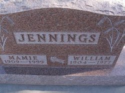
| Birth | : | 28 Jul 1935 Allison, Decatur County, Kansas, USA |
| Death | : | 8 Feb 2011 Jennings, Decatur County, Kansas, USA |
| Burial | : | Shiloh Southern Congregational ME Church Cemetery, Homerville, Clinch County, USA |
| Coordinate | : | 31.0116024, -82.6426392 |
| Description | : | JENNINGS, Kansas -- Lawrence William Jennings, 75, died Tuesday (Feb. 8, 2011), at his residence near Jennings. He was born July 28, 1935, south of Jennings, in the Allison area, to William Lawrence and Mamie Helen (Fiala) Jennings. He attended country schools at Solomon Valley and Custer before entering Oberlin Grade School. He graduated from Decatur County High School in 1953 and then continued his education at Kansas State College in Manhattan, taking agricultural classes. He joined the U.S. Air Force in January 1955 and became an aircraft mechanic, serving at bases in Australia,... Read More |
frequently asked questions (FAQ):
-
Where is Lawrence William Jennings's memorial?
Lawrence William Jennings's memorial is located at: Shiloh Southern Congregational ME Church Cemetery, Homerville, Clinch County, USA.
-
When did Lawrence William Jennings death?
Lawrence William Jennings death on 8 Feb 2011 in Jennings, Decatur County, Kansas, USA
-
Where are the coordinates of the Lawrence William Jennings's memorial?
Latitude: 31.0116024
Longitude: -82.6426392
Family Members:
Parent

Siblings
Flowers:


Nearby Cemetories:
1. Shiloh Southern Congregational ME Church Cemetery
Homerville, Clinch County, USA
Coordinate: 31.0116024, -82.6426392
2. Lawrence Smith
Jamestown, Clinch County, USA
Coordinate: 30.9777560, -82.6078320
3. Griffis Cemetery
Clinch County, USA
Coordinate: 30.9680996, -82.6607971
4. Smith Gravesites
Homerville, Clinch County, USA
Coordinate: 31.0147640, -82.7106140
5. Antioch Methodist Church Cemetery
Homerville, Clinch County, USA
Coordinate: 30.9512090, -82.5912930
6. Miller Cemetery
Jamestown, Clinch County, USA
Coordinate: 30.9359490, -82.5833700
7. Chauncey Cemetery
Homerville, Clinch County, USA
Coordinate: 30.9108009, -82.6699982
8. Hard Scramble Cemetery
Clinch County, USA
Coordinate: 30.9321995, -82.7202988
9. Pine Forest Cemetery
Homerville, Clinch County, USA
Coordinate: 31.0375004, -82.7605972
10. Old J.L. Morgan Farm Cemetery
Homerville, Clinch County, USA
Coordinate: 30.9036980, -82.6562400
11. Ramah Cemetery
Colon, Clinch County, USA
Coordinate: 30.9036007, -82.6557999
12. New Pine Grove Church Cemetery
Homerville, Clinch County, USA
Coordinate: 31.1086200, -82.7080070
13. Eason Cemetery
Clinch County, USA
Coordinate: 30.9500008, -82.7786026
14. Holmes Chapel Cemetery
Clinch County, USA
Coordinate: 31.0767002, -82.8003006
15. Sirmans Rest Cemetery
Homerville, Clinch County, USA
Coordinate: 31.0830800, -82.8243100
16. Hilliard Cemetery
Clinch County, USA
Coordinate: 30.8582993, -82.7382965
17. Thomas Fullwood Gravesite
Midway, Clinch County, USA
Coordinate: 30.8257120, -82.6505760
18. Dame Family Cemetery
Clinch County, USA
Coordinate: 30.9067001, -82.8300018
19. North Cemetery
Du Pont, Clinch County, USA
Coordinate: 31.0167007, -82.8719025
20. Prospect Church Cemetery
Du Pont, Clinch County, USA
Coordinate: 31.0377950, -82.8859880
21. Arabia Cemetery
Homerville, Clinch County, USA
Coordinate: 31.1124992, -82.8863983
22. Langs Church Cemetery
Homerville, Clinch County, USA
Coordinate: 31.1796494, -82.8526459
23. Red Bluff Cemetery
Pearson, Atkinson County, USA
Coordinate: 31.2272960, -82.7846790
24. Jordan Cemetery
Fargo, Clinch County, USA
Coordinate: 30.7962620, -82.4847510