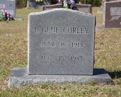
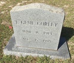
Leander Gene “L.G.” Corley
| Birth | : | 16 Jun 1913 Hornbeck, Vernon Parish, Louisiana, USA |
| Death | : | 15 Aug 1985 Joplin, Jasper County, Missouri, USA |
| Burial | : | Nashville Cemetery, Nashville, Darke County, USA |
| Coordinate | : | 40.0924630, -84.7429060 |
| Description | : | Sabine Index, Many, La., Aug 22, 1985 Mr. L. Gene Corley, 72, of Carthage, Missouri, died in Joplin, Missouri, on Thursday, August 15, 1985, at 8:10 a.m. Mr. Corley was a retired salesman. He also owned and operated clothing stores in Monett and Harrisonville, Missouri. He was a member of the First United Methodist Church of Carthage, Missouri. Rev. Earl Marr officiated the graveside services in Mt. Carmel Cemetery, on Aug. 19, at 2 p.m. Services were under the direction of the Warren Meadows Funeral Home. Survivors include his wife, Mrs. Vallie Corley of Carthage, Mo.; one... Read More |
frequently asked questions (FAQ):
-
Where is Leander Gene “L.G.” Corley's memorial?
Leander Gene “L.G.” Corley's memorial is located at: Nashville Cemetery, Nashville, Darke County, USA.
-
When did Leander Gene “L.G.” Corley death?
Leander Gene “L.G.” Corley death on 15 Aug 1985 in Joplin, Jasper County, Missouri, USA
-
Where are the coordinates of the Leander Gene “L.G.” Corley's memorial?
Latitude: 40.0924630
Longitude: -84.7429060
Family Members:
Parent
Spouse
Siblings
Children
Flowers:
Nearby Cemetories:
1. Nashville Cemetery
Nashville, Darke County, USA
Coordinate: 40.0924630, -84.7429060
2. Sharpeye Cemetery
Washington Township, Darke County, USA
Coordinate: 40.1064360, -84.7441260
3. Dininger Cemetery
Coletown, Darke County, USA
Coordinate: 40.0918999, -84.7069016
4. Hiller Cemetery
Washington Township, Darke County, USA
Coordinate: 40.0995310, -84.7077570
5. Chenoweth Cemetery
Sharpeye, Darke County, USA
Coordinate: 40.1036100, -84.7809700
6. Palestine Cemetery
Palestine, Darke County, USA
Coordinate: 40.0539690, -84.7424930
7. Miller Grove German Baptist Church Cemetery
Palestine, Darke County, USA
Coordinate: 40.0554700, -84.7269280
8. Clemens Cemetery
Long, Darke County, USA
Coordinate: 40.0814056, -84.8006897
9. Emanuel Cemetery
Coletown, Darke County, USA
Coordinate: 40.1293983, -84.7069016
10. Bass Cemetery
Long, Darke County, USA
Coordinate: 40.0638510, -84.7990330
11. West Branch Cemetery
New Madison, Darke County, USA
Coordinate: 40.0503006, -84.7039032
12. Crickbaum Cemetery
Greenville, Darke County, USA
Coordinate: 40.1288850, -84.6937660
13. Griffis Cemetery (Defunct)
South Salem, Randolph County, USA
Coordinate: 40.1113000, -84.8113000
14. Saint John's Cemetery
Palestine, Darke County, USA
Coordinate: 40.0350000, -84.7447000
15. Spring Hill Cemetery
Darke County, USA
Coordinate: 40.1383018, -84.7900009
16. West Zion Cemetery
Palestine, Darke County, USA
Coordinate: 40.0411590, -84.7063460
17. Rush Station Cemetery
Greenville, Darke County, USA
Coordinate: 40.1413890, -84.6966670
18. Alexander Graveyard
Spartanburg, Randolph County, USA
Coordinate: 40.0811310, -84.8207779
19. Kaucher Family Cemetery
Hill Grove, Darke County, USA
Coordinate: 40.1511110, -84.7658330
20. Mount Zion Cemetery
Darke County, USA
Coordinate: 40.0417000, -84.6839000
21. Horn Cemetery
Hollansburg, Darke County, USA
Coordinate: 40.0322970, -84.7984670
22. Snell Cemetery
Hill Grove, Darke County, USA
Coordinate: 40.1685982, -84.7564011
23. Beech Grove Cemetery
Hollansburg, Darke County, USA
Coordinate: 40.0157000, -84.7570700
24. Greenville Union Cemetery
Greenville, Darke County, USA
Coordinate: 40.1082993, -84.6436005

