
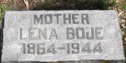
Lena Bunning Boje
| Birth | : | 15 Oct 1864 Schleswig-Holstein, Germany |
| Death | : | 25 Oct 1944 Pierce, Pierce County, Nebraska, USA |
| Burial | : | St Andrews Presbyterian Cemetery, Clevedon, Auckland Council, New Zealand |
| Coordinate | : | -36.9921320, 175.0371370 |
| Plot | : | Block 13 Lot 9 Grave 1534 |
| Description | : | MOTHER |
frequently asked questions (FAQ):
-
Where is Lena Bunning Boje's memorial?
Lena Bunning Boje's memorial is located at: St Andrews Presbyterian Cemetery, Clevedon, Auckland Council, New Zealand.
-
When did Lena Bunning Boje death?
Lena Bunning Boje death on 25 Oct 1944 in Pierce, Pierce County, Nebraska, USA
-
Where are the coordinates of the Lena Bunning Boje's memorial?
Latitude: -36.9921320
Longitude: 175.0371370
Family Members:
Parent
Spouse
Siblings

Children
Flowers:


Nearby Cemetories:
1. St Andrews Presbyterian Cemetery
Clevedon, Auckland Council, New Zealand
Coordinate: -36.9921320, 175.0371370
2. Clevedon Cemetery All Souls Church
Clevedon, Auckland Council, New Zealand
Coordinate: -36.9862400, 175.0418100
3. St James Churchyard Ardmore
Auckland Council, New Zealand
Coordinate: -37.0364180, 174.9992160
4. Waikopua Cemetery
Whitford, Auckland Council, New Zealand
Coordinate: -36.9274400, 174.9998900
5. Alfriston Cemetery
Auckland Council, New Zealand
Coordinate: -37.0133660, 174.9479400
6. Hunua Presbyterian Cemetery
Hunua, Auckland Council, New Zealand
Coordinate: -37.0792290, 175.0742700
7. Papakura Cemetery
Papakura, Auckland Council, New Zealand
Coordinate: -37.0698600, 174.9448300
8. St. Paul's Anglican Cemetery
East Tamaki, Auckland Council, New Zealand
Coordinate: -36.9615200, 174.9082000
9. Flat Bush Cemetery
East Tamaki, Auckland Council, New Zealand
Coordinate: -36.9563500, 174.9097100
10. Howick Cemetery
Howick, Auckland Council, New Zealand
Coordinate: -36.9040400, 174.9380500
11. St. David's Anglican Churchyard
Wiri, Auckland Council, New Zealand
Coordinate: -37.0025400, 174.8886150
12. St. John's Church Cemetery
East Tamaki, Auckland Council, New Zealand
Coordinate: -36.9522250, 174.8964540
13. Papakura South Cemetery
Papakura, Auckland Council, New Zealand
Coordinate: -37.0877300, 174.9464700
14. Woodside Methodist Cemetery
Manukau, Auckland Council, New Zealand
Coordinate: -36.9929680, 174.8837860
15. All Saints Cemetery
Howick, Auckland Council, New Zealand
Coordinate: -36.8954260, 174.9337600
16. Drury Presbyterian Cemetery
Drury, Auckland Council, New Zealand
Coordinate: -37.0991270, 174.9497870
17. Drury-Runciman War Memorial
Drury, Auckland Council, New Zealand
Coordinate: -37.1025480, 174.9528240
18. Our Lady Star of the Sea Parish Cemetery
Howick, Auckland Council, New Zealand
Coordinate: -36.8932940, 174.9307940
19. St John's Anglican Cemetery Drury
Drury, Auckland Council, New Zealand
Coordinate: -37.1033710, 174.9506070
20. St. Andrew Presbyterian Cemetery
Howick, Auckland Council, New Zealand
Coordinate: -36.8989900, 174.9201600
21. Howick Historical Village
Pakuranga, Auckland Council, New Zealand
Coordinate: -36.9067680, 174.9027080
22. Ararimu Cemetery
Ararimu, Auckland Council, New Zealand
Coordinate: -37.1321000, 175.0484200
23. St. John's Presbyterian Church Cemetery
Papatoetoe, Auckland Council, New Zealand
Coordinate: -36.9674185, 174.8598178
24. Pakuranga Methodist Cemetery
Pakuranga, Auckland Council, New Zealand
Coordinate: -36.9054000, 174.8914900