


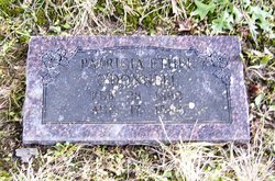
Lena Irene McFadden Eisenhart
| Birth | : | 18 Apr 1917 Neosho, Newton County, Missouri, USA |
| Death | : | 29 Jan 2008 Pittsburg, Crawford County, Kansas, USA |
| Burial | : | Keene Old Presbyterian Church Cemetery, Coshocton County, USA |
| Coordinate | : | 40.3480700, -81.8707900 |
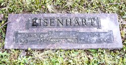
| Description | : | IRENE MCFADDEN-EISENHART Irene Eisenhart, 90, of Pittsburg, Kansas, died at 6:50pm, Tuesday, January 29, 2008 at Mt. Carmel Regional Medical Center in Pittsburg, Kansas. Irene was born April 18, 1917 in Neosho, Missouri to Milton and Patricia Ethel (O'Donnell) McFadden. On October 15, 1940, she married John M. Eisenhart. He preceded her in death on June 18, 1979. Irene worked for PSU in the Alumni Dept and the University Post Office for 25 years, retiring in 1978. Irene was a member of the First United Methodist Church where she was very active. She volunteered for Wesley House, where she served on... Read More |
frequently asked questions (FAQ):
-
Where is Lena Irene McFadden Eisenhart's memorial?
Lena Irene McFadden Eisenhart's memorial is located at: Keene Old Presbyterian Church Cemetery, Coshocton County, USA.
-
When did Lena Irene McFadden Eisenhart death?
Lena Irene McFadden Eisenhart death on 29 Jan 2008 in Pittsburg, Crawford County, Kansas, USA
-
Where are the coordinates of the Lena Irene McFadden Eisenhart's memorial?
Latitude: 40.3480700
Longitude: -81.8707900
Family Members:
Parent
Spouse
Flowers:


Nearby Cemetories:
1. Keene Old Presbyterian Church Cemetery
Coshocton County, USA
Coordinate: 40.3480700, -81.8707900
2. Keene Methodist Cemetery
Keene, Coshocton County, USA
Coordinate: 40.3431800, -81.8662500
3. Bible Cemetery
Keene, Coshocton County, USA
Coordinate: 40.3330380, -81.8990940
4. Coshocton County Memory Gardens
Coshocton, Coshocton County, USA
Coordinate: 40.3234825, -81.8310089
5. Reamer Cemetery
Coshocton County, USA
Coordinate: 40.3194008, -81.8317032
6. Machpelahs Burial Acres
Keene, Coshocton County, USA
Coordinate: 40.3208950, -81.9126210
7. Amity Cemetery
Keene, Coshocton County, USA
Coordinate: 40.3568993, -81.8167038
8. Knob Cemetery
Keene, Coshocton County, USA
Coordinate: 40.3863983, -81.8358002
9. Casebeer Cemetery
Metham, Coshocton County, USA
Coordinate: 40.3629220, -81.9360840
10. Prairie Chapel Church Cemetery
Coshocton, Coshocton County, USA
Coordinate: 40.3049000, -81.9124000
11. Canal Lewisville Cemetery
Canal Lewisville, Coshocton County, USA
Coordinate: 40.3012500, -81.8357100
12. White Eyes Cemetery
Chili, Coshocton County, USA
Coordinate: 40.3499985, -81.7960968
13. Waring Cemetery
Metham, Coshocton County, USA
Coordinate: 40.3505580, -81.9470740
14. Mount Zion Methodist Church Cemetery
Metham, Coshocton County, USA
Coordinate: 40.3559580, -81.9522140
15. Dutch Meeting House Cemetery
Warsaw, Coshocton County, USA
Coordinate: 40.3796207, -81.9459337
16. Roscoe Cemetery
Coshocton, Coshocton County, USA
Coordinate: 40.2821000, -81.8841000
17. Hill Cemetery
Coshocton County, USA
Coordinate: 40.3208008, -81.7878036
18. Burkhardt Cemetery
Coshocton County, USA
Coordinate: 40.3953800, -81.8049400
19. Oak Grove Cemetery
Coshocton County, USA
Coordinate: 40.3032990, -81.8005981
20. Oak Ridge Cemetery
Coshocton, Coshocton County, USA
Coordinate: 40.2780991, -81.8610992
21. Caldersburg Cemetery
Roscoe, Coshocton County, USA
Coordinate: 40.2755390, -81.8798700
22. Unidentified Cemetery #1
Coshocton, Coshocton County, USA
Coordinate: 40.2753080, -81.8803050
23. Clark Township Baptist Church Cemetery
Clark, Coshocton County, USA
Coordinate: 40.4126680, -81.9229260
24. Fox Cemetery
Blissfield, Coshocton County, USA
Coordinate: 40.4035988, -81.9424973