


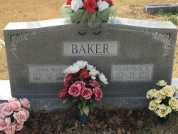
Lena Mae Miller Baker
| Birth | : | 24 Jan 1922 Calm, Oregon County, Missouri, USA |
| Death | : | 7 Dec 2017 Saint Louis, St. Louis City, Missouri, USA |
| Burial | : | Liberty Cemetery, Calm, Oregon County, USA |
| Coordinate | : | 36.5586500, -91.1549600 |
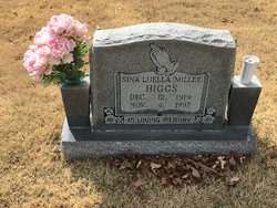
| Description | : | Baker, Lena Mae (nee: Miller) entered into rest on Thursday, December 7, 2017. Beloved wife of the late Clarence Baker. Beloved sister of the late Monroe Miller, Bynum Miller, Houston “Pete” Miller, Bertha Carter, Sina Higgs, Wilma Jackson and Herbert Miller. Our dear daughter, aunt, sister in law, great aunt, great-great aunt and dear friend to many. Special thanks to those who loved and cared for Lena, especially caregivers at Tesson Heights and her special friend Carol Marsh. Visitation at Kutis Affton Chapel, 10151 Gravois on Friday, December 8, 3-7:00 PM with service on Saturday, 1:00... Read More |
frequently asked questions (FAQ):
-
Where is Lena Mae Miller Baker's memorial?
Lena Mae Miller Baker's memorial is located at: Liberty Cemetery, Calm, Oregon County, USA.
-
When did Lena Mae Miller Baker death?
Lena Mae Miller Baker death on 7 Dec 2017 in Saint Louis, St. Louis City, Missouri, USA
-
Where are the coordinates of the Lena Mae Miller Baker's memorial?
Latitude: 36.5586500
Longitude: -91.1549600
Family Members:
Parent

Spouse
Siblings
Flowers:


Nearby Cemetories:
1. Liberty Cemetery
Calm, Oregon County, USA
Coordinate: 36.5586500, -91.1549600
2. Pigman Mound Archeological Site
Calm, Oregon County, USA
Coordinate: 36.5717100, -91.1784800
3. Pleasant Hill Cemetery
Calm, Oregon County, USA
Coordinate: 36.5950012, -91.1425018
4. Spring Valley Cemetery
Billmore, Oregon County, USA
Coordinate: 36.5324670, -91.2003420
5. Mount Carmel Cemetery
Calm, Oregon County, USA
Coordinate: 36.5106010, -91.1643982
6. Old Elmore Thomas field
Billmore, Oregon County, USA
Coordinate: 36.5237770, -91.1980250
7. Gatewood Cemetery
Gatewood, Ripley County, USA
Coordinate: 36.5751600, -91.0900900
8. New Home Cemetery
Tucker (Gatewood), Ripley County, USA
Coordinate: 36.5112100, -91.1089800
9. Tucker Cemetery
Tucker (Gatewood), Ripley County, USA
Coordinate: 36.5426417, -91.0757139
10. O'Neal
Billmore, Oregon County, USA
Coordinate: 36.5712170, -91.2415410
11. Dobbs Lahue Cemetery
Riverton, Oregon County, USA
Coordinate: 36.6269300, -91.1823600
12. Dobbs-LaHue Cemetery
Riverton, Oregon County, USA
Coordinate: 36.6233978, -91.1966476
13. Walnut Grove Cemetery
Elm Store, Randolph County, USA
Coordinate: 36.4914017, -91.1967010
14. Old Jobe Cemetery
Jobe, Oregon County, USA
Coordinate: 36.5917015, -91.2517014
15. Roberts Family Farm Cemetery
Couch, Oregon County, USA
Coordinate: 36.6165300, -91.2401700
16. Cotton Creek Cemetery
Jobe, Oregon County, USA
Coordinate: 36.5844002, -91.2652969
17. Coe Cemetery
Warm Springs, Randolph County, USA
Coordinate: 36.4732400, -91.1102200
18. Riverton Cemetery
Riverton, Oregon County, USA
Coordinate: 36.6476100, -91.2076900
19. Stubblefield Cemetery
Dalton, Randolph County, USA
Coordinate: 36.4597015, -91.1718979
20. Church of God Cemetery
Oregon County, USA
Coordinate: 36.5023500, -91.2580200
21. Myrtle Cemetery
Myrtle, Oregon County, USA
Coordinate: 36.5133900, -91.2664300
22. Boze Mill Cemetery
Boze Mill, Oregon County, USA
Coordinate: 36.6631126, -91.1940231
23. Macedonia Cemetery
Warm Springs, Randolph County, USA
Coordinate: 36.4707985, -91.0742035
24. Reynolds Cemetery
Elm Store, Randolph County, USA
Coordinate: 36.4491997, -91.1860962