
| Birth | : | 7 May 1937 Albuquerque, Bernalillo County, New Mexico, USA |
| Death | : | 6 Nov 2011 Clay Center, Clay County, Kansas, USA |
| Burial | : | Highland Cemetery, Wakefield, Clay County, USA |
| Coordinate | : | 39.2190247, -97.0133667 |
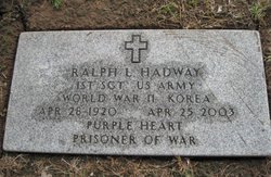
| Description | : | LEON CHARLES COLP CLAY CENTER-- Leon Charles Colp, 74, died Friday, Nov. 6, 2011, at Clay County Medical Center, Clay Center. Mr. Colp was born May 7, 1937 at Albuquerque, N.M., the son of Amel and Mary (Hazen) Colp. He grew up in Clay Center and graduated from CCCHS in 1955. He married [redacted for privacy]. He worked for Sears & Roebuck, Co-op and drove a truck for Girton Propane until his retirement in 2002. He was preceded in death by one brother, Ralph Hadway and one sister, Irene Lenhart. Survivors include his wife [redacted]; four daughters [redacted]; two sons [redacted]; 21 grandchildren; and... Read More |
frequently asked questions (FAQ):
-
Where is Leon Charles Colp's memorial?
Leon Charles Colp's memorial is located at: Highland Cemetery, Wakefield, Clay County, USA.
-
When did Leon Charles Colp death?
Leon Charles Colp death on 6 Nov 2011 in Clay Center, Clay County, Kansas, USA
-
Where are the coordinates of the Leon Charles Colp's memorial?
Latitude: 39.2190247
Longitude: -97.0133667
Family Members:
Parent

Siblings
Flowers:


Nearby Cemetories:
1. Highland Cemetery
Wakefield, Clay County, USA
Coordinate: 39.2190247, -97.0133667
2. Timber Creek Cemetery
Wakefield, Clay County, USA
Coordinate: 39.2182999, -96.9805984
3. Madura Cemetery
Wakefield, Clay County, USA
Coordinate: 39.1842003, -97.0117035
4. Saint John's Episcopal Cemetery
Clay County, USA
Coordinate: 39.2193985, -97.0744019
5. Gatesville Cemetery
Wakefield, Clay County, USA
Coordinate: 39.2721460, -97.0041380
6. Uniondale Cemetery
Wakefield, Clay County, USA
Coordinate: 39.2382800, -97.0918400
7. Gilbert Cemetery
Clay County, USA
Coordinate: 39.2853012, -97.0625000
8. Barry Cemetery
Milford, Geary County, USA
Coordinate: 39.1889000, -96.9218979
9. Milo Chapman Gravesite
Broughton, Clay County, USA
Coordinate: 39.2888500, -97.0724400
10. Mizpah Cemetery
Clay County, USA
Coordinate: 39.2057800, -97.1238500
11. Milford Cemetery
Milford, Geary County, USA
Coordinate: 39.1828003, -96.9047012
12. Bala Cemetery
Bala, Riley County, USA
Coordinate: 39.3053017, -96.9341965
13. Branscom Cemetery
Milford, Geary County, USA
Coordinate: 39.1627998, -96.8942032
14. Broughton Cemetery
Clay Center, Clay County, USA
Coordinate: 39.3306007, -97.0535965
15. Alida Cemetery
Geary County, USA
Coordinate: 39.1030998, -96.9618988
16. Liberty Cemetery
Upland, Dickinson County, USA
Coordinate: 39.0896988, -97.0278015
17. Athelstane Cemetery
Athelstane Township, Clay County, USA
Coordinate: 39.1768990, -97.1753006
18. Zion Lutheran Cemetery
Clay County, USA
Coordinate: 39.2928009, -97.1557999
19. Shanks Cemetery
Riley, Riley County, USA
Coordinate: 39.1750000, -96.8413400
20. Greenridge Cemetery
Dickinson County, USA
Coordinate: 39.1199989, -97.1433029
21. Pleasant Ridge Cemetery
Clay County, USA
Coordinate: 39.2789001, -97.1841965
22. Alida Zion Evangelical Cemetery
Upland, Dickinson County, USA
Coordinate: 39.0750008, -96.9721985
23. Saint Johns Cemetery
Geary County, USA
Coordinate: 39.0741997, -96.9610977
24. Vinton Cemetery
Geary County, USA
Coordinate: 39.1375008, -96.8399963