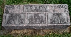
| Birth | : | 16 Nov 1920 Jackson County, Iowa, USA |
| Death | : | 15 Feb 2007 Maquoketa, Jackson County, Iowa, USA |
| Burial | : | St. Helen's Cemetery and Crematorium, St Helens, Metropolitan Borough of St Helens, England |
| Coordinate | : | 53.4678993, -2.7607000 |
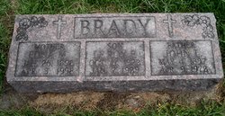
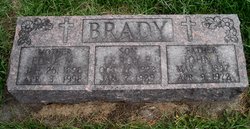
| Description | : | Leonard Vern Brady age 86 of Maquoketa Iowa died on Thursday evening February 15, 2007 at his home in rural Maquoketa Iowa. A celebration of his life will be held at 10:30 A.M. Tuesday February 20, 2007 from the Carson & Son Funeral And Cremation Services in Maquoketa Iowa with Chaplain/Celebrant Rev. Ruth Ann Scott of Carson & Son Funeral And Cremation Services in Maquoketa officiating. Visitation will be held from 4 to 7 P.M. on Monday February 19, 2007 from the Carson & Son Funeral And Cremation Services in Maquoketa Iowa. Burial will be in the Mount Hope Cemetery Maquoketa... Read More |
frequently asked questions (FAQ):
-
Where is Leonard LaVerne “Vern” Brady's memorial?
Leonard LaVerne “Vern” Brady's memorial is located at: St. Helen's Cemetery and Crematorium, St Helens, Metropolitan Borough of St Helens, England.
-
When did Leonard LaVerne “Vern” Brady death?
Leonard LaVerne “Vern” Brady death on 15 Feb 2007 in Maquoketa, Jackson County, Iowa, USA
-
Where are the coordinates of the Leonard LaVerne “Vern” Brady's memorial?
Latitude: 53.4678993
Longitude: -2.7607000
Family Members:
Parent
Spouse
Siblings
Flowers:
Nearby Cemetories:
1. St. Helen's Cemetery and Crematorium
St Helens, Metropolitan Borough of St Helens, England
Coordinate: 53.4678993, -2.7607000
2. Windleshaw Chantry
St Helens, Metropolitan Borough of St Helens, England
Coordinate: 53.4672417, -2.7550773
3. Christ Church Churchyard
Eccleston, Metropolitan Borough of St Helens, England
Coordinate: 53.4542560, -2.7778900
4. Friends Meeting House, Hardshaw, St Helens
St Helens, Metropolitan Borough of St Helens, England
Coordinate: 53.4518340, -2.7320414
5. GreenAcres Cemetery
Rainford, Metropolitan Borough of St Helens, England
Coordinate: 53.4713530, -2.8064280
6. St Mary Roman Catholic Churchyard
Billinge, Metropolitan Borough of St Helens, England
Coordinate: 53.4909850, -2.7180090
7. All Saints Church
Rainford, Metropolitan Borough of St Helens, England
Coordinate: 53.5000210, -2.7870990
8. St Peter's of Parr Churchyard
Parr, Metropolitan Borough of St Helens, England
Coordinate: 53.4543745, -2.7009772
9. St Mark Churchyard
Haydock, Metropolitan Borough of St Helens, England
Coordinate: 53.4658540, -2.6892980
10. St Nicholas Churchyard
St Helens, Metropolitan Borough of St Helens, England
Coordinate: 53.4284660, -2.7213830
11. St. Anne and Blessed Dominic Churchyard
St Helens, Metropolitan Borough of St Helens, England
Coordinate: 53.4330960, -2.7083700
12. St. Mary the Virgin Churchyard
Prescot, Metropolitan Borough of Knowsley, England
Coordinate: 53.4284600, -2.8067000
13. Prescot Cemetery
Prescot, Metropolitan Borough of Knowsley, England
Coordinate: 53.4266620, -2.8081590
14. St Ann’s Graveyard
Rainhill, Metropolitan Borough of St Helens, England
Coordinate: 53.4157487, -2.7638276
15. St. Mary's Churchyard
Knowsley, Metropolitan Borough of Knowsley, England
Coordinate: 53.4561960, -2.8528580
16. St James' Churchyard
Haydock, Metropolitan Borough of St Helens, England
Coordinate: 53.4679080, -2.6596350
17. St Bartholomew's Churchyard
Rainhill, Metropolitan Borough of St Helens, England
Coordinate: 53.4076231, -2.7513287
18. Knowsley Cemetery
Knowsley, Metropolitan Borough of Knowsley, England
Coordinate: 53.4083240, -2.7847870
19. Holy Trinity Churchyard
Ashton-In-Makerfield, Metropolitan Borough of Wigan, England
Coordinate: 53.4989280, -2.6688000
20. St. Nicholas' Churchyard
Whiston, Metropolitan Borough of Knowsley, England
Coordinate: 53.4069736, -2.8028920
21. St James Roman Catholic Churchyard
Orrell, Metropolitan Borough of Wigan, England
Coordinate: 53.5300000, -2.7140000
22. St. Michael Churchyard
Huyton with Roby, Metropolitan Borough of Knowsley, England
Coordinate: 53.4139560, -2.8396720
23. Salem Churchyard
Orrell, Metropolitan Borough of Wigan, England
Coordinate: 53.5331572, -2.7107046
24. St Michael Churchyard Extension
Huyton with Roby, Metropolitan Borough of Knowsley, England
Coordinate: 53.4143310, -2.8418050

