

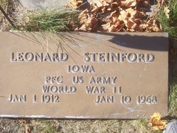
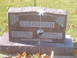
Leonard Steinford
| Birth | : | 1 Jan 1912 Keystone, Benton County, Iowa, USA |
| Death | : | 6 Jan 1968 Keystone, Benton County, Iowa, USA |
| Burial | : | St. Augustine's Parish Churchyard, Locking, North Somerset Unitary Authority, England |
| Coordinate | : | 51.3322900, -2.9147683 |
| Description | : | obit donated by Martha Long |
frequently asked questions (FAQ):
-
Where is Leonard Steinford's memorial?
Leonard Steinford's memorial is located at: St. Augustine's Parish Churchyard, Locking, North Somerset Unitary Authority, England.
-
When did Leonard Steinford death?
Leonard Steinford death on 6 Jan 1968 in Keystone, Benton County, Iowa, USA
-
Where are the coordinates of the Leonard Steinford's memorial?
Latitude: 51.3322900
Longitude: -2.9147683
Family Members:
Parent

Spouse
Siblings


Flowers:


Nearby Cemetories:
1. St. Augustine's Parish Churchyard
Locking, North Somerset Unitary Authority, England
Coordinate: 51.3322900, -2.9147683
2. St Mary the Virgin Churchyard
Hutton, North Somerset Unitary Authority, England
Coordinate: 51.3228030, -2.9306350
3. The Blessed Virgin Mary
Axbridge, Sedgemoor District, England
Coordinate: 51.3112017, -2.8913443
4. St. Martin's Churchyard
Worle, North Somerset Unitary Authority, England
Coordinate: 51.3609960, -2.9301250
5. Banwell War Memorial
Banwell, North Somerset Unitary Authority, England
Coordinate: 51.3278233, -2.8648124
6. Saint Peter and St. Paul Churchyard
Bleadon, North Somerset Unitary Authority, England
Coordinate: 51.3074000, -2.9458300
7. St Mark Churchyard
Weston-super-Mare, North Somerset Unitary Authority, England
Coordinate: 51.3640650, -2.9195540
8. St. Andrew's Churchyard
Banwell, North Somerset Unitary Authority, England
Coordinate: 51.3280700, -2.8637000
9. St Andrew's Church
Loxton, North Somerset Unitary Authority, England
Coordinate: 51.2981560, -2.8962140
10. Ebdon Road Crematorium and Cemetery
Weston-super-Mare, North Somerset Unitary Authority, England
Coordinate: 51.3707090, -2.9254530
11. Weston-Super-Mare Cemetery
Weston-super-Mare, North Somerset Unitary Authority, England
Coordinate: 51.3541300, -2.9676900
12. St Nicholas Churchyard (New)
Uphill, North Somerset Unitary Authority, England
Coordinate: 51.3246210, -2.9778420
13. Weston-super-Mare Emmanuel Churchyard
Weston-super-Mare, North Somerset Unitary Authority, England
Coordinate: 51.3458940, -2.9773860
14. St Paul's Churchyard
Kewstoke, North Somerset Unitary Authority, England
Coordinate: 51.3655390, -2.9566120
15. Saint Pauls Churchyard
Kewstoke, North Somerset Unitary Authority, England
Coordinate: 51.3655500, -2.9568900
16. Old St Nicholas Churchyard
Uphill, North Somerset Unitary Authority, England
Coordinate: 51.3203480, -2.9828110
17. St. John the Baptist Churchyard
Weston-super-Mare, North Somerset Unitary Authority, England
Coordinate: 51.3523010, -2.9813260
18. Saint Andrew Churchyard
Compton Bishop, Sedgemoor District, England
Coordinate: 51.2943290, -2.8678900
19. Winscombe and Sandford Cemetery
Winscombe, North Somerset Unitary Authority, England
Coordinate: 51.3223861, -2.8386889
20. Holy Saviour Churchyard
Puxton, North Somerset Unitary Authority, England
Coordinate: 51.3652680, -2.8536510
21. St. James the Great Churchyard
Winscombe, North Somerset Unitary Authority, England
Coordinate: 51.3059750, -2.8456900
22. St Anne's Church Hewish
Weston-super-Mare, North Somerset Unitary Authority, England
Coordinate: 51.3740520, -2.8666300
23. Wick St. Lawrence Churchyard
Wick St Lawrence, North Somerset Unitary Authority, England
Coordinate: 51.3844000, -2.9117000
24. St Christopher's Churchyard
Lympsham, Sedgemoor District, England
Coordinate: 51.2826740, -2.9546028