
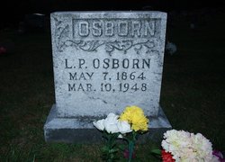

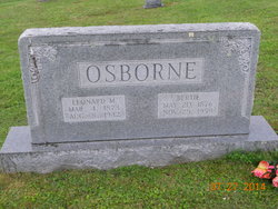
Leonidas Pettigrew “L P” Osborne
| Birth | : | 7 May 1864 North Carolina, USA |
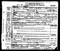
| Death | : | 10 Mar 1948 Ashe County, North Carolina, USA |
| Burial | : | Papatoetoe Cemetery, Papatoetoe, Auckland Council, New Zealand |
| Coordinate | : | -36.9893110, 174.8373530 |
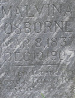
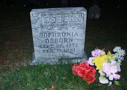
| Description | : | Husband of Saphronia (Boggs) Osborne. |
frequently asked questions (FAQ):
-
Where is Leonidas Pettigrew “L P” Osborne's memorial?
Leonidas Pettigrew “L P” Osborne's memorial is located at: Papatoetoe Cemetery, Papatoetoe, Auckland Council, New Zealand.
-
When did Leonidas Pettigrew “L P” Osborne death?
Leonidas Pettigrew “L P” Osborne death on 10 Mar 1948 in Ashe County, North Carolina, USA
-
Where are the coordinates of the Leonidas Pettigrew “L P” Osborne's memorial?
Latitude: -36.9893110
Longitude: 174.8373530
Family Members:
Parent
Spouse
Siblings

Children
Flowers:


Nearby Cemetories:
1. Papatoetoe Cemetery
Papatoetoe, Auckland Council, New Zealand
Coordinate: -36.9893110, 174.8373530
2. Manukau Memorial Gardens
Manukau, Auckland Council, New Zealand
Coordinate: -36.9944380, 174.8397300
3. St. John's Presbyterian Church Cemetery
Papatoetoe, Auckland Council, New Zealand
Coordinate: -36.9674185, 174.8598178
4. Woodside Methodist Cemetery
Manukau, Auckland Council, New Zealand
Coordinate: -36.9929680, 174.8837860
5. Mangere Presbyterian Cemetery
Mangere, Auckland Council, New Zealand
Coordinate: -36.9750197, 174.7924783
6. Nixon Memorial
Ōtāhūhū, Auckland Council, New Zealand
Coordinate: -36.9499366, 174.8449909
7. St. David's Anglican Churchyard
Wiri, Auckland Council, New Zealand
Coordinate: -37.0025400, 174.8886150
8. St. Joseph and St. Joachim Catholic Cemetery
Ōtāhūhū, Auckland Council, New Zealand
Coordinate: -36.9436100, 174.8490100
9. Mangere Lawn Cemetery
Mangere, Auckland Council, New Zealand
Coordinate: -36.9626150, 174.7857000
10. Otahuhu Public Cemetery
Ōtāhūhū, Auckland Council, New Zealand
Coordinate: -36.9377500, 174.8432390
11. Holy Trinity Memorial Park
Ōtāhūhū, Auckland Council, New Zealand
Coordinate: -36.9374510, 174.8448580
12. Laurie-Gibbons Memorial Park
Weymouth, Auckland Council, New Zealand
Coordinate: -37.0440600, 174.8586790
13. St. John's Church Cemetery
East Tamaki, Auckland Council, New Zealand
Coordinate: -36.9522250, 174.8964540
14. St. Paul's Anglican Cemetery
East Tamaki, Auckland Council, New Zealand
Coordinate: -36.9615200, 174.9082000
15. Mangere Piriti Urupā St. James Churchyard
Mangere, Auckland Council, New Zealand
Coordinate: -36.9418970, 174.7835260
16. Flat Bush Cemetery
East Tamaki, Auckland Council, New Zealand
Coordinate: -36.9563500, 174.9097100
17. Waikaraka Cemetery
Ōnehunga, Auckland Council, New Zealand
Coordinate: -36.9297140, 174.7967170
18. Onehunga Catholic Cemetery
Ōnehunga, Auckland Council, New Zealand
Coordinate: -36.9224360, 174.7884560
19. Our Lady of the Assumption Catholic Church
Ōnehunga, Auckland Council, New Zealand
Coordinate: -36.9223690, 174.7884530
20. St. Peter's Anglican Cemetery
Ōnehunga, Auckland Council, New Zealand
Coordinate: -36.9227113, 174.7847550
21. St Matthias Churchyard
Panmure, Auckland Council, New Zealand
Coordinate: -36.9053300, 174.8577200
22. St. Patrick's Roman Catholic Church Cemetery
Panmure, Auckland Council, New Zealand
Coordinate: -36.9029680, 174.8564960
23. Alfriston Cemetery
Auckland Council, New Zealand
Coordinate: -37.0133660, 174.9479400
24. Hillsborough Cemetery
Hillsborough, Auckland Council, New Zealand
Coordinate: -36.9246600, 174.7524030