
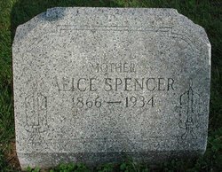
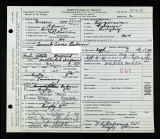
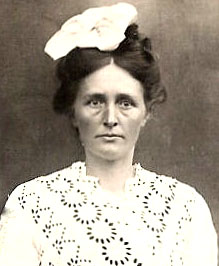
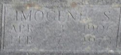
Cynthia Alice Osborne Spencer
| Birth | : | 9 Dec 1865 Grayson County, Virginia, USA |
| Death | : | 19 Dec 1934 Grayson County, Virginia, USA |
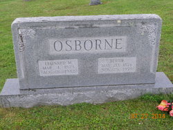
| Burial | : | Haw Orchard Cemetery, Grayson County, USA |
| Coordinate | : | 36.6081009, -81.4950027 |
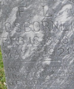
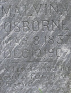
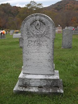
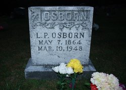
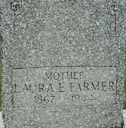
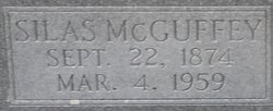
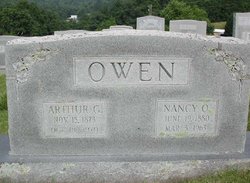
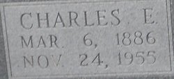
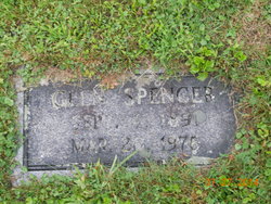
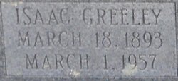
| Description | : | Daughter of Franklin Leander "Lee" Osborne & Malvina Weiss One of fifteen children; 7 sisters & 7 brothers *********************************************** 18?? Shaftner 1858 Emaline (Sturgill) (Reedy) 1860 Wiley 1862 Kirby Missouri 1864 Leonidas Pettigrew 1867 Laura Ellen (Lovelace) (Farmer) 1869 Enoch Cicero 1871 Zachariah B. 1873 Leonard Matthais 1874 Silas McGuffey 1876 Daisy d. 1877 1878 Maude Leona Angeline (Plummer) 1880 Nancy Drucilla (Owen) 1884 Sylvia Married William Troy Spencer 31 Jan 1884 Wilson Creek, Grayson, VA Mother of thirteen children; 6 daughters & 7 sons ************************************ 1885 Florence V. d. 1885 # 95700492 1886 Charles Enoch***see below 1888 Victor Franklin***see below 1891 William Glen***see below 1893 Isaac Greeley***see below 1895 Humphrey Kilby***see below 1897 Blannie Emmaline (Sturgill)***see below 1897 John Blake***see below 1901 Audrey Wave (Spencer)***see below 1904 Malissie***see below 1906 Ollie... Read More |
frequently asked questions (FAQ):
-
Where is Cynthia Alice Osborne Spencer's memorial?
Cynthia Alice Osborne Spencer's memorial is located at: Haw Orchard Cemetery, Grayson County, USA.
-
When did Cynthia Alice Osborne Spencer death?
Cynthia Alice Osborne Spencer death on 19 Dec 1934 in Grayson County, Virginia, USA
-
Where are the coordinates of the Cynthia Alice Osborne Spencer's memorial?
Latitude: 36.6081009
Longitude: -81.4950027
Family Members:
Parent
Spouse
Siblings

Children
Flowers:


Nearby Cemetories:
1. Haw Orchard Cemetery
Grayson County, USA
Coordinate: 36.6081009, -81.4950027
2. Duvall Family Cemetery
Grayson County, USA
Coordinate: 36.5942130, -81.4864020
3. Timothy F Young Cemetery
Rugby, Grayson County, USA
Coordinate: 36.5955220, -81.4797870
4. Richardson Family Cemetery
Rugby, Grayson County, USA
Coordinate: 36.5975760, -81.4766480
5. Fees Ridge Cemetery
Mouth of Wilson, Grayson County, USA
Coordinate: 36.5936130, -81.5113800
6. Osborne Cemetery
Grayson County, USA
Coordinate: 36.6119003, -81.5216980
7. Cabin Creek Cemetery
Grayson County, USA
Coordinate: 36.6116000, -81.5218000
8. Elijah Franklin Sexton Family Cemetery
Mill Creek, Grayson County, USA
Coordinate: 36.6156371, -81.4691845
9. Gideon Weaver Cemetery
Rugby, Grayson County, USA
Coordinate: 36.6156830, -81.4691750
10. Marshel Jones Cemetery
Rugby, Grayson County, USA
Coordinate: 36.6279230, -81.4816490
11. Greer Cemetery
Grayson County, USA
Coordinate: 36.6180992, -81.5243988
12. Phipps Cemetery
Grayson County, USA
Coordinate: 36.5850830, -81.4794240
13. Samuel Tucker Family Cemetery
Mouth of Wilson, Grayson County, USA
Coordinate: 36.6092250, -81.4614260
14. Kilby Cemetery
Grayson County, USA
Coordinate: 36.5825005, -81.5092010
15. Abram Reedy Cemetery
Rugby, Grayson County, USA
Coordinate: 36.5958220, -81.4602810
16. Roby Testerman Family Cemetery
Mouth of Wilson, Grayson County, USA
Coordinate: 36.5818560, -81.4749340
17. Bill Reedy Cemetery
Rugby, Grayson County, USA
Coordinate: 36.5943000, -81.4571000
18. Barnes Cemetery
Rugby, Grayson County, USA
Coordinate: 36.5847700, -81.4625570
19. Ambrose Spencer Family Cemetery
Ashe County, USA
Coordinate: 36.5720300, -81.4873300
20. John Weiss Cemetery
Rugby, Grayson County, USA
Coordinate: 36.5809630, -81.4629810
21. Corinth Baptist Church Cemetery
Rugby, Grayson County, USA
Coordinate: 36.6119240, -81.4470280
22. Lewis-Perry Cemetery
Grayson County, USA
Coordinate: 36.5849991, -81.5355988
23. Quillin Cemetery
Rugby, Grayson County, USA
Coordinate: 36.6006490, -81.4425210
24. Osborne-Williams Cemetery
Low Gap, Grayson County, USA
Coordinate: 36.6266230, -81.4456550