
| Birth | : | 4 Nov 1884 Davis County, Iowa, USA |
| Death | : | 3 Mar 1972 Texas, USA |
| Burial | : | Manleyville Cemetery, Manleyville, Henry County, USA |
| Coordinate | : | 36.2268982, -88.1669006 |
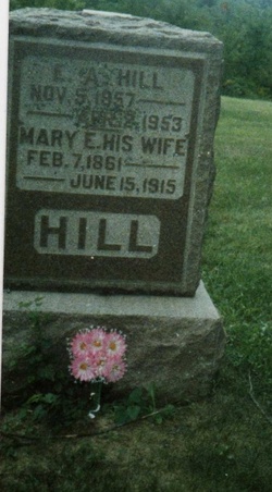
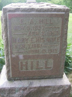
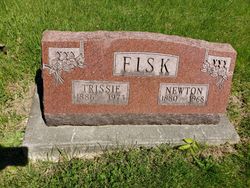
| Description | : | Leslie E. Hill, 87, formerly of Ottumwa, died Thursday in Llano, Texas, where he lived on L.B. Johnson Lake. He was a retired Rock Island Railroad section foreman. He was born November 4, 1884 at Floris, the son of Ellie and Mary Strickland Hill. He had lived in Texas the past five years. He was a member of the Floris Christian Church. He was married to Estella Robbins, January 17, 1918 at Floris. She survivess as does one son, Leslie Hill of Chariton; one daughter, Miss Levenia Hill of Sunrise Beach, Tex.; and two sisters, Mrs. Tressie Fisk of Ottumwa... Read More |
frequently asked questions (FAQ):
-
Where is Leslie E Hill's memorial?
Leslie E Hill's memorial is located at: Manleyville Cemetery, Manleyville, Henry County, USA.
-
When did Leslie E Hill death?
Leslie E Hill death on 3 Mar 1972 in Texas, USA
-
Where are the coordinates of the Leslie E Hill's memorial?
Latitude: 36.2268982
Longitude: -88.1669006
Family Members:
Parent
Spouse

Siblings
Children
Flowers:


Nearby Cemetories:
1. Manleyville Cemetery
Manleyville, Henry County, USA
Coordinate: 36.2268982, -88.1669006
2. Lowry Cemetery
Henry County, USA
Coordinate: 36.2132988, -88.1519012
3. French Cemetery
Henry County, USA
Coordinate: 36.2028008, -88.1800003
4. Beasley Cemetery
Henry County, USA
Coordinate: 36.2508011, -88.1813965
5. Craig - Farmer Family Cemetery
Henry County, USA
Coordinate: 36.2350006, -88.1292038
6. Eastwood Cemetery
Henry County, USA
Coordinate: 36.2588997, -88.1999969
7. Manley Chapel Cemetery Old
Henry County, USA
Coordinate: 36.2350006, -88.2238998
8. Ellis Cemetery
Henry County, USA
Coordinate: 36.2789001, -88.1622009
9. Carter Cemetery
Mansfield, Henry County, USA
Coordinate: 36.1744310, -88.1774710
10. Carter Cemetery
Henry County, USA
Coordinate: 36.1699982, -88.1757965
11. Manleys Chapel Methodist Church Cemetery
Henry County, USA
Coordinate: 36.2117004, -88.2410965
12. Kemp-Bass Cemetery
Henry County, USA
Coordinate: 36.2093690, -88.2424060
13. Bakers Chapel Cemetery
Big Sandy, Benton County, USA
Coordinate: 36.1772003, -88.1164017
14. Francisco Cemetery
Henry County, USA
Coordinate: 36.1547012, -88.1802979
15. Key Cemetery
Henry County, USA
Coordinate: 36.2224998, -88.2581024
16. McRaes Chapel Cemetery
Big Sandy, Benton County, USA
Coordinate: 36.2187940, -88.0747570
17. Ramble Creek Cemetery
Big Sandy, Benton County, USA
Coordinate: 36.2036000, -88.0784750
18. Williams Grove Cemetery
Camden, Benton County, USA
Coordinate: 36.1516660, -88.1450530
19. Babb Cemetery
Henry County, USA
Coordinate: 36.2256012, -88.2628021
20. Willow Cemetery
Big Sandy, Benton County, USA
Coordinate: 36.2548020, -88.0759660
21. Edward Lindsey Cemetery
Big Sandy, Benton County, USA
Coordinate: 36.2401740, -88.0707360
22. New Hope Cemetery
Henry County, USA
Coordinate: 36.1918983, -88.2544022
23. Bucy Cemetery
Henry County, USA
Coordinate: 36.2860985, -88.1010971
24. Richardson Cemetery
Big Sandy, Benton County, USA
Coordinate: 36.2346220, -88.0680200