
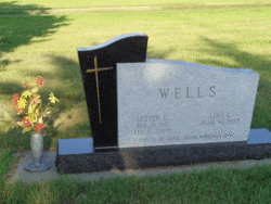
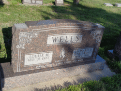
Lester Ellery Wells
| Birth | : | 19 Jan 1921 Cotesfield, Howard County, Nebraska, USA |
| Death | : | 17 Feb 2000 Saint Paul, Howard County, Nebraska, USA |
| Burial | : | Strood Cemetery, Strood, Medway Unitary Authority, England |
| Coordinate | : | 51.3900220, 0.4838640 |
| Description | : | Son of Jacob & Elizabeth (Karre) Wells. Married to Lois Hansen on 6-10-1945 at Scotia, NE. Mr. Wells farmed on the family farm east of Cotesfield his entire life. He also raised cattle and horses. He made his team of Bess and Belle available for many civic and social activities. He enjoyed attending cattle sales |
frequently asked questions (FAQ):
-
Where is Lester Ellery Wells's memorial?
Lester Ellery Wells's memorial is located at: Strood Cemetery, Strood, Medway Unitary Authority, England.
-
When did Lester Ellery Wells death?
Lester Ellery Wells death on 17 Feb 2000 in Saint Paul, Howard County, Nebraska, USA
-
Where are the coordinates of the Lester Ellery Wells's memorial?
Latitude: 51.3900220
Longitude: 0.4838640
Family Members:
Parent

Spouse
Siblings
Children
Flowers:


Nearby Cemetories:
1. Strood Cemetery
Strood, Medway Unitary Authority, England
Coordinate: 51.3900220, 0.4838640
2. St Nicholas with St Mary Churchyard
Strood, Medway Unitary Authority, England
Coordinate: 51.3959790, 0.4931350
3. St Margaret Churchyard
Rochester, Medway Unitary Authority, England
Coordinate: 51.3849380, 0.4993630
4. Rochester Castle Moat Burial Ground
Rochester, Medway Unitary Authority, England
Coordinate: 51.3894140, 0.5024580
5. Rochester Cathedral
Rochester, Medway Unitary Authority, England
Coordinate: 51.3889750, 0.5031160
6. St Nicholas Churchyard
Rochester, Medway Unitary Authority, England
Coordinate: 51.3894170, 0.5035320
7. Rochester Baptist Church
Rochester, Medway Unitary Authority, England
Coordinate: 51.3871570, 0.5052370
8. St. Margaret's Cemetery
Rochester, Medway Unitary Authority, England
Coordinate: 51.3777000, 0.5011600
9. St Matthew Churchyard
Borstal, Medway Unitary Authority, England
Coordinate: 51.3736150, 0.4868020
10. St. Nicholas's Cemetery
Rochester, Medway Unitary Authority, England
Coordinate: 51.3780081, 0.5021076
11. All Saints Churchyard
Frindsbury, Medway Unitary Authority, England
Coordinate: 51.4004440, 0.5058970
12. Fort Pitt Military Cemetery
Rochester, Medway Unitary Authority, England
Coordinate: 51.3769790, 0.5114570
13. Chatham Unitarian Church
Chatham, Medway Unitary Authority, England
Coordinate: 51.3826090, 0.5195850
14. St Mary Churchyard
Chatham, Medway Unitary Authority, England
Coordinate: 51.3874550, 0.5244280
15. St. Michael and All Angels Churchyard
Cuxton, Medway Unitary Authority, England
Coordinate: 51.3714120, 0.4546760
16. Chatham Burial Ground
Chatham, Medway Unitary Authority, England
Coordinate: 51.3849900, 0.5272600
17. Brompton War Memorial
Chatham, Medway Unitary Authority, England
Coordinate: 51.3932140, 0.5293660
18. St John Evangelist Churchyard
Higham, Gravesham Borough, England
Coordinate: 51.4162102, 0.4616890
19. Chatham Naval Memorial
Chatham, Medway Unitary Authority, England
Coordinate: 51.3836479, 0.5321670
20. Chatham Maidstone Road Cemetery
Chatham, Medway Unitary Authority, England
Coordinate: 51.3703300, 0.5227600
21. St George Churchyard
Chatham, Medway Unitary Authority, England
Coordinate: 51.3974070, 0.5346770
22. St Philip and St James Churchyard
Upnor, Medway Unitary Authority, England
Coordinate: 51.4106250, 0.5250480
23. Chatham Palmerston Road Cemetery
Chatham, Medway Unitary Authority, England
Coordinate: 51.3678600, 0.5267300
24. All Saints Churchyard
Wouldham, Tonbridge and Malling Borough, England
Coordinate: 51.3528130, 0.4580580