
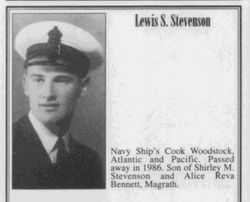
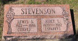
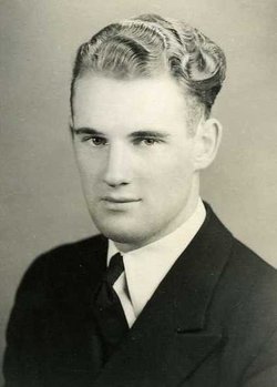
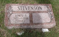

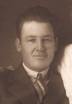
Lewis Shirl Stevenson
| Birth | : | 30 Aug 1922 Cardston, Claresholm Census Division, Alberta, Canada |
| Death | : | 28 Jun 1986 Calgary, Calgary Census Division, Alberta, Canada |
| Burial | : | Israel Church Cemetery, Kerens, Randolph County, USA |
| Coordinate | : | 39.0266609, -79.8208618 |
frequently asked questions (FAQ):
-
Where is Lewis Shirl Stevenson's memorial?
Lewis Shirl Stevenson's memorial is located at: Israel Church Cemetery, Kerens, Randolph County, USA.
-
When did Lewis Shirl Stevenson death?
Lewis Shirl Stevenson death on 28 Jun 1986 in Calgary, Calgary Census Division, Alberta, Canada
-
Where are the coordinates of the Lewis Shirl Stevenson's memorial?
Latitude: 39.0266609
Longitude: -79.8208618
Family Members:
Parent
Spouse

Siblings
Flowers:


Nearby Cemetories:
1. Israel Church Cemetery
Kerens, Randolph County, USA
Coordinate: 39.0266609, -79.8208618
2. Primitive Baptist Church Cemetery
Montrose, Randolph County, USA
Coordinate: 39.0646330, -79.8187350
3. Coffman Chapel Cemetery
Elkins, Randolph County, USA
Coordinate: 38.9874280, -79.8205900
4. Mountain State Memorial Gardens
Elkins, Randolph County, USA
Coordinate: 38.9836006, -79.8360977
5. Peter Warner Cemetery #19
Cherry Grove, Pendleton County, USA
Coordinate: 38.9745600, -79.8467300
6. Gilman Cemetery
Gilman, Randolph County, USA
Coordinate: 38.9682750, -79.8448670
7. Laurel Hill Battlefield Cemetery
Belington, Barbour County, USA
Coordinate: 39.0084890, -79.9084750
8. Stringtown Cemetery
Belington, Barbour County, USA
Coordinate: 39.0338920, -79.9118590
9. Wilmoth-Isner Cemetery
Elkins, Randolph County, USA
Coordinate: 38.9573970, -79.7767230
10. Baxter Wilmoth Cemetery
Elkins, Randolph County, USA
Coordinate: 38.9573850, -79.7766400
11. Mouse Cemetery
Elkins, Randolph County, USA
Coordinate: 38.9488370, -79.8299000
12. Little Arlington Cemetery
Elkins, Randolph County, USA
Coordinate: 38.9482994, -79.8308029
13. Old Right Cemetery
Belington, Barbour County, USA
Coordinate: 39.0214600, -79.9269900
14. Parsons Family Cemetery
Pleasant Run, Tucker County, USA
Coordinate: 39.0320000, -79.7145000
15. Irons Chapel Cemetery
Porterwood, Tucker County, USA
Coordinate: 39.0322830, -79.7138850
16. Sugar Creek Cemetery
Belington, Barbour County, USA
Coordinate: 39.0610840, -79.9218200
17. Elliott Cemetery
Belington, Barbour County, USA
Coordinate: 39.0264780, -79.9320850
18. Lambert Chapel Cemetery
Belington, Barbour County, USA
Coordinate: 39.0765550, -79.9119050
19. Maplewood Cemetery
Elkins, Randolph County, USA
Coordinate: 38.9417000, -79.8510971
20. Hedrick Vandevander Cemetery
Cherry Grove, Pendleton County, USA
Coordinate: 38.9843300, -79.9206700
21. Mount Zion Church Cemetery
Elkins, Randolph County, USA
Coordinate: 38.9438400, -79.7733700
22. Old Catholic Cemetery
Elkins, Randolph County, USA
Coordinate: 38.9335117, -79.8391259
23. Whitman Ward Family Cemetery
Elkins, Randolph County, USA
Coordinate: 38.9444900, -79.8822330
24. Harsh Cemetery
Saint George, Tucker County, USA
Coordinate: 39.1197290, -79.7946770