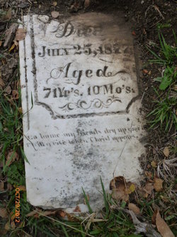
| Birth | : | 16 Dec 1819 Edgar County, Illinois, USA |
| Death | : | 28 Apr 1882 Humboldt, Richardson County, Nebraska, USA |
| Burial | : | Brown Cemetery, Rock Cave, Upshur County, USA |
| Coordinate | : | 38.8065600, -80.3857820 |
| Description | : | Liberty Wilson was born a son to, Thomas Wilson, and his wife, Nancy [KEEL] Wilson. He was born in Edgar County, Illinois, 16 December 1819. In Edgar County, Illinois, 30 November 1839, he married, Catherine Ripple Stump. She was a daughter to, David Washbaugh Stump, and his wife, Catherine [RIPPLE] Stump. Together, Liberty Wilson, and his wife, Catherine Ripple [STUMP] Wilson, shared five known children. Liberty Wilson died in Humboldt, Richardson, NE., 28 April 1882. |
frequently asked questions (FAQ):
-
Where is Liberty Wilson's memorial?
Liberty Wilson's memorial is located at: Brown Cemetery, Rock Cave, Upshur County, USA.
-
When did Liberty Wilson death?
Liberty Wilson death on 28 Apr 1882 in Humboldt, Richardson County, Nebraska, USA
-
Where are the coordinates of the Liberty Wilson's memorial?
Latitude: 38.8065600
Longitude: -80.3857820
Family Members:
Parent
Spouse
Siblings
Children
Flowers:
Nearby Cemetories:
1. Cow Run School Cemetery
Rock Cave, Upshur County, USA
Coordinate: 38.8094090, -80.3816080
2. Heaston Cemetery
Kanawha Head, Upshur County, USA
Coordinate: 38.7969100, -80.3776400
3. Cow Run Cemetery
Rock Cave, Upshur County, USA
Coordinate: 38.8065910, -80.3588530
4. Hevener Family Cemetery
Roanoke, Lewis County, USA
Coordinate: 38.8077460, -80.4250480
5. Chestnut Flat Cemetery
Rock Cave, Upshur County, USA
Coordinate: 38.8391991, -80.3811035
6. Kincaid Cemetery
Duffy, Lewis County, USA
Coordinate: 38.7858390, -80.4185540
7. Wimer Cemetery
Rock Cave, Upshur County, USA
Coordinate: 38.8407593, -80.3906555
8. Arlington Cemetery
Arlington, Upshur County, USA
Coordinate: 38.8020400, -80.3416910
9. Bennett Cemetery
Upshur County, USA
Coordinate: 38.7749063, -80.3555116
10. McCutcheon Chapel Cemetery
Ireland, Lewis County, USA
Coordinate: 38.8115200, -80.4373460
11. Rock Cave Cemetery
Rock Cave, Upshur County, USA
Coordinate: 38.8367004, -80.3494034
12. Lee Cemetery
Kanawha Head, Upshur County, USA
Coordinate: 38.7787000, -80.3431390
13. Oak Grove Cemetery
Upshur County, USA
Coordinate: 38.7697200, -80.3500000
14. Saul Smith Farm Cemetery
Crawford, Lewis County, USA
Coordinate: 38.8491950, -80.4149770
15. Taylor Chapel Cemetery
Crawford, Lewis County, USA
Coordinate: 38.8497370, -80.4145380
16. Pickens Cemetery
Duffy, Lewis County, USA
Coordinate: 38.7921982, -80.4475021
17. Fair Haven Church Cemetery
Ireland, Lewis County, USA
Coordinate: 38.8333610, -80.4402740
18. McCray Cemetery
Ireland, Lewis County, USA
Coordinate: 38.7963700, -80.4533280
19. Reger Farm Cemetery
Ireland, Lewis County, USA
Coordinate: 38.8150030, -80.4563910
20. Hull-Leatherbark Run Cemetery
Walkersville, Lewis County, USA
Coordinate: 38.8469700, -80.4380100
21. Hedding Chapel Cemetery
Walkersville, Lewis County, USA
Coordinate: 38.8425590, -80.4499710
22. Salem Ridge Cemetery
Gaines, Upshur County, USA
Coordinate: 38.7821200, -80.3130500
23. Kanawha Run Church Cemetery
French Creek, Upshur County, USA
Coordinate: 38.8347751, -80.3109749
24. Kanawha Run Cemetery
Arlington, Upshur County, USA
Coordinate: 38.8348770, -80.3108990


