
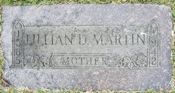
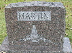
Lillian Doll Martin
| Birth | : | 28 Dec 1885 Shelbyville, Shelby County, Missouri, USA |
| Death | : | 18 Feb 1942 Miller County, Missouri, USA |
| Burial | : | Mount Hope Cemetery, Independence, Buchanan County, USA |
| Coordinate | : | 42.4571991, -91.8914032 |
| Description | : | THE ELDON ADVERTISER, Eldon, Missouri, Thursday, Feb. 26, 1942 FUNERAL SUNDAY FOR MRS. ROSS G. MARTIN OF OLEAN Lillian Elizabeth Doll died at St. Mary's Hospital in Jefferson City, Feb. 18, at the age of 56 years, 1 month and 20 days. She was born Dec. 28, 1885, the daughter of John and Clementine Doll, who have both passed on. On May 17, 1918, she was married to Ross G. Martin in Hugoton, Kansas. To them three children were born, Helen and Tina Bess, who are in the home, and Ross George, Jr. of the Marine Corps in Paris Island, South... Read More |
frequently asked questions (FAQ):
-
Where is Lillian Doll Martin's memorial?
Lillian Doll Martin's memorial is located at: Mount Hope Cemetery, Independence, Buchanan County, USA.
-
When did Lillian Doll Martin death?
Lillian Doll Martin death on 18 Feb 1942 in Miller County, Missouri, USA
-
Where are the coordinates of the Lillian Doll Martin's memorial?
Latitude: 42.4571991
Longitude: -91.8914032
Family Members:
Parent

Siblings


Nearby Cemetories:
1. Mount Hope Cemetery
Independence, Buchanan County, USA
Coordinate: 42.4571991, -91.8914032
2. West Haven Cemetery
Independence, Buchanan County, USA
Coordinate: 42.4588678, -91.8986696
3. Oakwood Cemetery
Independence, Buchanan County, USA
Coordinate: 42.4627991, -91.8927994
4. Saint Johns Catholic Cemetery
Independence, Buchanan County, USA
Coordinate: 42.4822006, -91.8957977
5. State Hospital Cemetery
Independence, Buchanan County, USA
Coordinate: 42.4455986, -91.9253006
6. Wilson Cemetery
Independence, Buchanan County, USA
Coordinate: 42.4658012, -91.8516998
7. Buchanan County Poor Farm Cemetery
Independence, Buchanan County, USA
Coordinate: 42.4871560, -91.8647280
8. Buchanan County Home Cemetery
Independence, Buchanan County, USA
Coordinate: 42.4903050, -91.8596350
9. Otterville Cemetery
Buchanan County, USA
Coordinate: 42.5158005, -91.9392014
10. Pine Creek Cemetery
Quasqueton, Buchanan County, USA
Coordinate: 42.4172400, -91.7867200
11. Rowley Cemetery
Rowley, Buchanan County, USA
Coordinate: 42.3716621, -91.8530655
12. Hickory Grove Cemetery
Quasqueton, Buchanan County, USA
Coordinate: 42.4207598, -91.7534684
13. Quasqueton Cemetery
Quasqueton, Buchanan County, USA
Coordinate: 42.3994370, -91.7621231
14. Fairview Cemetery
Winthrop, Buchanan County, USA
Coordinate: 42.4692001, -91.7407990
15. Cedar Crest Cemetery
Jesup, Buchanan County, USA
Coordinate: 42.4782982, -92.0406036
16. Saint Athanasius Cemetery
Jesup, Buchanan County, USA
Coordinate: 42.4761009, -92.0421982
17. Saint Patricks Cemetery
Winthrop, Buchanan County, USA
Coordinate: 42.4653015, -91.7328033
18. Littleton Cemetery
Littleton, Buchanan County, USA
Coordinate: 42.5338593, -92.0179520
19. Payne Cemetery
Winthrop, Buchanan County, USA
Coordinate: 42.5203018, -91.7453003
20. Fremont Township Cemetery
Winthrop, Buchanan County, USA
Coordinate: 42.5046997, -91.7264023
21. Byron Township Cemetery
Buchanan County, USA
Coordinate: 42.5271988, -91.7275009
22. Shady Grove Cemetery
Jesup, Buchanan County, USA
Coordinate: 42.3805453, -92.0557342
23. Amish Cemetery
Buchanan County, USA
Coordinate: 42.5689011, -92.0224991
24. Fontana Cemetery
Hazleton, Buchanan County, USA
Coordinate: 42.6046982, -91.9052963