
| Birth | : | 16 Oct 1912 High River, Calgary Census Division, Alberta, Canada |
| Death | : | 19 Oct 1996 Vulcan, Strathmore Census Division, Alberta, Canada |
| Burial | : | Vulcan Cemetery, Vulcan, Strathmore Census Division, Canada |
| Coordinate | : | 50.4032200, -113.2774100 |
| Plot | : | Block 5 Lot 414 Grave NE |
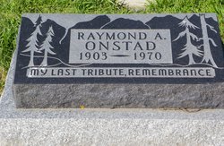
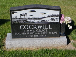
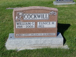
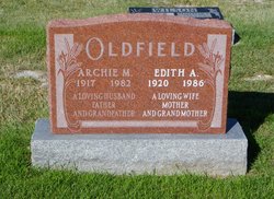
| Description | : | VULCAN FUNERAL HOME - OBIT EXCERPTS LILLIAN FLORENCE ONSTAD PASSED AWAY PEACEFULLY OCTOBER 19, 1996 AT VULCAN, ALBERTA AT THE AGE OF 84 YEARS. LILLIAN WAS BORN OCTOBER 16, 1912 AT HIGH RIVER, ALBERTA, THE FIRST CHILD OF SYDNEY AND ELLEN COCKWILL, BOTH OF WHOM CAME FROM ENGLAND. LILLIAN AND RAY ONSTAD WERE MARRIED IN THE LATE 1920’s AT THE ANGLICAN CHURCH IN HIGH RIVER, THE SAME CHURCH WHERE HER PARENTS HAD BEEN MARRIED. LILLIAN WAS PREDECEASED BY HER HUSBAND , A BROTHER BUCK AND HIS WIFE HELEN, A SISTER BERTIE AND HER HUSBAND ARCHIE OLDFIELD AND HER PARENTS. |
frequently asked questions (FAQ):
-
Where is Lillian Florence Cockwill Onstad's memorial?
Lillian Florence Cockwill Onstad's memorial is located at: Vulcan Cemetery, Vulcan, Strathmore Census Division, Canada.
-
When did Lillian Florence Cockwill Onstad death?
Lillian Florence Cockwill Onstad death on 19 Oct 1996 in Vulcan, Strathmore Census Division, Alberta, Canada
-
Where are the coordinates of the Lillian Florence Cockwill Onstad's memorial?
Latitude: 50.4032200
Longitude: -113.2774100
Family Members:
Parent
Spouse
Siblings
Flowers:


Nearby Cemetories:
1. Vulcan Cemetery
Vulcan, Strathmore Census Division, Canada
Coordinate: 50.4032200, -113.2774100
2. Highland Cemetery
Vulcan, Strathmore Census Division, Canada
Coordinate: 50.4845700, -113.2659100
3. Cleverville Cemetery
Champion, Strathmore Census Division, Canada
Coordinate: 50.2736100, -113.1661700
4. Reid Hill Cemetery
Vulcan, Strathmore Census Division, Canada
Coordinate: 50.3974000, -113.0295500
5. Brant Cemetery
Brant, Strathmore Census Division, Canada
Coordinate: 50.5067400, -113.5068000
6. Fath Hill Catholic Cemetery
Champion, Strathmore Census Division, Canada
Coordinate: 50.2153400, -113.2544200
7. Champion Cemetery
Champion, Strathmore Census Division, Canada
Coordinate: 50.2329200, -113.1441800
8. Sharon Cemetery
Brant, Strathmore Census Division, Canada
Coordinate: 50.4555300, -113.5740800
9. Little Bow Hutterite Cemetery
Stavely, Claresholm Census Division, Canada
Coordinate: 50.2142141, -113.3694417
10. Isol Russell Grave
Champion, Strathmore Census Division, Canada
Coordinate: 50.1792300, -113.2102100
11. Alston Cemetery
Vulcan, Strathmore Census Division, Canada
Coordinate: 50.1652820, -113.2450470
12. Arrowwood Hutterite Cemetery
Herronton, Strathmore Census Division, Canada
Coordinate: 50.6368299, -113.4157544
13. High River Hutterite Cemetery
High River, Calgary Census Division, Canada
Coordinate: 50.4816260, -113.6618863
14. Frankburg Cemetery
High River, Calgary Census Division, Canada
Coordinate: 50.5287300, -113.6445850
15. Krasivaya Dolina Cemetery
Queenstown, Strathmore Census Division, Canada
Coordinate: 50.5908100, -112.9593600
16. Carmangay Cemetery
Carmangay, Strathmore Census Division, Canada
Coordinate: 50.1214300, -113.1434300
17. Hope Lutheran Cemetery
Milo, Strathmore Census Division, Canada
Coordinate: 50.6013300, -112.9238900
18. Blackie Cemetery
Blackie, Calgary Census Division, Canada
Coordinate: 50.6084400, -113.6290500
19. St. Cecilia's Roman Catholic Cemetery
Nanton, Claresholm Census Division, Canada
Coordinate: 50.3588000, -113.7591600
20. Nanton Town Cemetery
Nanton, Claresholm Census Division, Canada
Coordinate: 50.3333800, -113.7586100
21. Saint Vincent Roman Catholic Cemetery
Stavely, Claresholm Census Division, Canada
Coordinate: 50.1717670, -113.6409830
22. Shadow Ranch Hutterite Cemetery
Champion, Strathmore Census Division, Canada
Coordinate: 50.1820466, -112.8929664
23. Arrowwood Cemetery
Arrowwood, Strathmore Census Division, Canada
Coordinate: 50.7211418, -113.1209030
24. Stavely Cemetery
Stavely, Claresholm Census Division, Canada
Coordinate: 50.1646700, -113.6625600