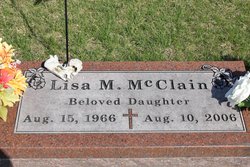
Lisa Marie McClain
| Birth | : | 15 Aug 1967 |
| Death | : | 10 Aug 2006 |
| Burial | : | St. Andrew's Churchyard, Prestwold, Charnwood Borough, England |
| Coordinate | : | 52.7875000, -1.1446400 |
| Description | : | Lisa ,39, of Oelwein,IA was survived by her parents, Don and Mary Lou of Oelwein and two brothers, Steven of Oelwein and David of North Liberty,IA. Services were held at the First Baptist Church,Oelwein by Rev Tim Schoepf and Rev Mike Campbell. |
frequently asked questions (FAQ):
-
Where is Lisa Marie McClain's memorial?
Lisa Marie McClain's memorial is located at: St. Andrew's Churchyard, Prestwold, Charnwood Borough, England.
-
When did Lisa Marie McClain death?
Lisa Marie McClain death on 10 Aug 2006 in
-
Where are the coordinates of the Lisa Marie McClain's memorial?
Latitude: 52.7875000
Longitude: -1.1446400
Family Members:
Parent
Siblings
Flowers:
Nearby Cemetories:
1. St. Andrew's Churchyard
Prestwold, Charnwood Borough, England
Coordinate: 52.7875000, -1.1446400
2. Prestwold Natural Burial Ground
Loughborough, Charnwood Borough, England
Coordinate: 52.7779510, -1.1538520
3. Hoton Burial Ground
Hoton, Charnwood Borough, England
Coordinate: 52.7983472, -1.1500767
4. Burton-on-the-Wolds Burial Ground
Burton-on-the-Wolds, Charnwood Borough, England
Coordinate: 52.7864470, -1.1207120
5. St Mary Churchyard
Walton-on-the-Wolds, Charnwood Borough, England
Coordinate: 52.7712900, -1.1241310
6. Wymeswold Rempstone Road Cemetery
Wymeswold, Charnwood Borough, England
Coordinate: 52.8084600, -1.1180480
7. Barrow-Upon-Soar Cemetery
Barrow-upon-Soar, Charnwood Borough, England
Coordinate: 52.7620220, -1.1585640
8. All Saints Churchyard
Rempstone, Rushcliffe Borough, England
Coordinate: 52.8149800, -1.1477700
9. St. Marys Churchyard
Wymeswold, Charnwood Borough, England
Coordinate: 52.8055010, -1.1067320
10. Rempstone Anabaptist Burial Ground
Rempstone, Rushcliffe Borough, England
Coordinate: 52.8179800, -1.1426400
11. Rempstone, St Peter in the Rushes
Rempstone, Rushcliffe Borough, England
Coordinate: 52.8191600, -1.1614400
12. Holy Trinity Churchyard
Barrow-upon-Soar, Charnwood Borough, England
Coordinate: 52.7526930, -1.1470900
13. All Saints with Holy Trinity Churchyard
Loughborough, Charnwood Borough, England
Coordinate: 52.7743880, -1.2035500
14. Loughborough Cemetery
Loughborough, Charnwood Borough, England
Coordinate: 52.7599400, -1.1951700
15. Loughborough Crematorium
Loughborough, Charnwood Borough, England
Coordinate: 52.7575650, -1.1965200
16. Emmanuel Churchyard
Loughborough, Charnwood Borough, England
Coordinate: 52.7668830, -1.2108020
17. St Giles Churchyard
Costock, Rushcliffe Borough, England
Coordinate: 52.8326300, -1.1489100
18. St Bartholomews Parish Churchyard
Quorn, Charnwood Borough, England
Coordinate: 52.7440274, -1.1703330
19. Seagrave Swan Street Cemetery
Seagrave, Charnwood Borough, England
Coordinate: 52.7520370, -1.0883200
20. Mountsorrel Cemetery
Mountsorrel, Charnwood Borough, England
Coordinate: 52.7378380, -1.1547880
21. Quorn Baptist Churchyard
Quorn, Charnwood Borough, England
Coordinate: 52.7407600, -1.1753200
22. All Saints Churchyard
Seagrave, Charnwood Borough, England
Coordinate: 52.7525110, -1.0829090
23. Holy Trinity Churchyard
Wysall, Rushcliffe Borough, England
Coordinate: 52.8383300, -1.1044200
24. All Saints Churchyard
Thorpe Acre, Charnwood Borough, England
Coordinate: 52.7750466, -1.2361551


